New Jersey Route 152
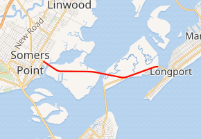
Route 152 is a 3.16-mile-long (5.09 km) state highway in Atlantic County, New Jersey, United States. Route 152 begins at an intersection with County Route 620 and County Route 635 in the city of Somers Point. The route heads along two causeways, ending at the foot of the John F. Kennedy Memorial Bridge over the Intracoastal Waterway in Egg Harbor Township, where the state turns maintenance back to Atlantic County as County Route 629 to Longport.
| ||||
|---|---|---|---|---|
| Longport-Somers Point Boulevard | ||||
| ||||
| Route information | ||||
| Maintained by NJDOT | ||||
| Length | 3.16 mi[1] (5.09 km) | |||
| Existed | 1969–present | |||
| Major junctions | ||||
| West end | ||||
| East end | ||||
| Location | ||||
| Counties | Atlantic | |||
| Highway system | ||||
New Jersey State Highway Routes
| ||||

Route 152 originates as an alignment of Atlantic County Route 20, which ran along the entire alignment of Route 152 from Somers Point to Longport. The state took over Route 20 in 1969, designating the route as 152 in relation to the Route 52 designation further south. In 1988, the former bridge over the Broad Thoroughfare was demolished and replaced by the Dolores G. Cooper Bridge.
Route description
_just_west_of_Ocean_City-Longport_Boulevard_in_Egg_Harbor_Township%2C_Atlantic_County%2C_New_Jersey.jpg)
Route 152 begins at an intersection with Atlantic County Route 620 (West Maryland Avenue) and 635 (Bay Avenue) in the city of Somers Point. The route heads eastward, passing to the north of a local marina as East Maryland Avenue, crossing over Bass Harbor Creek soon after. Just after crossing the creek, Route 152 leaves Somers Point, entering the community of Egg Harbor Township. On the other side of the creek, Route 152 becomes known as Longport–Somers Point Boulevard and heads along a causeway through Egg Harbor Township. The route passes to the north of a marina, curving soon after at an intersection with Anchorage Drive, which is a connector road to waterside residential homes.[2]
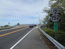
Route 152 continues eastward, crossing over several streams and passing to the north of a large estate. The route remains a two-lane causeway for a distance, intersecting with its former alignment to the south, which parallels the current route. Route 152 then rises in elevation as it heads onto the newer causeway (known as the Dolores G. Cooper Bridge), passing a lone fishing pier. After crossing over the Cooper Bridge, the highway parallels its former alignment for a short distance, intersecting with the Ocean Drive/Ocean City-Longport Boulevard. Route 152 heads along the Broad Thoroughfare as a three-lane waterside arterial boulevard. The route leaves the shoreline, running along the sandy surroundings. The route reaches Seaview Harbor, served by an intersection with Sunset Boulevard and Seaview Boulevard. Route 152 turns eastward, reaching the foot of the John F. Kennedy Memorial Bridge. There, the state designation ends, and it continues as Atlantic County Route 629 (Ventnor Avenue) into Longport.[2]
The entire span of the Longport Bridge is accessible to pedestrians, runners, and bicycles, with dedicated lanes on each side. The bridge has been a featured route in running, walking, and cycling events including the Bike MS: City to Shore Ride.
History
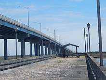
In 1916, the causeway connecting Somers Point and Longport opened.[3] The current alignment of Route 152 originates as a state takeover of Atlantic County Route 20, which was first brought to the floor of the New Jersey State Legislature in 1968. The state approved the measure, and effective January 19, 1969, the New Jersey Department of Transportation took over maintenance of County Route 20.[4] The alignment was designated as Route 152, numbered after nearby New Jersey Route 52 to the south in Somers Point and Ocean City. Route 152 originally went along a lower bridge across the Broad Thoroughfare. In 1988, a new 2,860-foot-long (870 m) bridge, named the Dolores G. Cooper Bridge, was completed to the north of the former route.[5] The former alignment to the south, designated as Old Road,[1] is currently being demolished with the former fishing pier as of 2017. The route has remained intact virtually since 1988.[6]
The original alignment of Route 152 was designated by 1953 from Route 29 (which at the time went east via Memorial Drive and Lafayette Street to US 206) in Trenton to US 1 in Trenton. This became part of rerouted Route 29 by 1969, while the old route of Route 29 was given to the city.
Major intersections
The entire route is in Atlantic County.
| Location | mi[1] | km | Destinations | Notes | |
|---|---|---|---|---|---|
| Somers Point | 0.00 | 0.00 | |||
| Egg Harbor Township | 2.26 | 3.64 | West end of Ocean Drive overlap | ||
| 3.16 | 5.09 | East end of Ocean Drive overlap | |||
| 1.000 mi = 1.609 km; 1.000 km = 0.621 mi | |||||
See also


References
- "Route 152 straight line diagram" (PDF). New Jersey Department of Transportation. Retrieved March 17, 2020.
- Overview map of Route 152 (Map). Cartography by NAVTEQ Inc. Bing Maps. 2009. Retrieved October 19, 2009.
- New Jersey Historic Bridge Survey (PDF). A. G. Lichtenstein & Associates (Report). New Jersey Department of Transportation. September 1994. p. 90. Retrieved July 16, 2018.
- "397". ROUTE NO. ----. Beginning at or in the vicinity of the westerly abutment line of the John F. Kennedy Memorial Bridge over Risley Channel in Atlantic county and thence proceeding toward Somers Point in said county and being presently designated as Atlantic County Route No. 20. New Jersey State Legislature. 1968.
- Inventory, National Bridge (2008). Structure Number: ++++++++0122155. United States Department of Transportation. p. 1.
- New Jersey Official Road Map (Map). Cartography by New Jersey Department of Transportation. New Jersey Department of Transportation. 2007.
External links
| Wikimedia Commons has media related to New Jersey Route 152. |