List of listed buildings in Innerleithen, Scottish Borders
List
| Name | Location | Date Listed | Grid Ref. [note 1] | Geo-coordinates | Notes | LB Number [note 2] | Image |
|---|---|---|---|---|---|---|---|
| Leithen Road, Old Bridge | 55°37′24″N 3°03′37″W | Category C(S) | 34969 |  | |||
| 15 Pirn Road | 55°37′14″N 3°03′35″W | Category C(S) | 34971 | | |||
| Holylee, Lodge | 55°37′37″N 2°58′10″W | Category C(S) | 49124 | | |||
| Leithen Water, Weir, Sluice, Bridge And Mill Lade | 55°38′08″N 3°03′20″W | Category C(S) | 49128 | | |||
| Walkerburn, Caberston Farm House And Steading | 55°37′29″N 3°01′12″W | Category C(S) | 49130 | | |||
| Walkerburn, Galashiels Road, Stoneyhill Cottage (Former Stoneyhill Lodge) Including Boundary Wall And Gatepier | 55°37′25″N 3°00′52″W | Category A | 49134 | | |||
| 24 And 26 Chapel Street, Lothian And Borders Co-Operative Society Ltd | 55°37′13″N 3°03′44″W | Category C(S) | 51074 | | |||
| Leithen Road, Kirklands Farmhouse Including Boundary Walls And Gatepiers | 55°37′33″N 3°03′34″W | Category C(S) | 51082 | | |||
| St Ronan's Terrace, Tiendside Including Boundary Walls | 55°37′16″N 3°04′07″W | Category C(S) | 51089 | | |||
| Damside, Ballantyne Cashmere Uk, Caerlee Mill Including Boilerhouse, Chimney, Weaving Sheds, Ancillary Buildings, Boundary Walls And Gatepiers | 55°37′16″N 3°03′50″W | Category B | 34968 | | |||
| Walkerburn, Galashiels Road, Stoneyhill House, Stables And Boundary Walls | 55°37′30″N 3°00′47″W | Category A | 12930 | | |||
| Nether Horsburgh Farm House, Walled Garden And Farm Buildings | 55°38′41″N 3°06′24″W | Category B | 8333 | | |||
| Glenormiston, Garden Cottage, Garden Wall And Ha - Ha | 55°37′49″N 3°05′18″W | Category C(S) | 49119 | | |||
| Holylee Farm, Holylee Cottages | 55°37′43″N 2°58′03″W | Category C(S) | 49123 | | |||
| Holylee, Walled Garden | 55°37′41″N 2°58′08″W | Category C(S) | 49125 | | |||
| Kirnie Law Reservoir And Surge Tower | 55°38′15″N 3°02′12″W | Category B | 49126 | | |||
| Walkerburn, Galashiels Road, Walkerburn Parish Church (Church Of Scotland) Including Boundary Walls | 55°37′28″N 3°00′42″W | Category B | 49133 | | |||
| 1 Buccleuch Street, Innerleithen Public Library Including Boundary Walls | 55°37′11″N 3°03′35″W | Category C(S) | 51073 | | |||
| Church Street, St Andrews Episcopal Church Including Boundary Walls And Gates | 55°37′20″N 3°03′43″W | Category C(S) | 51075 | | |||
| 5, 7, 9 And 11 High Street, Robert Smail's Printing Works, Including Printing Works, Courtyard And Mill Lade | 55°37′10″N 3°03′43″W | Category C(S) | 51077 | | |||
| Peebles Road, Easter And Wester Caerlee (Formerly Caerlee House) Including Wash House And Garage | 55°37′00″N 3°04′21″W | Category C(S) | 51086 | | |||
| Waverley Road, Runic Cross Including Boundary Walls | 55°37′06″N 3°03′47″W | Category C(S) | 51090 | | |||
| Walkerburn, Galashiels Road, Sunnybrae Lodge Including Gatepiers, Stables And Boundary Walls | 55°37′25″N 3°00′54″W | Category A | 49136 | | |||
| 91 High Street And St James Hall (Formerly St James Rc School And Schoolhouse) Including Boundary Walls | 55°37′06″N 3°03′53″W | Category C(S) | 51076 | | |||
| 2 Leithen Crescent, Vale Of Leithen Social Club Including Boundary Walls And Railings | 55°37′11″N 3°03′41″W | Category C(S) | 51081 | | |||
| Leithen Road, Municipal Buildings And Memorial Hall | 55°37′15″N 3°03′43″W | Category C(S) | 51084 | | |||
| Peebles Road, Alpinebikes, Former Congregational Chapel | 55°37′05″N 3°04′01″W | Category C(S) | 51085 | | |||
| St Ronan's Terrace, Glenroy (Formerly St Ronan's Lodge) Including Boundary Walls | 55°37′24″N 3°04′04″W | Category C(S) | 51087 | | |||
| St Ronan's Terrace, The Pines (Formerly Bellenden) Including Garden Walls, Steps, Ancillary Structures, Boundary Walls Gates And Gatepiers | 55°37′15″N 3°04′07″W | Category B | 51088 | | |||
| Morningside Meikle Sawmill Wheelhouse And Turbine House Including Mill Lade | 55°37′05″N 3°03′41″W | Category C(S) | 34976 | | |||
| Glenormiston, Lodge Including Gatepiers, Gates And Railings | 55°37′42″N 3°05′40″W | Category C(S) | 8319 | | |||
| Walkerburn, The Kirna | 55°37′34″N 3°01′57″W | Category A | 8323 | 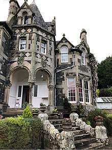 | |||
| Glenormiston, Velvet Hall Cottage | 55°37′32″N 3°05′20″W | Category C(S) | 49121 | | |||
| Walkerburn, Bascule Bridge (Over The River Tweed) | 55°37′19″N 3°01′01″W | Category C(S) | 49129 | | |||
| Walkerburn, Galashiels Road, Sunnybrae House | 55°37′27″N 3°00′58″W | Category C(S) | 49135 | | |||
| Walkerburn, Galashiels Road, Tweedvale House | 55°37′27″N 3°01′01″W | Category C(S) | 49138 | | |||
| High Street, St James Roman Catholic Church And Presbytery Including Boundary Walls And Gatepiers | 55°37′05″N 3°03′54″W | Category B | 34974 | | |||
| Walkerburn, Prefabricated Cast - Iron Urinal | 55°37′26″N 3°01′11″W | Category A | 8326 |  | |||
| Walkerburn, Caberston Road, Ballantyne Memorial Institute | 55°37′21″N 3°01′03″W | Category C(S) | 49131 | | |||
| 13A And 15 High Street | 55°37′10″N 3°03′44″W | Category C(S) | 51078 | | |||
| 2 High Street, Bank Of Scotland | 55°37′11″N 3°03′44″W | Category C(S) | 51079 | | |||
| Leithen Road, Leithen Bank | 55°37′31″N 3°03′35″W | Category C(S) | 51083 | | |||
| Leithen Road, Innerleithen Parish Church Including Runic Cross, Boundary Walls, Gates And Gatepiers | 55°37′17″N 3°03′45″W | Category B | 34966 | | |||
| Walkerburn, Galashiels Road, Lodge to Tweedvale House | 55°37′25″N 3°00′59″W | Category B | 12931 | | |||
| Glenormiston House | 55°37′51″N 3°05′20″W | Category C(S) | 8318 | | |||
| Lee Tower | 55°38′46″N 3°04′07″W | Category C(S) | 8320 | | |||
| Holylee Including Terrace Wall | 55°37′42″N 2°58′17″W | Category B | 8324 | | |||
| Holylee Farm, Old Holylee | 55°37′46″N 2°58′05″W | Category B | 8325 | | |||
| Leithen Water, Bridge (Near Golf Course) | 55°38′15″N 3°03′25″W | Category C(S) | 49127 | | |||
| Wells Brae, St Ronan's Well, Former Pump Room, Bottling Plant, Ancillary Buildings And Boundary Walls | 55°37′26″N 3°04′03″W | Category B | 34970 | | |||
| Leithen Lodge With Lochend Arch, Outbuildings And Sundial | 55°40′26″N 3°04′53″W | Category A | 13475 | 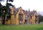 | |||
| Glenormiston, Ivy Bridge | 55°37′44″N 3°05′27″W | Category C(S) | 49120 | | |||
| Glenormiston, Water Tank | 55°37′52″N 3°05′17″W | Category C(S) | 49122 | | |||
| Walkerburn, Galashiels Road, Windlestraw, formerly Tweed Valley Country House, formerly Nether Caberston. Including Steps, Garden Terrace, Greenhouse And Garden Walls | 55°37′33″N 3°00′32″W | Category B | 49137 | | |||
| 42-48 (Even Nos) High Street, St Ronan's View | 55°37′09″N 3°03′49″W | Category C(S) | 51080 | | |||
| Leithen Road, Mansley Lodge And The Green Gates Including Boundary Walls | 55°37′38″N 3°03′32″W | Category C(S) | 34972 | | |||
| Leithen Road, Leithen House Including Boundary Walls | 55°37′24″N 3°03′38″W | Category C(S) | 34973 | | |||
| Walkerburn, Galashiels Road, War Memorial | 55°37′25″N 3°00′56″W | Category C(S) | 8322 | | |||
| Horsburgh, Viaduct | 55°38′24″N 3°06′56″W | Category B | 8327 | | |||
| Walkerburn, Galashiels Road, Holly House (Former Walkerburn Parish Church Manse) | 55°37′29″N 3°00′40″W | Category C(S) | 49132 | |
Key
The scheme for classifying buildings in Scotland is:
- Category A: "buildings of national or international importance, either architectural or historic; or fine, little-altered examples of some particular period, style or building type."[1]
- Category B: "buildings of regional or more than local importance; or major examples of some particular period, style or building type, which may have been altered."[1]
- Category C: "buildings of local importance; lesser examples of any period, style, or building type, as originally constructed or moderately altered; and simple traditional buildings which group well with other listed buildings."[1]
In March 2016 there were 47,288 listed buildings in Scotland. Of these, 8 per cent were Category A, and 50 per cent were Category B, with the rest listed at Category C.[2]
Notes
- Sometimes known as OSGB36, the grid reference (where provided) is based on the British national grid reference system used by the Ordnance Survey.
• "Guide to National Grid". Ordnance Survey. Retrieved 12 December 2007.
• "Get-a-map". Ordnance Survey. Retrieved 17 December 2007. - Historic Environment Scotland assign a unique alphanumeric identifier to each designated site in Scotland, for listed buildings this always begins with "LB", for example "LB12345".
References
- All entries, addresses and coordinates are based on data from Historic Scotland. This data falls under the Open Government Licence
- "What is Listing?". Historic Environment Scotland. Retrieved 29 May 2018.
- Scotland's Historic Environment Audit 2016 (PDF). Historic Environment Scotland and the Built Environment Forum Scotland. pp. 15–16. Retrieved 29 May 2018.
This article is issued from Wikipedia. The text is licensed under Creative Commons - Attribution - Sharealike. Additional terms may apply for the media files.