List of listed buildings in Hawick, Scottish Borders
List
| Name | Location | Date Listed | Grid Ref. [note 1] | Geo-coordinates | Notes | LB Number [note 2] | Image |
|---|---|---|---|---|---|---|---|
| 1, 3 And 5 Howegate | 55°25′16″N 2°47′21″W | Category C(S) | 34647 |  | |||
| Drumlanrig Square, Brown Memorial Fountain And Clock | 55°25′12″N 2°47′25″W | Category B | 34648 | | |||
| 2, 4 And 6 Old Manse Lane, Slitrig Hall | 55°25′14″N 2°47′16″W | Category C(S) | 34655 | | |||
| Slitrig Crescent, The Old Rectory And Riversdale, Including Gatepiers And Boundary Walls | 55°25′07″N 2°47′23″W | Category C(S) | 34665 | | |||
| St Mary's Place, St Mary's And Old Parish Church (Church Of Scotland), With Churchyard, Boundary Walls And Gates | 55°25′14″N 2°47′19″W | Category B | 34612 | | |||
| Tower Knowe, Drumlanrig's Tower, Including Boundary Walls And Railings To S | 55°25′17″N 2°47′17″W | Category B | 34624 | | |||
| 4 And 6 High Street | 55°25′18″N 2°47′16″W | Category C(S) | 34627 | | |||
| 20 And 22 High Street, Crown Business Centre | 55°25′19″N 2°47′13″W | Category C(S) | 34630 | | |||
| 11 High Street, Lloyds Tsb | 55°25′19″N 2°47′17″W | Category B | 34639 | 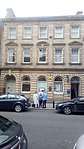 | |||
| 17 High Street | 55°25′19″N 2°47′17″W | Category C(S) | 34640 | | |||
| 23 High Street | 55°25′20″N 2°47′15″W | Category C(S) | 34641 | | |||
| Fenwick | 55°23′56″N 2°50′04″W | Category B | 8380 | | |||
| Crowbyres Bridge | 55°24′45″N 2°47′00″W | Category C(S) | 8398 | | |||
| 6 Howegate | 55°25′16″N 2°47′22″W | Category C(S) | 46411 | | |||
| 45 And 47 North Bridge Street | 55°25′38″N 2°47′04″W | Category B | 48108 | | |||
| 16-20 (Even Numbers) Commercial Road, Turnbull And Scott (Engineers) Ltd, Administration Block And Sheds | 55°25′28″N 2°47′20″W | Category C(S) | 50816 | | |||
| 7-11 (Odd Numbers) Buccleuch Street, Peter Scott's Factory | 55°25′16″N 2°47′26″W | Category C(S) | 51195 | | |||
| 22 Buccleuch Street | 55°25′17″N 2°47′30″W | Category C(S) | 51196 | | |||
| Elm Grove And Orchard Terrace, 1-7 (Inclusive Numbers) Elm Court | 55°25′17″N 2°46′51″W | Category C(S) | 51199 | | |||
| 32 High Street, 2 And 4/1 And 4/2 Cross Wynd, Including The Queens Head Pub | 55°25′21″N 2°47′13″W | Category B | 51214 |  | |||
| 17 North Bridge Street, Elm House Hotel | 55°25′32″N 2°47′03″W | Category C(S) | 51220 | | |||
| 3 Oliver Place | 55°25′28″N 2°47′07″W | Category B | 51222 | | |||
| 4 Oliver Place | 55°25′28″N 2°47′06″W | Category C(S) | 51223 | | |||
| Rosalee Brae, Little Salt Hall | 55°25′35″N 2°47′30″W | Category C(S) | 51228 | | |||
| 17, 18 And 19 Slitrig Crescent | 55°25′07″N 2°47′19″W | Category C(S) | 51230 | | |||
| Sunnyhill Road, Woodnorton | 55°25′29″N 2°48′11″W | Category B | 51234 | | |||
| Wilton Park, Gate Lodge, Gatepiers And Structures Including War Memorial, Boer War Memorial, Henderson Shelter, The Fountain And Macnee Fountain | 55°25′09″N 2°48′19″W | Category C(S) | 51244 | | |||
| 81, 83 And 85 High Street | 55°25′27″N 2°47′07″W | Category C(S) | 34644 | | |||
| 1 Slitrig Bank, Slitrig Bank House Including Boundary Walls | 55°25′12″N 2°47′18″W | Category C(S) | 34653 | | |||
| 3, 4 And 5 Slitrig Crescent | 55°25′12″N 2°47′13″W | Category C(S) | 34657 | | |||
| Slitrig Crescent, St Cuthbert's Episcopal Church, Including Graveyard Walls And Gatepiers | 55°25′08″N 2°47′20″W | Category B | 34664 | | |||
| 1, 3 And 5 Buccleuch Street | 55°25′17″N 2°47′24″W | Category C(S) | 34670 | | |||
| 14 Buccleuch Street | 55°25′17″N 2°47′28″W | Category C(S) | 34673 | | |||
| North Bridge Over River Teviot | 55°25′40″N 2°47′06″W | Category C(S) | 34684 | | |||
| 2 Tower Knowe And 2 Kirkstile | 55°25′17″N 2°47′18″W | Category C(S) | 34620 | | |||
| 7 Tower Knowe | 55°25′18″N 2°47′19″W | Category C(S) | 34622 | | |||
| 4 Tower Knowe | 55°25′17″N 2°47′19″W | Category B | 34625 | | |||
| 14 High Street | 55°25′19″N 2°47′14″W | Category C(S) | 34629 | | |||
| Hornshole Bridge | 55°26′34″N 2°44′23″W | Category C(S) | 8373 | | |||
| Midshiels | 55°26′52″N 2°44′09″W | Category B | 8375 | | |||
| Buccleuch Road, Ingleside, Including Ancillary Structures And Boundary Walls | 55°25′10″N 2°48′05″W | Category C(S) | 51193 | | |||
| North Bridge Street, Hawick Library, Including 1 And 2 Laidlaw Terrace | 55°25′39″N 2°47′06″W | Category B | 51218 | 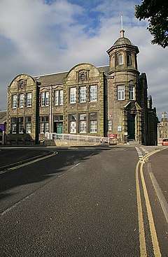 | |||
| Weensland Road, Mansfield House Hotel, Including Gatepiers | 55°25′53″N 2°45′47″W | Category C(S) | 51240 | | |||
| West Stewart Place, Former Kirklands Hotel | 55°25′52″N 2°47′14″W | Category C(S) | 51243 | | |||
| 63, 65 And 67 High Street, Former Hawick Co-Operative Store | 55°25′26″N 2°47′10″W | Category B | 34643 |  | |||
| 1 The Village, Slitrig Cottage, Including Boundary Wall | 55°25′11″N 2°47′19″W | Category C(S) | 34651 | | |||
| Kirkwynd Bridge Over Slitrig Water | 55°25′11″N 2°47′17″W | Category C(S) | 34656 | | |||
| 16, 18 And 20 Buccleuch Street | 55°25′17″N 2°47′29″W | Category C(S) | 34674 | | |||
| Buccleuch Street, Hawick Old Parish Church Hall | 55°25′15″N 2°47′36″W | Category C(S) | 34677 | | |||
| Dickson Street, Wilton Parish Church (Church Of Scotland) | 55°25′44″N 2°47′18″W | Category B | 34678 | | |||
| Buccleuch Road, Hawick Cottage Hospital Including Former X-Ray Block | 55°25′14″N 2°47′49″W | Category B | 34694 | | |||
| 1 St Mary's Place And 31 Drumlanrig Square | 55°25′13″N 2°47′22″W | Category C(S) | 34616 | | |||
| 3 Tower Knowe | 55°25′17″N 2°47′18″W | Category C(S) | 34621 | | |||
| 7 High Street, Bank Of Scotland | 55°25′19″N 2°47′18″W | Category B | 34637 | 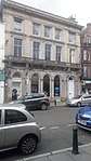 | |||
| Goldielands Tower | 55°24′27″N 2°49′33″W | Category B | 8379 | | |||
| 43 And 43A North Bridge Street | 55°25′38″N 2°47′04″W | Category B | 48106 | | |||
| 77 And 79 High Street | 55°25′27″N 2°47′08″W | Category C(S) | 51210 | | |||
| 2 Buccleuch Street | 55°25′17″N 2°47′24″W | Category C(S) | 34671 | | |||
| Wilton Park, Hawick Museum (Formerly Wilton Lodge) Including Toilet Block And Boundary Wall | 55°25′21″N 2°48′09″W | Category B | 34688 | | |||
| 30 High Street | 55°25′21″N 2°47′12″W | Category C(S) | 34633 | | |||
| Branxholme Castle | 55°23′46″N 2°50′50″W | Category A | 13686 | 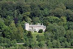 | |||
| Burnhead Tower | 55°26′31″N 2°46′05″W | Category B | 8376 | | |||
| 4 Howegate | 55°25′16″N 2°47′22″W | Category C(S) | 46410 | | |||
| 1 Dovemount Place, The Station Hotel | 55°25′42″N 2°47′07″W | Category C(S) | 51198 | | |||
| 23 Havelock Street | 55°25′48″N 2°47′16″W | Category B | 51201 | | |||
| 27 And 29 High Street | 55°25′21″N 2°47′14″W | Category C(S) | 51208 | | |||
| 8 High Street | 55°25′18″N 2°47′16″W | Category C(S) | 51211 | | |||
| 10 Liddesdale Road, Lynnwood Lodge | 55°24′56″N 2°47′30″W | Category C(S) | 51215 | | |||
| 1 North Bridge Street | 55°25′29″N 2°47′04″W | Category B | 51219 | 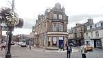 | |||
| 2, 4 And 6 North Bridge Street And 2 Croft Road, Including Stone Gatepiers | 55°25′32″N 2°47′05″W | Category C(S) | 51221 | | |||
| Roadhead, Norwood | 55°25′32″N 2°47′53″W | Category B | 51226 | | |||
| Rosalee Brae, Ladylaw | 55°25′34″N 2°47′34″W | Category B | 51227 | | |||
| Sunnyhill Road, East Langlands Lodge, Including Gatepier And Boundary Wall | 55°25′27″N 2°48′00″W | Category C(S) | 51231 | | |||
| 31, 33 And 35 High Street, Royal Bank Of Scotland | 55°25′22″N 2°47′14″W | Category C(S) | 34642 | | |||
| High Street, The Horse | 55°25′28″N 2°47′05″W | Category A | 34645 |  | |||
| Mill Path, Corn Mill | 55°25′14″N 2°47′10″W | Category B | 34660 | | |||
| 10 And 12 Buccleuch Street | 55°25′17″N 2°47′26″W | Category C(S) | 34672 | | |||
| Albert Bridge Over River Teviot | 55°25′20″N 2°47′25″W | Category B | 34675 | | |||
| 31 And 32 Commercial Road, Former Wilton Mills | 55°25′38″N 2°47′12″W | Category B | 34680 | | |||
| 1 And 3 High Street | 55°25′18″N 2°47′18″W | Category C(S) | 34635 | | |||
| 41 North Bridge Street | 55°25′37″N 2°47′03″W | Category C(S) | 48105 | | |||
| Dickson Street, Wilton Parish Church Hall | 55°25′45″N 2°47′19″W | Category B | 51197 | | |||
| Havelock Street, Silverbuthall Gatepiers | 55°25′48″N 2°47′15″W | Category C(S) | 51200 | | |||
| 19 High Street | 55°25′20″N 2°47′15″W | Category C(S) | 51203 | | |||
| 25 High Street | 55°25′21″N 2°47′15″W | Category C(S) | 51207 | | |||
| 47 High Street | 55°25′23″N 2°47′12″W | Category C(S) | 51209 | | |||
| 10 High Street | 55°25′18″N 2°47′16″W | Category C(S) | 51212 | | |||
| 9 Lockhart Place, Newbiggin | 55°25′21″N 2°46′52″W | Category C(S) | 51216 | | |||
| 36 Princes Street, Wilton Centre (Former Wilton Parish School) Including Boundary Walls And Gatepiers | 55°25′44″N 2°47′15″W | Category C(S) | 51225 | | |||
| 1 Silver Street And 9 Kirkstile, Including The Exchange Bar | 55°25′15″N 2°47′19″W | Category C(S) | 51229 | | |||
| Sunnyhill Road, East And West Langlands, Including Garden Pavilion, Boundary Wall And Gatepier | 55°25′29″N 2°48′00″W | Category C(S) | 51232 | | |||
| 1, 2, 3 And 4 Tower Dykeside (Former Tower Hotel) | 55°25′17″N 2°47′14″W | Category B | 51235 | | |||
| 5 And 6 Tower Knowe | 55°25′17″N 2°47′20″W | Category C(S) | 51239 | | |||
| 2 Howegate | 55°25′17″N 2°47′22″W | Category C(S) | 34646 | | |||
| Slitrig Crescent, Mill House, And 3 Mill Path, Including Boundary Wall | 55°25′14″N 2°47′12″W | Category C(S) | 34661 | | |||
| 2 And 3 Sandbed | 55°25′17″N 2°47′22″W | Category C(S) | 34667 | | |||
| Sandbed, Bridge House, Including Wall And Railings | 55°25′19″N 2°47′23″W | Category C(S) | 34669 | | |||
| Weensland Road, Weensland Mill Unit 13 (Former Weensland Mill Offices And Store) | 55°25′48″N 2°46′06″W | Category C(S) | 34685 | | |||
| Sandbed, Orrock Halls, Including Boundary Walls | 55°25′19″N 2°47′25″W | Category C(S) | 34689 | | |||
| 12 High Street | 55°25′19″N 2°47′15″W | Category B | 34628 |  | |||
| 34-44 High Street (Even Numbers), Hawick Town Hall | 55°25′21″N 2°47′10″W | Category A | 34634 | 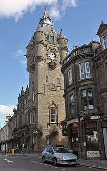 | |||
| 19 Howegate | 55°25′14″N 2°47′22″W | Category C(S) | 46423 | | |||
| Bourtree Place, Hawick Congregational Community Church And Halls | 55°25′32″N 2°46′59″W | Category C(S) | 51189 | | |||
| 2 And 4 Bourtree Place, Eastbank House | 55°25′28″N 2°47′04″W | Category C(S) | 51190 | | |||
| Brougham Place, Trinity Church, Including Session House, Vestry And Halls | 55°25′27″N 2°47′02″W | Category C(S) | 51192 | | |||
| Buccleuch Road, Parkview, Including Boundary Wall, Gate, Steps And Lamp Post | 55°25′06″N 2°48′10″W | Category C(S) | 51194 | | |||
| 16 And 18 High Street | 55°25′19″N 2°47′14″W | Category B | 51213 | 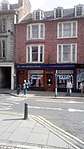 | |||
| 6 And 7 Mansfield Square, Former Wilton Parish Manse | 55°25′47″N 2°46′50″W | Category C(S) | 51217 | | |||
| Sunnyhill Road, Westwood, Including Outbuilding, Boundary Walls, Gates And Steps | 55°25′28″N 2°48′06″W | Category B | 51233 | | |||
| West Stewart Place, Ardenlea | 55°25′54″N 2°47′11″W | Category C(S) | 51242 | | |||
| 7 Slitrig Crescent | 55°25′11″N 2°47′14″W | Category C(S) | 34658 | | |||
| St George's Lane, Teviot And Roberton Church (Church Of Scotland) And Church Halls (Formerly St George's West Church) | 55°25′18″N 2°47′30″W | Category C(S) | 34676 | | |||
| Kirkstile, Former Tower Mill | 55°25′16″N 2°47′18″W | Category A | 34619 | 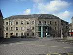 | |||
| 2 High Street | 55°25′18″N 2°47′16″W | Category C(S) | 34626 | | |||
| 9 High Street | 55°25′19″N 2°47′17″W | Category C(S) | 34638 | | |||
| Tentyfoot Tower | 55°23′46″N 2°50′50″W | Category A | 8397 | | |||
| 12 Howegate | 55°25′15″N 2°47′22″W | Category C(S) | 46414 | | |||
| 7 Howegate | 55°25′16″N 2°47′21″W | Category C(S) | 46419 | | |||
| 11 Howegate | 55°25′15″N 2°47′21″W | Category C(S) | 46421 | | |||
| 49 North Bridge Street | 55°25′38″N 2°47′04″W | Category B | 48109 | | |||
| Mansefield Road, Eastfield Mills | 55°25′45″N 2°46′46″W | Category B | 50813 | | |||
| 24 Commercial Road, Shorts Of Hawick | 55°25′30″N 2°47′19″W | Category C(S) | 50815 | | |||
| 21 High Street | 55°25′20″N 2°47′15″W | Category C(S) | 51204 | | |||
| Rear Of 21 High Street, Former William Beck's Stocking Shop | 55°25′20″N 2°47′17″W | Category C(S) | 51206 | | |||
| 152 Weensland Road, Heronhill Lodge, Including Gatepier | 55°25′46″N 2°46′07″W | Category C(S) | 51241 | | |||
| Loan, Former Drumlanrig Hospital | 55°25′09″N 2°47′25″W | Category B | 34663 | | |||
| 1 Sandbed | 55°25′17″N 2°47′22″W | Category C(S) | 34666 | | |||
| 10 Howegate | 55°25′15″N 2°47′22″W | Category C(S) | 46413 | | |||
| Victoria Road, Former Office To Turnbulls Finishing Works | 55°25′26″N 2°47′36″W | Category C(S) | 50814 | | |||
| 22 Bourtree Place, Hawick Conservative Club | 55°25′31″N 2°47′01″W | Category B | 51191 |  | |||
| 12 And 13 Oliver Place And 1 Croft Road | 55°25′31″N 2°47′05″W | Category C(S) | 51224 | |
Key
The scheme for classifying buildings in Scotland is:
- Category A: "buildings of national or international importance, either architectural or historic; or fine, little-altered examples of some particular period, style or building type."[1]
- Category B: "buildings of regional or more than local importance; or major examples of some particular period, style or building type, which may have been altered."[1]
- Category C: "buildings of local importance; lesser examples of any period, style, or building type, as originally constructed or moderately altered; and simple traditional buildings which group well with other listed buildings."[1]
In March 2016 there were 47,288 listed buildings in Scotland. Of these, 8 per cent were Category A, and 50 per cent were Category B, with the rest listed at Category C.[2]
Notes
- Sometimes known as OSGB36, the grid reference (where provided) is based on the British national grid reference system used by the Ordnance Survey.
• "Guide to National Grid". Ordnance Survey. Retrieved 12 December 2007.
• "Get-a-map". Ordnance Survey. Retrieved 17 December 2007. - Historic Environment Scotland assign a unique alphanumeric identifier to each designated site in Scotland, for listed buildings this always begins with "LB", for example "LB12345".
References
- All entries, addresses and coordinates are based on data from Historic Scotland. This data falls under the Open Government Licence
- "What is Listing?". Historic Environment Scotland. Retrieved 29 May 2018.
- Scotland's Historic Environment Audit 2016 (PDF). Historic Environment Scotland and the Built Environment Forum Scotland. pp. 15–16. Retrieved 29 May 2018.
This article is issued from Wikipedia. The text is licensed under Creative Commons - Attribution - Sharealike. Additional terms may apply for the media files.