List of listed buildings in Traquair, Scottish Borders
List
| Name | Location | Date Listed | Grid Ref. [note 1] | Geo-coordinates | Notes | LB Number [note 2] | Image |
|---|---|---|---|---|---|---|---|
| Kailzie Home Farm Including Farmhouse, Stables, Byres, Saw And Threshing Mills | 55°38′02″N 3°08′51″W | Category B | 15442 |  | |||
| Traquair Village, The Bield | 55°36′01″N 3°03′51″W | Category C(S) | 15433 | | |||
| The Glen, 1-3 (Inclusive) Fethan View | 55°35′25″N 3°06′38″W | Category C(S) | 49379 | | |||
| The Glen, Glen Farm Steading | 55°35′10″N 3°07′07″W | Category B | 49381 | | |||
| The Glen, Lion Gateway, Garden Features And Terraces | 55°35′09″N 3°06′54″W | Category A | 49386 | | |||
| The Glen, Old School House (Formerly Estate School And School Master's House) | 55°35′18″N 3°06′45″W | Category B | 49388 | | |||
| The Glen, Piggery | 55°35′08″N 3°07′10″W | Category B | 49390 | | |||
| The Glen, The Temple | 55°34′49″N 3°07′03″W | Category A | 49395 | | |||
| Traquair Mill House And Bothy | 55°35′57″N 3°04′06″W | Category B | 49405 | | |||
| Traquair Village, Bolt Cottage And Forester's Cottage | 55°36′05″N 3°03′48″W | Category C(S) | 49406 | | |||
| Kailzie, Dovecote | 55°38′09″N 3°08′32″W | Category A | 15439 | | |||
| Juniperbank Including Walled Garden, Boundary Walls And Gatepiers | 55°37′32″N 2°59′44″W | Category C(S) | 15421 | | |||
| Birkinshaw, Sundials And Carved Stones | 55°35′52″N 3°03′45″W | Category B | 15422 | | |||
| Traquair House Policies, Bear Gates And Avenue Head Cottages (4 Dwellings) | 55°36′19″N 3°04′16″W | Category A | 15430 | | |||
| Traquair Mill (Saw Mill And Associated Buildings) | 55°35′56″N 3°04′05″W | Category B | 15432 | | |||
| Cardrona Mains Farmhouse And Ice House | 55°38′23″N 3°06′39″W | Category C(S) | 15437 | | |||
| Kailzie, Former Game Larders | 55°38′09″N 3°08′31″W | Category C(S) | 49369 | | |||
| Kailzie, Scots Mill, Miller's House | 55°38′26″N 3°09′17″W | Category B | 49370 | | |||
| Kailzie, Walled Kitchen Garden, Glasshouses, Garden House (Formerly Head Gardener's House), Sundial, Gates And Railings | 55°38′05″N 3°08′42″W | Category B | 49371 | | |||
| The Glen, Factor's House | 55°35′06″N 3°07′05″W | Category B | 49378 | | |||
| The Glen, Garden Cottage | 55°35′10″N 3°07′02″W | Category B | 49380 | | |||
| Traquair House Policies, Craft Workshops | 55°36′25″N 3°03′54″W | Category B | 49398 | | |||
| The Glen, House And Service Wing | 55°35′09″N 3°06′55″W | Category A | 19746 |  | |||
| Haughhead, Viaduct | 55°37′07″N 3°02′55″W | Category B | 15423 | | |||
| Cardrona House, Lodge | 55°37′59″N 3°06′19″W | Category C(S) | 49365 | | |||
| Kirkburn, Former William Cree Memorial Church | 55°38′00″N 3°07′36″W | Category B | 49372 | | |||
| The Glen, Entrance Lodge, Gateway And Gates | 55°35′27″N 3°06′13″W | Category B | 49377 | | |||
| The Glen, Silo View And Nursery Cottages | 55°35′10″N 3°07′04″W | Category C(S) | 49392 | | |||
| The Glen, Swimming Pool And Terrace | 55°35′10″N 3°06′57″W | Category B | 49394 | | |||
| The Glen, Walled Garden Including Glasshouse And Shed Range, Steps, Gatepiers And Gates | 55°35′10″N 3°07′04″W | Category B | 49396 | | |||
| Traquair House, Exedra | 55°36′27″N 3°03′55″W | Category B | 49401 | | |||
| Traquair House Policies, Garden House (Now Brewer's House) And Outbuildings | 55°36′24″N 3°03′56″W | Category B | 49402 | | |||
| Traquair House, Tearoom (Former Coachman And Under-Gardener's Cottage) | 55°36′25″N 3°03′58″W | Category B | 49403 | | |||
| Kirkhouse Lodge | 55°35′30″N 3°04′39″W | Category B | 49653 | | |||
| Kailzie, Stable Courtyard | 55°38′07″N 3°08′37″W | Category B | 15441 | | |||
| Kailzie, Scots Mill | 55°38′26″N 3°09′17″W | Category B | 15420 | | |||
| Traquair House Including Wings, Terraces, Pavilions, Courtyard Screen Walls, Gatepiers, Railings And Gates | 55°36′30″N 3°03′50″W | Category A | 15429 | 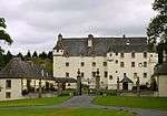 | |||
| The Glen, Bridge And Courtyard Entrance | 55°35′11″N 3°06′54″W | Category B | 49375 | | |||
| The Glen, K6 Telephone Kiosk | 55°35′12″N 3°07′00″W | Category B | 49384 | | |||
| The Glen, Kennels And House | 55°35′27″N 3°06′32″W | Category B | 49385 | | |||
| The Glen, Old Walled Garden Including Gatepiers And Gates | 55°35′12″N 3°07′08″W | Category C(S) | 49389 | | |||
| Traquair House Policies, Bridge On East Drive | 55°36′24″N 3°03′44″W | Category B | 49397 | | |||
| Traquair House Policies, Summerhouse | 55°36′21″N 3°03′57″W | Category A | 19391 | | |||
| Kailzie, Lodges, Gatepiers And Gates | 55°38′17″N 3°08′50″W | Category B | 15440 | | |||
| Knowebridge Over Quair Water | 55°36′08″N 3°04′02″W | Category B | 15431 | | |||
| Traquair Village, War Memorial | 55°36′03″N 3°03′51″W | Category B | 15434 | | |||
| Kailzie, East Lodge | 55°38′06″N 3°07′33″W | Category C(S) | 49368 | | |||
| The Glen, Hall | 55°35′09″N 3°07′06″W | Category C(S) | 49382 | | |||
| The Glen, House And Kennels Near Gentle's Wood (Feachan Castle) | 55°35′10″N 3°07′15″W | Category C(S) | 49383 | | |||
| Cardrona House | 55°37′47″N 3°06′23″W | Category B | 19747 | | |||
| Traquair Village, K6 Telephone Kiosk Near War Memorial | 55°36′04″N 3°03′49″W | Category B | 19113 | | |||
| Traquair Parish Church Including Churchyard | 55°35′24″N 3°04′49″W | Category B | 15419 | | |||
| Kirkbride House (Formerly Traquair Manse) And Outbuildings | 55°35′25″N 3°04′48″W | Category B | 15428 | | |||
| Howford House Including Gatepiers | 55°36′54″N 3°05′14″W | Category B | 49366 | | |||
| Innerleithen, Tweed Bridge | 55°36′46″N 3°03′34″W | Category C(S) | 49367 | | |||
| The Glen, Bridge Near Shrubbery | 55°35′12″N 3°07′03″W | Category C(S) | 49376 | | |||
| The Glen, Octagonal Dairy | 55°35′07″N 3°07′06″W | Category B | 49387 | | |||
| Traquair House, East Lodge Including Gatepiers, Gates And Boundary Walls | 55°36′25″N 3°03′40″W | Category B | 49399 | | |||
| Traquair House, Walled Garden | 55°36′23″N 3°03′59″W | Category B | 49404 | 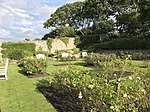 | |||
| Cardrona, Dovecote | 55°37′49″N 3°06′26″W | Category B | 15435 | | |||
| Kirkhouse, And Entrance Gatepiers | 55°35′26″N 3°04′42″W | Category B | 49373 | | |||
| The Glen, 1 And 2 Sawmill Cottages | 55°35′12″N 3°07′03″W | Category C(S) | 49391 | | |||
| The Glen, Stable Courtyard | 55°35′11″N 3°06′56″W | Category A | 49393 | | |||
| Traquair House Policies, Estate Office (Bear Cottage) | 55°36′26″N 3°03′57″W | Category B | 49400 | | |||
| Cardrona Mains, Cart Shed | 55°38′22″N 3°06′41″W | Category C(S) | 15438 | | |||
| The Glen, Anvil Cottage | 55°35′12″N 3°07′01″W | Category C(S) | 49374 | |
Key
The scheme for classifying buildings in Scotland is:
- Category A: "buildings of national or international importance, either architectural or historic; or fine, little-altered examples of some particular period, style or building type."[1]
- Category B: "buildings of regional or more than local importance; or major examples of some particular period, style or building type, which may have been altered."[1]
- Category C: "buildings of local importance; lesser examples of any period, style, or building type, as originally constructed or moderately altered; and simple traditional buildings which group well with other listed buildings."[1]
In March 2016 there were 47,288 listed buildings in Scotland. Of these, 8 per cent were Category A, and 50 per cent were Category B, with the rest listed at Category C.[2]
Notes
- Sometimes known as OSGB36, the grid reference (where provided) is based on the British national grid reference system used by the Ordnance Survey.
• "Guide to National Grid". Ordnance Survey. Retrieved 2007-12-12.
• "Get-a-map". Ordnance Survey. Retrieved 2007-12-17. - Historic Environment Scotland assign a unique alphanumeric identifier to each designated site in Scotland, for listed buildings this always begins with "LB", for example "LB12345".
References
- All entries, addresses and coordinates are based on data from Historic Scotland. This data falls under the Open Government Licence
- "What is Listing?". Historic Environment Scotland. Retrieved 29 May 2018.
- Scotland's Historic Environment Audit 2016 (PDF). Historic Environment Scotland and the Built Environment Forum Scotland. pp. 15–16. Retrieved 29 May 2018.
This article is issued from Wikipedia. The text is licensed under Creative Commons - Attribution - Sharealike. Additional terms may apply for the media files.