Ranga Reddy district
Ranga Reddy district, abbreviated as, R R district, formerly known as Hyderabad Rural, is one of the 33 districts in the Indian state of Telangana. The district headquarters is located at Shamshabad.[2][3] The district was named after the former deputy chief minister of the joint state of Andhra Pradesh, Konda Venkata Ranga Reddy.[4] The district shares boundaries with Nalgonda, Yadadri, Hyderabad, Medchal–Malkajgiri, Nagarkurnool, Mahabubnagar, Sangareddy and Vikarabad districts.
Ranga Reddy district Hyderabad Rural | |
|---|---|
District of Telangana | |
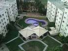 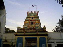  .jpg) Clockwise from top: Outer Ring Road, Chilkoor Balaji Temple, Rajiv Gandhi International Airport, View of Osman Sagar, Residential buildings at Miyapur | |
 Location in Telangana, India | |
| Coordinates: 17.3°N 78.1°E | |
| Country | |
| State | Telangana |
| Headquarters | Shamshabad |
| Founded | 15 August 1978 |
| Named for | Konda Venkata Ranga Reddy |
| Government | |
| • Type | Zilla Parishad (part), GHMC (part) |
| • Body | HMDA part |
| • MP | G. Ranjith Reddy |
| Area | |
| • Total | 5,031 km2 (1,942 sq mi) |
| Population (2011) | |
| • Total | 2,446,265 |
| • Rank | 2nd |
| • Density | 486/km2 (1,260/sq mi) |
| Languages | |
| • Official | Telugu, Urdu |
| Time zone | UTC+5:30 (IST) |
| PIN | 500 0XX, 501 5XX, 501 2XX, 501 1XX |
| Telephone code | 91-, 040, 08413, 08414, 08417 |
| Vehicle registration | TS–07, AP-28(old)[1] |
| District Collector | Amoy Kumar, IAS |
| District police officer | VC.Sajjanar, IPS, Cyberabad Commissioner, Mahesh Bhagwat, IPS, Rachakonda commissionerate |
| Website | rangareddy |
History
The district was formed in 1978 when it was split from Hyderabad district.[5][6] Originally named Hyderabad Rural district, it was renamed after Konda Venkata Ranga Reddy, a freedom fighter who fought for the independence of Telangana from the Nizams and who went on to become the deputy chief minister of Andhra Pradesh. In 2016, it was carved out during the district's reorganisation to create the new Vikarabad district and Medchal–Malkajgiri district.[4]
Geography
Ranga Reddy District occupies an area of approximately 7,500 square kilometres (2,900 sq mi).[7]
A freshwater reservoir, called Osman Sagar, Himayath Sagar, on the river Musi at Gandipet, is the prime drinking water source for the capital city of Hyderabad/Secunderabad.
Demographics
According to the 2011 census, Ranga Reddy District has a population of 2,446,265, of which 1,254,184 were males and 1,192,081 were females.[8]
Economy
- Medium-scale industries and Cement Corporation Of India (CCI)'s cement factories are established at Tandur.
- Another major company is Hyderabad Chemicals and Fertilizers, established at Moula-Ali in 1942.
In 2006 the Indian government named Ranga Reddy one of the country's 250 most backward districts (out of a total of 640).[9] It is one of the 33 districts in Telangana currently receiving funds from the Backward Regions Grant Fund Programme (BRGF).[9]
Administrative divisions
The district will have five revenue divisions: Chevella, Ibrahimpatnam, Rajendranagar, Kandukur and Shadnagar. They are sub-divided into 27 mandals.[2] Amoy Kumar IAS is the present collector of the district.[10] https://www.telangana.gov.in/contacts/district-officials
Mandals
The table below categorizes mandals into their respective revenue divisions in the district:[2]
| # | Chevella revenue division | Ibrahimpatnam revenue division | Kandukur revenue division | Rajendranagar revenue division | Shadnagar revenue division |
|---|---|---|---|---|---|
| 1 | Chevella | Abdullapuramet | Amangal | Gandipet | Chowderguda |
| 2 | Moinabad | Hayathnagar | Balapur | Rajendranagar | Farooqnagar |
| 3 | Shahbad | Ibrahimpatnam | Kandukur | Serilingampally | Keshampeta |
| 4 | Shankarpalle | Madgul | Kadthal | Shamshabad | Kondurg |
| 5 | Manchal | Maheswaram | Kothur | ||
| 6 | Yacharam | Talakondapalle | Nandigama | ||
| 7 | Saroornagar |
Assembly constituencies
There are 7 assembly constituencies in Ranga Reddy district. They are Chevella, Rajendranagar, L. B. Nagar, Shadnagar, Serlingampally, Ibrahimpatnam and Maheshwaram
See also
- List of districts in Telangana
References
- "District Codes". Government of Telangana Transport Department. Retrieved 4 September 2014.
- "Rangareddy district" (PDF). New Districts Formation Portal. Government of Telangana. Archived from the original (PDF) on 13 October 2016. Retrieved 26 March 2017.
- "Shamshabad to be Ranga Reddy district". Deccan Chronicle. 3 October 2016. Retrieved 30 March 2017.
- "Ranga Reddy district set to shrink". The Hindu. 3 October 2016. Retrieved 3 October 2016.
- Law, Gwillim (25 September 2011). "Districts of India". Statoids. Retrieved 11 October 2011.
- "Salient Features of Rangareddy District". Rangareddy District Official Website. Collectorate Rangareddy District. Archived from the original on 21 June 2012. Retrieved 19 December 2012.
- Srivastava, Dayawanti et al. (ed.) (2010). "States and Union Territories: Andhra Pradesh: Government". India 2010: A Reference Annual (54th ed.). New Delhi, India: Additional Director General, Publications Division, Ministry of Information and Broadcasting (India), Government of India. pp. 1111–1112. ISBN 978-81-230-1617-7.CS1 maint: extra text: authors list (link)
- http://www.rangareddy.telangana.gov.in/rangareddy/censusRangareddy.apo
- Ministry of Panchayati Raj (8 September 2009). "A Note on the Backward Regions Grant Fund Programme" (PDF). National Institute of Rural Development. Archived from the original (PDF) on 5 April 2012. Retrieved 27 September 2011.
- Mayabrahma, Roja (28 January 2020). "Suryapet collector Amoy Kumar transferred to Rangareddy". The Hans. Retrieved 19 February 2020.
| portal | |
|---|---|
| Dynasties |
|
| Districts |
|
| Commissionerates |
|
| Major cities | |
| Tourism |
|
| Municipal corporations | |
| Related lists |
|