List of Historic Sites of Japan (Yamagata)
National Historic Sites
As of 1 July 2019, twenty-eight Sites have been designated as being of national significance, including the Dewa Sendai Kaidō Nakayamagoe Pass, which spans the prefectural borders with Miyagi, and Mount Chōkai, which spans the prefectural borders with Akita.[2][3][4]
| Site | Municipality | Comments | Image | Coordinates | Type | Ref. |
|---|---|---|---|---|---|---|
| Ichinosaka Site 一ノ坂遺跡 Ichinosaka iseki |
Yonezawa | 37°54′35″N 140°04′54″E | 1 | 324 | ||
| Ichinosawa Caves 一の沢洞窟 Ichinosawa dōkutsu |
Takahata | 38°02′50″N 140°13′51″E | 1 | 311 | ||
| Inarimori Kofun 稲荷森古墳 Inarimori kofun |
Nan'yō | 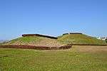 Inarimori Kofun |
38°02′23″N 140°09′26″E | 1 | 313 | |
| Ushū Kaidō 羽州街道 Ushū kaidō |
Kaminoyama | designation includes the sites of Narage-juku (楢下宿) and Kanayamagoe Pass (金山越) | 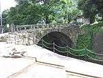 Ushū Kaidō |
38°05′49″N 140°18′43″E | 6 | 325 |
| Nobesawa Ginzan Site 延沢銀山遺跡 Nobesawa ginzan iseki |
Obanazawa | Edo-period silver mine opened in the Keichō era | 38°34′15″N 140°27′57″E | 6 | 317 | |
| Shimokomatsu Kofun Cluster 下小松古墳群 Shimokomatsu kofun-gun |
Kawanishi | 38°01′23″N 140°02′20″E | 1 | 3267 | ||
| Hibakoiwa Caves 火箱岩洞窟 Hibakoiwa dōkutsu |
Takahata | 38°03′02″N 140°12′56″E | 1 | 314 | ||
| Chidōkan 旧致道館 kyū-Chidōkan |
Tsuruoka | han school[5] | 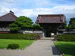 Chidōkan |
38°43′35″N 139°49′34″E | 4 | 298 |
| Old Abumiya Residence 旧鐙屋 kyū-Abumiya |
Sakata | the Abumiya family of rice brokers are mentioned in The Japanese Family Storehouse (日本永代蔵) by Saikaku[6][7] | 38°54′55″N 139°50′14″E | 4 | 316 | |
| Furushida-Higashi Site 古志田東遺跡 Furushida-Higashi iseki |
Yonezawa | 37°53′53″N 140°05′55″E | 1 | 3259 | ||
| Aterazawa Tateyama Castle Site 左沢楯山城跡 Aterazawa Tateyema-jō ato |
Ōe | 38°23′11″N 140°13′00″E | 2 | 00003618 | ||
| Yamagata Castle Site 山形城跡 Yamagata-jō ato |
Yamagata |  Yamagata Castle Site |
38°15′20″N 140°19′41″E | 2 | 318 | |
| Yama-dera 山寺 Yamadera |
Yamagata | also a Place of Scenic Beauty; immortalized in Bashō's haiku 閑さや岩にしみ入る蝉の声 "silence, penetrating into the rocks; the voice of a cicada"; in 1996 the Ministry of the Environment selected the cicadas of Yama-dera as one of the 100 Soundscapes of Japan[8] | 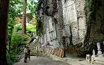 Yamadera |
38°18′50″N 140°26′06″E | 3 | 293 |
| Oguni Castle Site 小国城跡 Oguni-jō ato |
Tsuruoka | 38°34′03″N 139°37′56″E | 2 | 3345 | ||
| Matsugaoka Land Reclamation Area 松ヶ岡開墾場 Matsugaoka kaikonjō |
Tsuruoka | sericulture area developed in the early Meiji period by 3,000 former samurai of the Shōnai Domain; focus of the Matsugaoka Land Reclamation Area Memorial Museum (松ヶ岡開墾記念館)[9][10] | 38°42′01″N 139°53′10″E | 6 | 322 | |
| Uesugi Harunori Teaching Site 上杉治憲敬師郊迎跡 Uesugi Harunori keishi kōgei ato |
Yonezawa | at Haguro Jinja (羽黒神社) | 37°52′04″N 140°08′38″E | 4 | 295 | |
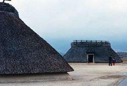
| Kinowanosaku Site 城輪柵跡 Kinowasaku ato |
Sakata | 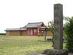 Kinowanosaku Site |
38°57′50″N 139°54′31″E | 2 | 294 | |
| Shinjō Domain Tozawa Clan Graves 新庄藩主戸沢家墓所 Shinjō-han-shu Tozawa-ke bosho |
Shinjō | 38°46′49″N 140°18′24″E | 7 | 320 | ||
| Nishinumata Site 西沼田遺跡 Nishinumata iseki |
Tendō | 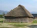 Nishinumata Site |
38°21′36″N 140°20′32″E | 1 | 319 | |
| Ōdachi Caves 大立洞窟 Ōdachi dōkutsu |
Takahata | 38°01′16″N 140°12′29″E | 1 | 312 | ||
| Shima Site 嶋遺跡 Shima iseki |
Yamagata | 38°17′03″N 140°19′08″E | 1 | 305 | ||
| Dōnomae Site 堂の前遺跡 Dōnomae iseki |
Sakata | 38°57′43″N 139°55′35″E | 2 | 310 | ||
| Hinata Caves 日向洞窟 Hinata dōkutsu |
Takahata | 38°01′55″N 140°12′15″E | 1 | 308 | ||
| Yonezawa Domain Uesugi Clan Graves 新庄藩主戸沢家墓所 Yonezawa-han-shu Uesugi-ke bosho |
Yonezawa |  Yonezawa Domain Uesugi Clan Graves |
37°54′54″N 140°05′29″E | 7 | 315 | |
| Mount Chōkai 鳥海山 Chōkaisan |
Yuza | designation includes areas of Yurihonjō and Nikaho in Akita Prefecture |  Mount Chōkai |
38°59′49″N 139°56′38″E | 3 | 00003566 |
| Dewa Sendai Kaidō Nakayamagoe Pass 出羽仙台街道中山越 Dewa Sendai kaidō Nakayamagoe |
Mogami | the road splits off from the Matsumaedō, subroute of the Ōshū Kaidō, at Yoshioka-juku (吉岡宿); path of Matsuo Bashō on his journey from Hiraizumi to Dewa Sanzan, as recounted in Oku no Hosomichi;[11] the designation includes an area of Ōsaki in Miyagi Prefecture | 38°44′15″N 140°36′59″E | 6 | 3095 | |
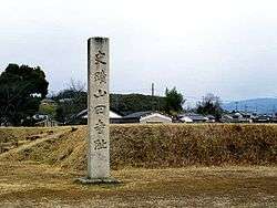
| Jion-ji Old Precinct 慈恩寺旧境内 Jionji kyū-keidai | Sagae | The temple built in A.D. 746.A valuable Buddharupa in the Heian Period is often possessed. |  | 38°24′37″N 140°15′03″E | ||
| Tateyama Castle Site 舘山城跡 Tateyama-jō ato | Yonezawa | 37°54′43″N 140°03′46″E |
Prefectural Historic Sites
As of 1 May 2018, thirty-two Sites have been designated as being of prefectural importance.[12][13]
| Site | Municipality | Comments | Image | Coordinates | Type | Ref. |
|---|---|---|---|---|---|---|
| Akutsu Kofun Cluster 安久津古墳群 Akutsu kofun-gun | Takahata | 38°00′28″N 140°12′02″E | ||||
| Amagasawa Earthen Altar 尼ヶ沢土壇 Amagasawa dodan | Kawanishi | 38°00′16″N 140°02′37″E | ||||
| Aratame Castle Site 新田目城跡 Aratame-jō ato | Sakata | 38°58′03″N 139°53′19″E | ||||
| Iidesan Water Conduit 飯豊山の穴堰 Iidesan no anazeki | Iide, Oguni | 147.7 m tunnel excavated through Mount Iide between 1798 and 1818[14] | 37°51′25″N 139°42′27″E | |||
| Ichirizuka 一里塚 ichirizuka | Sakata | 38°53′44″N 139°53′13″E | ||||
| Kakuchi Gakusha 格知学舎 Kakuchi gakusha | Tendō | 38°20′38″N 140°24′35″E | ||||
| Kakuniyama Stone Age Dwelling Sites 角二山石器時代住居跡群 Fukiura sekki-jidai jūkyo ato-gun | Ōishida | 38°35′20″N 140°22′23″E | ||||
| Kawashimayama Site 河島山遺跡 Kawashimayama iseki | Murayama | 38°29′10″N 140°21′13″E | ||||
| Kitadate Daigaku Grave 北楯大学墓 Kitadate Daigaku no haka | Shōnai | 38°47′31″N 139°58′27″E | ||||
| Former Yamagata Prefectural Assembly Building 旧山形県会仮議事堂 kyū-Yamagata-ken kaikarigijidō | Yamagata | 38°15′25″N 140°20′25″E | ||||
| Kyōgakura Sutra Mound 経ヶ倉山経塚 Kyōgakura kyōzuka | Sakata | 38°54′44″N 140°02′56″E | ||||
| Shimizu Castle Site 清水城跡 Shimizu-jō ato | Ōkura | 38°41′53″N 140°13′30″E | ||||
| Shimizumae Kofun Cluster 清水前古墳群 Shimizumae kofun-gun | Takahata | 38°00′30″N 140°13′49″E | ||||
| Jūgorigahara Battlefield 十五里ヶ原古戦場 Jūgorigahara ko-senjō | Tsuruoka | 38°44′49″N 139°47′06″E | ||||
| Sue Ware Kiln Site 須恵器窯跡 Sueki kama ato | Kaminoyama | 38°08′53″N 140°15′40″E | ||||
| Sue Ware Kiln Site 須恵器窯跡 Sueki kama ato | Tsuruoka | 38°42′59″N 139°42′54″E | ||||
| Sugesawa No.2 Kofun 菅沢古墳二号墳 Sugesawa kofun nigōfun | Yamagata | 38°13′39″N 140°16′17″E | ||||
| Takaseyama Kofun 高瀬山古墳 Takaseyama kofun | Sagae | 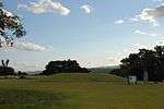 | 38°21′46″N 140°16′10″E | |||
| Takahara Kofun 高原古墳 Takahara kofun | Yamagata | 38°16′44″N 140°22′04″E | ||||
| Takeda Daizen no Tayū Nobikyo Grave 武田大膳太夫信清の墓 Takeda Daizen no Tayū Nobikyo no haka | Yonezawa | 37°54′05″N 140°06′05″E | ||||
| Tamagawa Jōmon Site 玉川縄文遺跡 Tamagawa Jōmon iseki | Tsuruoka | 38°42′20″N 139°56′23″E | ||||
| Tsuchiyagura Kofun Cluster 土矢倉古墳群 Tsuchiyagura kofun-gun | Kaminoyama | 38°09′47″N 140°18′01″E | ||||
| Tenjinmori Kofun 天神森古墳 Tenjinmori kofun | Kawanishi | 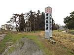 | 38°00′24″N 140°03′04″E | |||
| Naoe Kanetsugu Grave 直江兼続夫妻の墓 Naoe Kanetsugu fusai no haka | Yonezawa | graves of both husband and wife at Rinsen-ji (林泉寺) | 37°54′05″N 140°06′05″E | |||
| Nakamurahara Earthen Altar 中村原土壇 Nakamurahara dodan | Iide | 38°04′22″N 139°58′43″E | ||||
| Niirone Kofun Cluster 二色根古墳 Niirone kofun-gun | Nan'yō | 38°03′25″N 140°09′31″E | ||||
| Mount Haguro Southern Valley 羽黒山南谷 Hagurosan minami-dani | Tsuruoka | 38°42′06″N 139°58′56″E | ||||
| Harusame-an Site 春雨庵跡 Harusame-an ato | Kaminoyama |  | 38°09′23″N 140°16′08″E | |||
| Hirakata Fortified Residence Site 平形館跡 Hirakata tate ato | Tsuruoka | 38°46′31″N 139°53′56″E | ||||
| Fukiura Stone Age Site 吹浦石器時代遺跡 Fukiura sekki-jidai iseki | Yuza | 39°04′10″N 139°52′54″E | ||||
| Maruoka Castle Site 丸岡城跡及び加藤清正墓碑 Maruoka-jō ato oyobi Katō Kiyomasa bohi | Tsuruoka | designation includes the tombstone of Katō Kiyomasa | 38°40′51″N 139°49′54″E | |||
| Yagashiwa Kofun Cluster 谷柏古墳群 Yagashiwa kofun-gun | Yamagata | 38°12′40″N 140°17′10″E | ||||
Municipal Historic Sites
As of 1 May 2018 a further one hundred and sixty-five Sites have been designated as being of municipal importance.[15]

See also
References
- "Cultural Properties for Future Generations". Agency for Cultural Affairs. Retrieved 19 July 2019.
- 史跡名勝天然記念物 [Number of Monuments of Japan by Prefecture] (in Japanese). Agency for Cultural Affairs. 1 July 2019. Retrieved 19 July 2019.
- "Database of National Cultural Properties: 史跡名勝天然記念物 (史跡, 特別史跡 山形県 2県以上)" (in Japanese). Agency for Cultural Affairs. Archived from the original on 30 June 2019. Retrieved 19 July 2019.
- 国指定文化財一覧 [List of National Cultural Properties] (in Japanese). Yamagata Prefecture. Retrieved 19 July 2019.
- Motoyama Yukihito (1997). Proliferating Talent: Essays on Politics, Thought and Education in the Meiji Era. University of Hawaii Press. pp. 162 ff. ISBN 978-0-824-81846-3.
- 旧鐙屋 [Old Abumiya] (in Japanese). Sakata City. Retrieved 1 July 2012.
- Sargent, G. W. (translator) (1959). The Japanese Family Storehouse: or the Millionaires' Gospel Modernised. Cambridge University Press. p. 178.
- "100 Soundscapes of Japan" (in Japanese). Ministry of the Environment. Archived from the original on 8 June 2012. Retrieved 1 July 2012.
- 松ヶ岡開墾場 [Matsugaoka Land Reclamation Area] (in Japanese). Yamagata Prefecture. Retrieved 1 July 2012.
- "Matsu-ga-oka Land Reclamation Memorial Museum". Yamagata Prefectural Museum. Retrieved 1 July 2012.
- 出羽仙台街道中山越 [Dewa Sendai Kaidō Nakayamagoe Pass] (in Japanese). Miyagi Prefecture. Archived from the original on 11 January 2013. Retrieved 1 July 2012.
- 都道府県別指定等文化財件数(都道府県分) [Number of Prefectural Cultural Properties by Prefecture] (in Japanese). Agency for Cultural Affairs. 1 May 2018. Retrieved 19 July 2019.
- 県指定文化財一覧 [List of Prefectural Cultural Properties] (in Japanese). Yamagata Prefecture. Retrieved 19 July 2019.
- 飯豊山穴堰 [Iidesan Water Conduit] (in Japanese). Iide Town. Retrieved 1 July 2012.
- 都道府県別指定等文化財件数(市町村分) [Number of Municipal Cultural Properties by Prefecture] (in Japanese). Agency for Cultural Affairs. 1 May 2018. Retrieved 19 July 2019.
External links
| Wikimedia Commons has media related to National historic sites in Yamagata prefecture. |
(in Japanese) Cultural Properties in Yamagata Prefecture
This article is issued from Wikipedia. The text is licensed under Creative Commons - Attribution - Sharealike. Additional terms may apply for the media files.