List of Historic Sites of Japan (Iwate)
National Historic Sites
As of 1 July 2019, thirty Sites have been designated as being of national significance (including three *Special Historic Sites).[2][3]
| Site | Municipality | Comments | Image | Coordinates | Type | Ref. |
|---|---|---|---|---|---|---|
| *Chūson-ji Precinct 中尊寺境内 Chūson-ji keidai |
Hiraizumi | component of the UNESCO World Heritage Site Hiraizumi – Temples, Gardens and Archaeological Sites Representing the Buddhist Pure Land[4] |  Chūson-ji Precinct |
39°00′07″N 141°06′00″E | 3 | |
| *Muryōkō-in ruins 無量光院跡 Muryōkōin ato |
Hiraizumi | component of the UNESCO World Heritage Site Hiraizumi – Temples, Gardens and Archaeological Sites Representing the Buddhist Pure Land[4] |  Muryōkō-in ruins |
38°59′35″N 141°06′57″E | 3 | |
| *Mōtsū-ji Precinct and associated Chinjusha 毛越寺境内 附 鎮守社跡 Mōtsūji keidai tsuketari chinjūsha ato |
Hiraizumi | component of the UNESCO World Heritage Site Hiraizumi – Temples, Gardens and Archaeological Sites Representing the Buddhist Pure Land[4] | 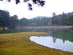 Mōtsū-ji Precinct |
38°59′26″N 141°06′56″E | 3 | |
| Ayaorishinden Site 綾織新田遺跡 Ayaorishinden iseki |
Tōno | Jōmon period settlement ruins | 39°19′01″N 141°17′56″E | 1 | ||
| Ōshū Kaidō 奥州街道 Ōshū Kaidō |
Ichinohe, Iwate | Edo period highway | 40°14′20″N 141°28′07″E | 6 | ||
| Shimofunato Shell Mound 下船渡貝塚 Shimofunato kaizuka |
Ōfunato | Jōmon period shell midden | 39°02′16″N 141°43′09″E | 1 | ||
| Tsunozuka Kofun 角塚古墳 Tsunozuka kofun |
Ōshū | Kofun period tumuli | 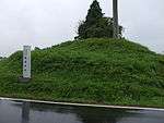 Tsunozuka Kofun |
39°08′29″N 141°05′37″E | 1 | |
| Kabayama Site 樺山遺跡 Kabayama iseki |
Kitakami | Jōmon period settlement | 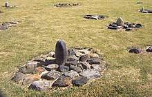 Kabayama Site |
39°14′32″N 141°07′48″E | 1 | |
| Hashino iron mining and smelting site 橋野高炉跡 Hashino kōro ato |
Kamaishi | oldest Western-style blast furnace in Japan, built in 1858; influenced the development of the Yawata Steel Works and for this reason a component of the UNESCO World Heritage Site Sites of Japan’s Meiji Industrial Revolution: Iron and Steel, Shipbuilding and Coal Mining[5][6] | 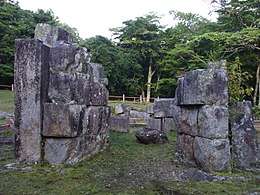 Hashino Blast Furnace Site |
39°20′36″N 141°40′57″E | 6 | |
| Kinkeizan 金鶏山 Kinkeizan |
Hiraizumi | component of the UNESCO World Heritage Site Hiraizumi – Temples, Gardens and Archaeological Sites Representing the Buddhist Pure Land[4] | 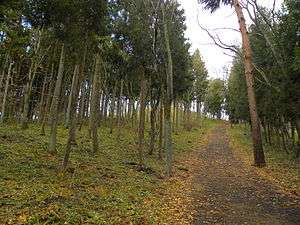 Kinkeizan |
38°59′36″N 141°06′33″E | 2,3 | |
| Kunohe Castle ruins 九戸城跡 Kunohe-jō ato |
Ninohe | Muromachi period castle ruins | 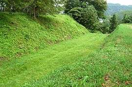 Kunohe Castle ruins |
40°16′04″N 141°18′11″E | 2 | |
| Goshono Site 御所野遺跡 Goshono iseki |
Ichinohe | submitted for inscription on the UNESCO World Heritage List as one of the Jōmon Archaeological Sites in Hokkaidō, Northern Tōhoku, and other regions[7][8] | 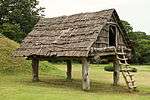 Goshono Site |
40°11′53″N 141°18′23″E | 1 | |
| Ezuriko Kofun Cluster 江釣子古墳群 Ezuriko kofun-gun |
Kitakami | Kofun period tumuli | 39°17′29″N 141°04′56″E | 1 | ||
| Former Residence of Takano Chōei 高野長英旧宅 Takano Chōei kyū-taku |
Ōshū | Bakumatsu period rangaku scholar residence | 39°08′30″N 141°08′28″E | 8 | ||
| Kunimisan temple ruins 国見山廃寺跡 Kunimisan Haiji ato |
Kitakami | Heian period temple ruins | 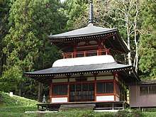 Kunimisan temple ruins |
39°15′48″N 141°08′32″E | 3 | |
| Honederamura Shōen ruins 骨寺村荘園遺跡 Honederamura shōen iseki |
Ichinoseki | Heian period estate ruins | 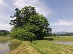 Honederamura Shōen Site |
38°58′54″N 140°57′06″E | 6 | |
| Sakiyama Shell Mound 崎山貝塚 Sakiyama kaizuka |
Miyako | Jōmon period shell midden | 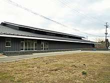 Sakiyama Shell Mound |
39°40′29″N 141°57′41″E | 1 | |
| Shiwa Castle ruins 志波城跡 Shiwa-jō ato |
Morioka | Heian period castle ruins | 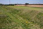 Shiwa Castle ruins |
39°41′08″N 141°06′22″E | 2 | |
| Morioka Castle 盛岡城跡 Morioka-jō ato |
Morioka | Edo period castle | 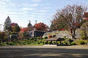 Morioka Castle |
39°42′02″N 141°09′04″E | 2 | |
| Ōsuzukami Site 大清水上遺跡 Ōsuzukami iseki |
Ōshū | Jōmon period settlement ruins | 39°06′47″N 140°57′14″E | 1 | ||
| Ōhora Shell Mound 大洞貝塚 Ōhora kaizuka |
Ōfunato | Jōmon period shell midden | 39°04′01″N 141°44′40″E | 1 | ||
| Takonoura Shell Mound 蛸ノ浦貝塚 Takonoura kaizuka |
Ōfunato | Jōmon period shell midden | 39°02′08″N 141°44′23″E | 1 | ||
| Takkoku-no-Iwaya 達谷窟 Takkoku-no-Iwaya |
Hiraizumi | Heian period Buddhist site | 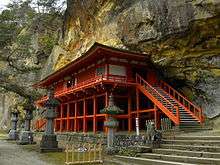 Takkoku-no-Iwaya |
38°58′08″N 141°03′29″E | 3 | |
| Isawa Castle Site 胆沢城跡 Isawa-jō ato |
Ōshū | Heian period castle ruins |  Isawa Castle Site |
39°10′51″N 141°08′07″E | 2 | |
| Nakazawahama Shell Mound 中沢浜貝塚 Nakazawahama kaizuka |
Rikuzentakata | Jōmon period shell midden | 38°57′16″N 141°41′39″E | 1 | ||
| Tokutan Castle ruins 徳丹城跡 Tokutan-jō ato |
Yahaba | Heian period castle ruins |  Tokutan Castle ruins |
39°36′28″N 141°10′21″E | 2 | |
| Nanbu-Date border mounds 南部領伊達領境塚 Nanbu-ryō Date-ryō |
Kitakami, Kanegasaki | Edo period border markers | 39°15′53″N 141°03′03″E | 2 | ||
| Hatten Site 八天遺跡 Hatten iseki |
Kitakami | Jōmon period settlement ruins | 39°19′44″N 141°09′26″E | 1 | ||
| Yanagi-no-Gosho and Sites of Hiraizumi 柳之御所・平泉遺跡群 Yanagi-no-Gosho - Hiraizumi iseki-gun |
Hiraizumi, Ōshū | designation includes the sites in Ōshū of Chōjagahara temple ruins (長者ヶ原廃寺跡) and Shirotoridate ruins (白鳥舘遺跡), which formed part of the original 2006 World Heritage nomination of "Hiraizumi - Cultural Landscape Associated with Pure Land Buddhist Cosmology"[9][10][11] |  Yanagi-no-Gosho |
38°59′37″N 141°07′09″E | 2 | |
| Tonomi Palisade ruins 鳥海柵跡 Tonomi-no-saku iseki |
Kanegasaki | Heian period castle ruins | 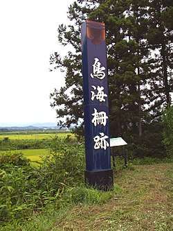 Tonomi Palisade ruins |
39°11′17″N 141°06′42″E | 2 |
Prefectural Historic Sites
As of 1 May 2018, thirty-seven Sites have been designated as being of prefectural importance.[12]
| Site | Municipality | Comments | Image | Coordinates | Type | Ref. |
|---|---|---|---|---|---|---|
| Noda Pit Dwelling Sites 野田竪穴住居跡群 Noda tateana jūkyo seki-gun | Noda | 40°06′12″N 141°48′10″E | ||||
| Dorota temple ruins 泥田廃寺跡 Dorota Haiji ato | Ichinoseki | 38°56′20″N 141°06′50″E | ||||
| Sekiya Cave Dwelling Site 関谷洞窟住居跡 Sekiya dōkutsu jūkyo ato | Ōfunato | 39°07′39″N 141°40′21″E | ||||
| Funakubo Cave 舟久保洞窟 Funakubo dōkutsu | Shiwa | 39°34′19″N 141°14′46″E | ||||
| Senba-Tsutsumi Pit Dwelling Site 仙波堤竪穴住居跡 Senba-Tsutsumi tateana jūkyo ato | Iwate | 39°57′36″N 141°10′49″E | ||||
| Imamatsu Pit Dwelling Site 今松竪穴住居跡 Imamatsu tateana jūkyo ato | Iwate | 39°57′43″N 141°09′17″E | ||||
| Ezomori Kofun えぞ森古墳 Ezomori kofun | Yahaba | 39°37′02″N 141°10′10″E | ||||
| Ukishima Kofun Cluster 浮島古墳群 Ukishima kofun-gun | Iwate | 39°56′23″N 141°08′50″E | ||||
| Nippei Site 新平遺跡 Nippei iseki | Yahaba | 39°19′07″N 141°03′49″E | ||||
| Myōgozawa Tile Excavation Site 明後沢古瓦出土地 Myōgozawa ko-kawara shutsudo-chi | Ōshū | 39°05′05″N 141°07′35″E | ||||
| Futago and Narita Ichirizuka 二子・成田一里塚 Futago・Narita Ichirizuka | Kitakami | 39°20′53″N 141°07′49″E | ||||
| Tannaisan Jinja Sutra Mound 丹内山神社経塚 Tannaisan Jinja kyōzuka | Hanamaki | 39°20′49″N 141°17′15″E | ||||
| Kaitori Shell Mound 貝鳥貝塚 Kaitori kaizuka | Ichinoseki | 38°47′02″N 141°10′20″E | ||||
| Shimokado Okahijirizuka 下門岡ひじり塚 Shimokado Okahijirizuka | Kitakami | 39°14′48″N 141°08′22″E | ||||
| Shizukuishi Kaidō Ichirizuka 雫石街道の一里塚 Shizukuishi Kaidō no ichirizuka | Takizawa, Shizukuishi | 39°42′03″N 141°03′00″E | ||||
| Ezo Ichirizuka 江曽一里塚 Ezo ichirizuka | Hanamaki | 39°27′07″N 141°08′19″E | ||||
| Isseki-Ichijō Sutra Mound 一石一字経塚 Isseki-Ichijō kyōzuka | Miyako | 39°38′54″N 141°56′03″E | ||||
| Matsusakigawa Ichirizuka 末崎川一里塚 Matsusakigawa ichirizuka | Morioka | 39°50′21″N 141°28′52″E | ||||
| Bishamondōhira Ichirizuka 毘沙門堂平一里塚 Bishamondōhira ichirizuka | Morioka | 39°50′48″N 141°25′50″E | ||||
| Tsukanosawa Ichirizuka 塚の沢一里塚 Tsukanosawa ichirizuka | Morioka | 39°49′40″N 141°23′06″E | ||||
| Ōhashi Ichirizuka 大橋一里塚 Ōhashi ichirizuka | Morioka | 39°49′40″N 141°19′38″E | ||||
| Onomatsu Ichirizuka 小野松一里塚 Onomatsu ichirizuka | Morioka | 39°46′01″N 141°09′57″E | ||||
| Niizuka Ichirizuka 新塚一里塚 Niizuka ichirizuka | Morioka | 39°52′22″N 141°11′03″E | ||||
| Ōtake temple ruins 大竹廃寺跡 Ōtake Haiji ato | Kitakami | 39°18′35″N 141°09′39″E | ||||
| Takahatake Ichirizuka 高畑一里塚 Takahatake ichirizuka | Morioka | 39°41′16″N 141°14′56″E | ||||
| Namiuchitōge Ichirizuka 浪打峠一里塚 Namiuchitōge ichirizuka | Ichinohe | 40°14′27″N 141°18′02″E | ||||
| Midō and Bahamatsu Ichirizuka 御堂・馬羽松一里塚 Midō・Bahamatsu ichirizuka | Ichinohe | 40°02′45″N 141°14′47″E | ||||
| Kuribayashi Copper Mint ruins 栗林銭座跡 Kuribayashi zeniza ato | Kamaishi | 39°20′07″N 141°49′22″E | ||||
| Kawarage Tile Kiln ruins 川原毛瓦窯跡 Kawarage kawara kama ato | Shiwa | 39°34′05″N 141°09′14″E | ||||
| Nakayama, Kotsunagi, and Kawazoko Ichirizuka 旧中山・小繋・川底一里塚 Nakayama・Kotsunagi・Kawazoko ichirizuka | Ichinohe | 40°08′41″N 141°17′59″E | ||||
| Ueda Ichirizuka 上田一里塚 Ueda ichirizuka | Morioka | 39°44′08″N 141°08′35″E | ||||
| Kouchikyū Ichirizuka 好地旧一里塚 Kouchikyū ichirizuka | Hanamaki | 39°29′30″N 141°08′35″E | ||||
| Tamagawa Iron Mine ruins 玉川鉄山跡 Tamagawa tetsuzan ato | Karumai | 40°16′53″N 141°34′33″E | ||||
| Ōzuchi Castle ruins 大槌城跡 Ōzuchi-jō ato | Ōtsuchi |  | 39°21′42″N 141°53′46″E | |||
| Tateishino Ichi Site 館石野I遺跡 Tateishino ichi iseki | Tanohata | 39°55′47″N 141°53′18″E | ||||
| Kuriki Iron Mine ruins 栗木鉄山跡 Kuriki tetsuzan ato | Sumita | 39°10′05″N 141°25′08″E | ||||
| Ōdate Settlement Site 大館町遺跡 Ōdate-chō ato | Morioka | inhabited from the late Jōmon to the Heian period | 39°42′55″N 141°06′50″E | |||
| Kuroyama Pit Dwelling Site 黒山の昔穴遺跡 Kuroyama no mukashi ana iseki | Kunohe | 40°14′15″N 141°23′27″E | ||||
Municipal Historic Sites
As of 1 May 2018, a further one hundred and ninety-four Sites have been designated as being of municipal importance.[13]

See also
- Cultural Properties of Japan
- Mutsu Province
- List of Places of Scenic Beauty of Japan (Iwate)
- List of Cultural Properties of Japan - paintings (Iwate)
References
| Wikimedia Commons has media related to National historic sites in Iwate prefecture. |
- "Cultural Properties for Future Generations". Agency for Cultural Affairs. Retrieved 19 July 2019.
- 史跡名勝天然記念物 [Number of Monuments of Japan by Prefecture] (in Japanese). Agency for Cultural Affairs. 1 July 2019. Retrieved 19 July 2019.
- "Database of National Cultural Properties: 史跡名勝天然記念物 (史跡, 特別史跡 北海道)" (in Japanese). Agency for Cultural Affairs. Archived from the original on 30 June 2019. Retrieved 19 July 2019.
- "Hiraizumi – Temples, Gardens and Archaeological Sites Representing the Buddhist Pure Land". UNESCO. Retrieved 14 June 2012.
- "Sites of Japan's Meiji Industrial Revolution: Iron and Steel, Shipbuilding and Coal Mining". UNESCO. Retrieved 19 July 2019.
- "Hashino Iron Mining and Smelting Site". Kyuyama. Archived from the original on 16 October 2013. Retrieved 14 June 2012.
- "Jômon Archaeological Sites in Hokkaidô, Northern Tôhoku, and other regions". UNESCO. Retrieved 13 June 2012.
- 「北海道・北東北を中心とした縄文遺跡群」の世界文化遺産登録をめざして [Towards World Heritage Inscription of "Jōmon Archaeological Sites in Hokkaidō, Northern Tōhoku, and other regions"] (in Japanese). Hokkaidō Government Board of Education. Archived from the original on 2013-05-08. Retrieved 13 June 2012.
- 長者ヶ原廃寺跡 [Chōjagahara Haiji Site] (in Japanese). Iwate Prefecture. Archived from the original on 20 April 2012. Retrieved 3 August 2012.
- 白鳥舘遺跡 [Shirotori-tate Site] (in Japanese). Iwate Prefecture. Archived from the original on 20 April 2012. Retrieved 3 August 2012.
- 世界遺産の概要 [World Heritage Site: summary] (in Japanese). Iwate Prefecture. Archived from the original on 13 June 2012. Retrieved 3 August 2012.
- 都道府県別指定等文化財件数(都道府県分) [Number of Prefectural Cultural Properties by Prefecture] (in Japanese). Agency for Cultural Affairs. 1 May 2018. Retrieved 15 June 2019.
- 都道府県別指定等文化財件数(市町村分) [Number of Municipal Cultural Properties by Prefecture] (in Japanese). Agency for Cultural Affairs. 1 May 2018. Retrieved 19 July 2019.
External links
- (in Japanese) Historic Sites of Iwate Prefecture
- (in Japanese) Cultural Properties in Iwate Prefecture
- (in Japanese) Map of Ichirizuka in Morioka City
This article is issued from Wikipedia. The text is licensed under Creative Commons - Attribution - Sharealike. Additional terms may apply for the media files.