Lethem, Guyana
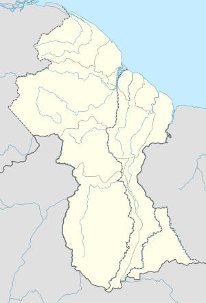
Lethem is a town in Guyana, located in the Upper Takutu-Upper Essequibo region, claimed by Venezuela as part of Bolívar state, who is localizated in the Guayana Esequiba.
Lethem | |
|---|---|
Town | |
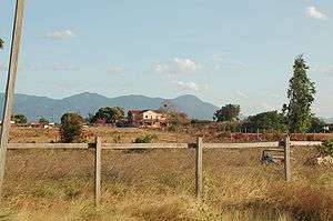 Lethem looking east | |
 Lethem | |
| Coordinates: 3°23′N 59°48′W | |
| Country | |
| Region State | Upper Takutu-Upper Essequibo (Bolívar state by Venezuela) |
| Population (2005) | |
| • Total | 1,158 |
| Time zone | UTC-4 |
It is named after Sir Gordon James Lethem, who was the Governor of British Guiana from 1941 to 12 April 1947. The city is populated by 1,158 inhabitants.
Demographics
The population of Guyana is varied and includes native Amerindian people who come from 9 original tribes in the savannahs. There is a mixture of Caribbean heritage as well as African. Few white people of Anglo-Saxon heritage live in Guyana and most are there visiting for scientific research in the savannahs or rain forest or visiting on Christian missionary campaigns. The language is an English-based Caribbean creole. Portuguese is also spoken, mainly by Brazilian immigrants, in addition to the many dialects of the Amerindian tribes.
Environment and economy
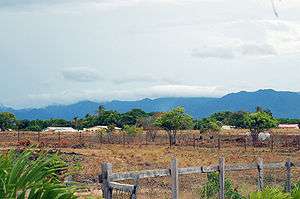
Lethem is part of the Guyanese Rupununi savannah where there are many vaqueiros (as spoken in the Portuguese language), or cowboys, and ranches. Local flora/fauna includes various types of cashew trees, both the fruit and nut varieties; mango trees and Coconut trees are also common. There is a cashew processing plant in St. Ignatius, one of the communities that are a part Lethem. There is also Culvert City, and New Culvert City, and there are several retail establishments throughout the township of Lethem. The Guyanese Dollar and, the Brazilian Reals, and in some stores, even U.S. currency is now accepted by merchants.
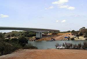
The Guyanese and Brazilian governments opened a bridge in 2009 [2] It cost US$5 million and was paid for by Brazil.[2]over the Takatu river just north of Lethem. The bridge links northern Brazil to the roads leading to the Atlantic coastal port of Georgetown, Guyana's capital, which is about 423 kilometers (263 miles) to the north.
Water is often drawn from hand dug wells although there is a community water supply, though it is slightly salted. Bottled, filtered water is common and easily available in stores, even in 5-gallon containers.
The area's other economic activities are plant and mineral extraction, and tourism. There is a rodeo event during Easter weekend, beginning on Saturday evening, at the Triple R Ranch, with many activities, including bull riding, "wild cow milking", greased pig competition, horse racing, horse rodeo (both bareback and with saddle) for men or women, and for cowgirls, "barrel" horse races. there's also plenty food, such as chicken- or pork-on-a-stick, sun-back beef, and hot dogs. There are also games, contests and entertainment, including a rope pull between vaqueros, and then vaqueras from Georgetown, competing with area Amerindians.
Airport
Lethem has an airport (IATA Code: LTM) that connects it to the capital, Georgetown with scheduled air service most weekdays. The airport has a single, 6,194 foot (1,888 meter) paved runway with instrument markings, but no lighting. The runway is oriented at 07/25. The approach to 07 is often flown in Brazilian airspace which begins less than 1 km from the threshold. Scheduled service is provided by Trans Guyana Airways, twice a day, via a twin engine, as well as by Air Services LTD. Persons traveling by air to Lethem should know that there are strict weight restrictions for luggage. Weight, depending on booking, could be restricted to less than 20 pounds. At present, all luggage is weighed when flying to or from Lethem, and there is a small charge per kilo of weight. The airport office is located just south of the western end of the runway.
Geography
Lethem lies on the Takutu River, which forms the border with Brazil, opposite the Brazilian town of Bonfim. Lethem is the capital of Region 9 and is a hub linking many of the surrounding villages to Georgetown. The Takutu River Bridge over the Takutu River was completed in 2009[2] It cost USD 5 million and was paid for by Brazil.[2] and is the only road link between the two countries. The newly built bridge is expected to bring Brazilian goods to the Georgetown harbor which would be faster than shipping through Brazilian ports. The town is approximately 280 feet (85 m) above sea level.
Climate
| Climate data for Lethem | |||||||||||||
|---|---|---|---|---|---|---|---|---|---|---|---|---|---|
| Month | Jan | Feb | Mar | Apr | May | Jun | Jul | Aug | Sep | Oct | Nov | Dec | Year |
| Average high °C (°F) | 33 (91) |
33 (91) |
33 (91) |
33 (91) |
32 (89) |
31 (87) |
31 (87) |
31 (88) |
33 (91) |
33 (92) |
33 (92) |
33 (91) |
32 (90) |
| Average low °C (°F) | 23 (73) |
23 (73) |
23 (73) |
23 (74) |
23 (74) |
23 (73) |
23 (73) |
23 (74) |
24 (75) |
24 (76) |
24 (75) |
23 (74) |
23 (74) |
| Average precipitation mm (inches) | 30 (1.2) |
36 (1.4) |
33 (1.3) |
140 (5.7) |
290 (11.5) |
300 (11.9) |
380 (14.8) |
240 (9.4) |
86 (3.4) |
58 (2.3) |
110 (4.3) |
33 (1.3) |
1,740 (68.5) |
| Source: Weatherbase [3] | |||||||||||||
References
- "Official Announcements". Archived from the original on 8 September 2016. Retrieved 28 July 2016.
- "Brazil and Guyana Inaugurate Border Bridge". sandiegouniontribune.com. THE ASSOCIATED PRESS. 2009-09-14. Retrieved 2015-09-08.
- "Weatherbase: Historical Weather for Lethem, Guyana". Weatherbase. 2011. Retrieved on November 24, 2011.
External links
| Wikivoyage has a travel guide for Lethem. |
- Looking south - January 11, 2007 - The Economist
- Commentary: Guyana and Brazil - Bridging for good times - February 13, 2009 - Caribbean Net News
- http://www.lib.utexas.edu/maps/americas/guyana_rel_1991.pdf