Upper Takutu-Upper Essequibo
Upper Takutu-Upper Esequibo (Region 9) is a region of Esequiban Guyana, a territory in dispute by Guyana and Venezuela. Venezuela claims the territory as part of Bolívar state. Unlike an elongated narrow section of the region who is located east of Essequibo river, which means is out of the dispute.
Upper Takutu-Upper Essequibo Region 9 | |
|---|---|
Administrative Region | |
 | |
 Flag | |
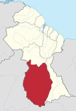 Map of Guyana showing Upper Takutu-Upper Essequibo region | |
| Country | |
| Regional Capital | Lethem |
| Area | |
| • Total | 57,750 km2 (22,300 sq mi) |
| Population (2012 census) | |
| • Total | 24,212 |
| • Density | 0.42/km2 (1.1/sq mi) |
| [2] | |
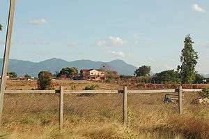
It borders the region of Potaro-Siparuni to the north, the region of East Berbice-Corentyne to the east and Brazil to the south and west. It contains the town of Lethem, and the villages of Aishalton, Nappi and Surama. It is also the largest region of Guyana. Sir John Noe was an English missionary there.
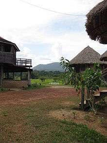
The Rupununi savannah is located between the Rupununi River and the Brazilian border.
Population
The Government of Guyana has administered three official censuses since the 1980 administrative reforms, in 1980, 1991 and 2002.[3] In 2012, the population of Upper Takutu-Upper Essequibo was recorded at 24,212 people.[4] Official census records for the population of the Upper Takutu-Upper Essequibo region are as follows:
- 2012 : 24,212
- 2002 : 19,387
- 1991 : 15,058
- 1980 : 12,873
Communities
List of communities (including name variants):
- Achiwib (Achiwuib Village)
- Adelair
- Aishalton (Aishalton Village)
- Ishalton
- Altora Village
- Ambrose Village
- Annai (Anwai)
- Apoteri
- Arakwai Outstation
- Atamadpau
- Awariwaunau (Awaruwaunawa)
- Basha Village
- Biloku
- Bon Success (Bom Sucesso)
- Burisanawa Village (Village Burisanawa)
- Cajueiro
- Dadanawa
- Good Hope
- Hart
- Hawkins Mission
- Hiawa
- Illimir Village
- Imprenza
- Isherton
- Jacaretinga (Jakaretinga)
- Johi (Johi Village)
- Kaibarupai Village
- Karanambo
- Karasabai (Karasabai Village)
- Kataliriwau Outstation
- Konashen
- Kotoewau
- Kumu Village
- Kurukuru-Baibari
- Kwaimatta (Kwaimatta Village, Kwaiwatta Village, Kwamatta)
- Kwatata (Quatata)
- Lethem (Lethen)
- Lumidpau
- MacDonald
- Macusi Village
- Mamir Pawa
- Manari
- Marakanata
- Mariwa Village
- Maruranau (Maruranawa, Marurawaunawa, Marurawaunawa Village)
- Massara (Massara Village)
- McTurk
- Melvilles Ranch
- Meritizero
- Moco-Moco (Moco-Moco Village)
- Moreiro (Moreiru)
- Mountain Point
- Mountain View
- Muriwa Village
- Nappi Village (Village Nappita)
- Parabara
- Paricaranal (Parikaranal)
- Parishara (Parishara Village)
- Patarinau
- Peropo
- Pilanawa (Pilinawa)
- Pirara
- Powisanau Village
- Pukasanta Village
- Sabernawau Village
- Saint Ignatius (Saint Ignatius Mission)
- Sand Creek Village
- Santa Fe (Santa Fe Ranch, Santa Fé Ranch)
- Sawariwau (Sawariwaunawa)
- Shea (Shea Village, Shoa)
- Shulinab (Shulinab Village, Village Shulinab)
- Sunnyside
- Surama (Surama Village, Surumatra)
- Tamtom (Tamton)
- Taruma (Taruma Village)
- Tiger Pond Village
- Tipuru (Tipuru Village)
- Toka (Toka Village,Tuka)
- Wai-Wai
- Waiwoi Village
- Wakadanawa
- Wakakulud (Wakakulud Village)
- Warimure
- Wariwau (Wariwiau Village)
- Waruma (Waruma Outstation)
- Wichabai
- Woweta (Woweta Village)
- Yakarinta
- Yepi Village (Yepu Village)
- Yupukari (Eupukari, Yupukarri)
References
- "Official Announcements". Archived from the original on 8 September 2016. Retrieved 28 July 2016.
- Macmillan Publishers (2009). "Administrative Regions - 8, 9 and 10". Macmillan Junior Atlas: Guyana. Oxford: Macmillan Caribbean. p. 37. ISBN 9780333934173.
- Beaie, Sonkarley Tiatun (19 September 2007). "Chapter 3: National Redistribution and Internal Migration" (PDF). 2002 Population and Housing Census - Guyana National Report. Bureau of Statistics. p. 51. Archived from the original (PDF) on 17 February 2012. Retrieved 29 August 2012.
- Beaie, Sonkarley Tiatun (19 September 2007). "National Population Trends: Size, Growth and Distribution" (PDF Download). 2002 Population and Housing Census - Guyana National Report. Bureau of Statistics. p. 25. Retrieved 29 August 2012.