Leeds, North Dakota
Leeds is a city in Benson County, North Dakota, United States. The population was 427 at the 2010 census.[5]
Leeds, North Dakota | |
|---|---|
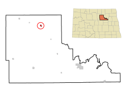 Location of Leeds, North Dakota | |
| Coordinates: 48°17′22″N 99°26′20″W | |
| Country | United States |
| State | North Dakota |
| County | Benson |
| Area | |
| • Total | 0.45 sq mi (1.17 km2) |
| • Land | 0.45 sq mi (1.17 km2) |
| • Water | 0 sq mi (0 km2) |
| Elevation | 1,512 ft (461 m) |
| Population | |
| • Total | 427 |
| • Estimate (2018)[3] | 468 |
| • Density | 950/sq mi (360/km2) |
| Time zone | UTC-6 (Central (CST)) |
| • Summer (DST) | UTC-5 (CDT) |
| ZIP code | 58346 |
| Area code(s) | 701 |
| FIPS code | 38-45580 |
| GNIS feature ID | 1029856[4] |
| Website | www |
Leeds was founded in 1887 and named after Leeds, England.[6] It was one of several sites along the Great Northern Railway's transcontinental route between Devils Lake and Minot that were named after places in England (the others were Berwick, Norwich, Penn, Rugby, Surrey, Tunbridge, and York).
Geography
Leeds is located at 48°17′22″N 99°26′20″W (48.289356, -99.438965).[7]
According to the United States Census Bureau, the city has a total area of 0.45 square miles (1.17 km2), all of it land.[1] The nearby Lake Ibsen is located approximately 1.5 miles (2.4 km) south-east of the city center.
Demographics
| Historical population | |||
|---|---|---|---|
| Census | Pop. | %± | |
| 1900 | 349 | — | |
| 1910 | 682 | 95.4% | |
| 1920 | 704 | 3.2% | |
| 1930 | 725 | 3.0% | |
| 1940 | 782 | 7.9% | |
| 1950 | 778 | −0.5% | |
| 1960 | 797 | 2.4% | |
| 1970 | 626 | −21.5% | |
| 1980 | 678 | 8.3% | |
| 1990 | 542 | −20.1% | |
| 2000 | 464 | −14.4% | |
| 2010 | 427 | −8.0% | |
| Est. 2018 | 468 | [3] | 9.6% |
| U.S. Decennial Census[8] 2018 Estimate[9] | |||
2010 census
As of the census[2] of 2010, there were 427 people, 201 households, and 118 families living in the city. The population density was 948.9 inhabitants per square mile (366.4/km2). There were 266 housing units at an average density of 591.1 per square mile (228.2/km2). The racial makeup of the city was 97.4% White, 1.4% Native American, and 1.2% from two or more races. Hispanic or Latino of any race were 0.9% of the population.
There were 201 households of which 23.9% had children under the age of 18 living with them, 52.7% were married couples living together, 5.0% had a female householder with no husband present, 1.0% had a male householder with no wife present, and 41.3% were non-families. 35.8% of all households were made up of individuals and 23.9% had someone living alone who was 65 years of age or older. The average household size was 2.12 and the average family size was 2.78.
The median age in the city was 50.6 years. 20.8% of residents were under the age of 18; 4.7% were between the ages of 18 and 24; 16.8% were from 25 to 44; 30.4% were from 45 to 64; and 27.2% were 65 years of age or older. The gender makeup of the city was 50.4% male and 49.6% female.
2000 census
As of the census of 2000, there were 464 people, 212 households, and 129 families living in the city. The population density was 1,018.8 people per square mile (389.5/km²). There were 282 housing units at an average density of 619.2 per square mile (236.7/km²). The racial makeup of the city was 96.98% White, 0.65% African American and 2.37% Native American.
There were 212 households out of which 28.3% had children under the age of 18 living with them, 51.4% were married couples living together, 8.0% had a female householder with no husband present, and 38.7% were non-families. 37.3% of all households were made up of individuals and 23.6% had someone living alone who was 65 years of age or older. The average household size was 2.19 and the average family size was 2.90.
In the city, the population was spread out with 25.4% under the age of 18, 3.7% from 18 to 24, 22.6% from 25 to 44, 24.1% from 45 to 64, and 24.1% who were 65 years of age or older. The median age was 44 years. For every 100 females, there were 96.6 males. For every 100 females age 18 and over, there were 93.3 males.
The median income for a household in the city was $31,953, and the median income for a family was $49,444. Males had a median income of $30,500 versus $17,279 for females. The per capita income for the city was $19,869. About 6.7% of families and 13.5% of the population were below the poverty line, including 17.6% of those under age 18 and 15.3% of those age 65 or over.
Great War Monument
Leeds is home to a Great War (World War I) monument that was constructed by the American War Mothers. The six foot tall granite pedestal bears a bronze tablet that lists seventy six men and two Red Cross nurses who participated in the conflict. The call to build the monument went out in the April 15, 1920 issue of the Leeds News. The November 18, 1920 issue of the Leeds News listed the names of the men and women who were to be placed on the monument in order to ensure that no names had been missed. The August 4, 1921 issue of the Leeds News announced that on August 7, 1921 the monument would be given its official dedication at 3 o'clock by the Great Northern right of way near the depot. It was written that "...this little spot has been seeded down and well cared for this summer and makes a pretty setting for the monument." The monument currently resides in Firemen's Memorial Park.
Climate
This climatic region is typified by large seasonal temperature differences, with warm to hot (and often humid) summers and cold (sometimes severely cold) winters. According to the Köppen Climate Classification system, Leeds has a humid continental climate, abbreviated "Dfb" on climate maps.[10]
References
- "US Gazetteer files 2010". United States Census Bureau. Archived from the original on 2012-07-02. Retrieved 2012-06-14.
- "U.S. Census website". United States Census Bureau. Retrieved June 14, 2012.
- "Population and Housing Unit Estimates". Retrieved June 16, 2019.
- "US Board on Geographic Names". United States Geological Survey. October 25, 2007. Retrieved January 31, 2008.
- "2010 Census Redistricting Data (Public Law 94-171) Summary File". American FactFinder. United States Census Bureau. Retrieved May 2, 2011.
- Wick, Douglas A. "Leeds (Benson County)". North Dakota Place Names. Retrieved 5 May 2011.
- "US Gazetteer files: 2010, 2000, and 1990". United States Census Bureau. 2011-02-12. Retrieved 2011-04-23.
- United States Census Bureau. "Census of Population and Housing". Retrieved June 17, 2014.
- "Population Estimates". United States Census Bureau. Retrieved June 16, 2019.
- Climate Summary for Leeds, North Dakota
External links
Municipalities and communities of Benson County, North Dakota, United States | ||
|---|---|---|
| Cities | 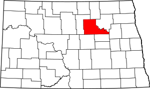 Map of North Dakota highlighting Benson County | |
| Townships |
| |
| CDP | ||
| Unincorporated communities | ||