Laudoha
Laudoha is a village in the Faridpur Durgapur CD block in the Durgapur subdivision of the Paschim Bardhaman district in the state of the West Bengal, India.
Laudoha | |
|---|---|
Village | |
 Laudoha Location in West Bengal, India  Laudoha Laudoha (India) | |
| Coordinates: 23°39′43.6″N 87°18′27.4″E | |
| Country | |
| State | West Bengal |
| District | Paschim Bardhaman |
| • Rank | 2,399 |
| Languages* | |
| • Official | Bengali, Hindi, English |
| Time zone | UTC+5:30 (IST) |
| Telephone/STD code | 0341 |
| Lok Sabha constituency | Asansol |
| Vidhan Sabha constituency | Pandaveswar |
| Website | paschimbardhaman |
Geography
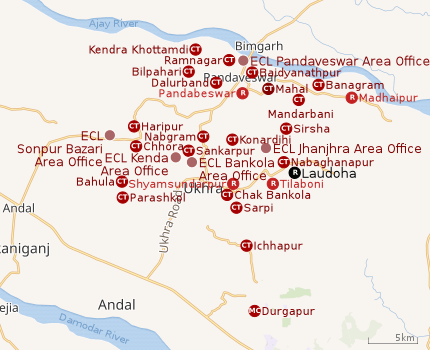 |
| Cities, towns and ECL Areas in the northern portion of Durgapur subdivision in Paschim Bardhaman district MC: Municipal Corporation, CT: census town, R: rural administrative centre Owing to space constraints in the small map, the actual locations in a larger map may vary slightly |
Location
The Asansol-Durgapur region is composed of undulating laterite region. This area lies between two mighty rivers – the Damodar and the Ajay. They flow almost parallel to each other in the region – the average distance between the two rivers is around 30 km. For ages the area was heavily forested and infested with plunderers and marauders. The discovery of coal in the 18th century led to industrialisation of the area and most of the forests have been cleared.[1]
Urbanisation
According to the 2011 census, 79.22% of the population of the Durgapur subdivision was urban and 20.78% was rural. The Durgapur subdivision has 1 municipal corporation at Durgapur and 38 (+1 partly) census towns (partly presented in the map alongside; all places marked on the map are linked in the full-screen map).[2]
Civic administration
Police station
Faridpur police station, located on Ukhra-Madaiganj Road, in Laudoha gram panchayat, has jurisdiction over parts of the Faridpur Durgapur CD block. The area covered is 106.56 km2 and the population covered is 94,603.[3][4]
CD block HQ
The headquarters of the Faridpur Durgapur CD block are located at Laudoha.[5]
Demographics
According to the 2011 Census of India, Laudoha had a total population of 2,399, of which 1,232 (51%) were males and 1,167 (49%) were females. Population in the age range 0-6 years was 257. The total number of literate persons in Laudoha was 1,660 (77.50% of the population over 6 years).[6]
*For language details see Faridpur Durgapur#Language and religion
Education
Laudoha K.T.B. Institution is a Bengali-medium coeducational institution established in 1963. It has facilities for teaching from class V to class XII. The school has 12 computers, a library with 2,000 books and a playground.[7]
Kalipur High School is a Bengali-medium coeducational institution established in 1907. It has facilities for teaching from class V to class X.[8]
Healthcare
Laudoha Rural Hospital, with 30 beds, at Laudoha, is the major government medical facility in the Faridpur Durgapur CD block. There are primary health centres at Lowapur, PO Ichhapur (with 6 beds) and Kantaberia, PO Dhabani (with 10 beds).[9][10]
References
- Chattopadhyay, Akkori, Bardhaman Jelar Itihas O Lok Sanskriti (History and Folk lore of Bardhaman District.), (in Bengali), Vol I, pp 14-15, Radical Impression. ISBN 81-85459-36-3
- "District Statistical Handbook 2014 Burdwan". Table 2.2, 2.4(a). Department of Statistics and Programme Implementation, Government of West Bengal. Retrieved 15 September 2018.
- "District Statistical Handbook 2014 Bardhaman". Tables 2.1, 2.2. Department of Statistics and Programme Implementation, Government of West Bengal. Retrieved 23 September 2018.
- "Asansol Durgapur Police Commissionerate". Find your police station. Asansol Durgapur Police. Retrieved 22 February 2017.
- "District Census Handbook: Barddhaman" (PDF). Map of Barddhaman with CD Block HQs and Police Stations (on the fourth page). Directorate of Census Operations, West Bengal, 2011. Retrieved 22 February 2017.
- "2011 Census – Primary Census Abstract Data Tables". West Bengal – District-wise. Registrar General and Census Commissioner, India. Retrieved 22 February 2017.
- "Laudoha K.T.B. Institution". Schools.org. Retrieved 12 June 2020.
- "Kalipur High School". Schools.org. Retrieved 12 June 2020.
- "Health & Family Welfare Department" (PDF). Health Statistics – Rural Hospitals. Government of West Bengal. Retrieved 12 May 2020.
- "Health & Family Welfare Department" (PDF). Health Statistics – Primary Health Centres. Government of West Bengal. Retrieved 12 May 2020.
Cities, towns and locations in Paschim Bardhaman district, West Bengal | |||||
|---|---|---|---|---|---|
| Cities, municipal and census towns | |||||
| Locations other than cities and towns |
| ||||
| Neighbourhoods in Asansol |
| ||||
| Related topics |
| ||||