Latehar district
Latehar district is one of the 24 districts of Jharkhand state in eastern India, and Latehar town is the administrative headquarters of this district. This district is part of Palamu division.
Latehar district | |
|---|---|
District of Jharkhand | |
 | |
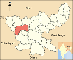 Location of Latehar district in Jharkhand | |
| Country | India |
| State | Jharkhand |
| Division | palamu |
| Headquarters | Latehar |
| Government | |
| • Deputy Commissioner | Zeeshan Qamar, IAS |
| • Lok Sabha constituencies | Chatra (shared with Chatra district) |
| • Vidhan Sabha constituencies | 2 Latehar (Vidhan Sabha constituency), Manika (Vidhan Sabha constituency) |
| • Latehar MLA | Baidyanath Ram, JMM |
| • Manika MLA | Ramchandra Singh, INC |
| Area | |
| • Total | 3,659.59 km2 (1,412.98 sq mi) |
| Population (2011) | |
| • Total | 726,978 |
| • Density | 200/km2 (510/sq mi) |
| Demographics | |
| • Literacy | 61.23 per cent |
| • Sex ratio | 964 |
| Time zone | UTC+05:30 (IST) |
| Website | http://latehar.nic.in/ |
Latehar district is situated on longitude 84° 31' E and 23° 44.4' N latitude. The area of the district is 3660 km², with a population of 726,978 (2011 census).
History
| Historical population | ||
|---|---|---|
| Year | Pop. | ±% p.a. |
| 1901 | 126,790 | — |
| 1911 | 140,616 | +1.04% |
| 1921 | 149,957 | +0.65% |
| 1931 | 167,407 | +1.11% |
| 1941 | 186,627 | +1.09% |
| 1951 | 201,560 | +0.77% |
| 1961 | 239,575 | +1.74% |
| 1971 | 299,630 | +2.26% |
| 1981 | 359,930 | +1.85% |
| 1991 | 457,040 | +2.42% |
| 2001 | 560,894 | +2.07% |
| 2011 | 726,978 | +2.63% |
| source:[1] | ||
The territory covered by the present district became a part of Palamu district, when it formed on 1 January 1928. Latehar district was created on 4 April 2001 by separating the erstwhile Latehar subdivision of Palamu district. It is currently a part of the Red Corridor.[2]
Administration
Blocks/Mandals
Latehar district consists of 9 blocks. The following are the list of the blocks in Latehar district:
Geography
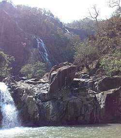
- Latehar district has two of the highest waterfalls in Jharkhand – Lodh Falls and Lower Ghaghri Falls, along with several others.[3]
- Betla National Park is located in this District.
Economy
In 2006 the Indian government named Latehar one of the country's 250 most backward districts (out of a total of 640).[4] It is one of the districts in Jharkhand currently receiving funds from the Backward Regions Grant Fund Programme (BRGF).[4]
Divisions
There are 9 development blocks, namely Latehar, Chandwa, Balumath, Bariyatu, Herhanj, Manika, Barwadih, Garu and Mahuadanr
There are two Vidhan Sabha constituencies in this district: Manika and Latehar. Both are part of Chatra Lok Sabha constituency.
Demographics
According to the 2011 census Latehar district has a population of 726,978.[5] Roughly equal to the nation of Bhutan[6] or the US state of Alaska.[7] This gives it a ranking of 499th in India (out of a total of 640).[5] The district has a population density of 200 inhabitants per square kilometre (520/sq mi) .[5] Its population growth rate over the decade 2001-2011 was 29.38%.[5] Latehar has a sex ratio of 964 females for every 1000 males,[5] and a literacy rate of 61.23%. Schedule Caste (SC) constitutes 21.3% while Schedule Tribe (ST) were 45.5% of total population.[5]
At the time of the 2011 Census of India, 40.6% of the population in the district spoke Hindi, 27.1% Sadri, 18.31% Kurukh, 6.04% Magahi and 5.09% Urdu as their first language.[8]
References
- Decadal Variation In Population Since 1901
- "83 districts under the Security Related Expenditure Scheme". IntelliBriefs. 11 December 2009. Retrieved 17 September 2011.
- "Showing all Waterfalls in India". World Waterfalls Database. Archived from the original on 25 August 2012. Retrieved 20 June 2010.
- Ministry of Panchayati Raj (8 September 2009). "A Note on the Backward Regions Grant Fund Programme" (PDF). National Institute of Rural Development. Archived from the original (PDF) on 5 April 2012. Retrieved 27 September 2011.
- "District Census 2011". Census2011.co.in. 2011. Retrieved 30 September 2011.
- US Directorate of Intelligence. "Country Comparison:Population". Retrieved 1 October 2011.
Bhutan 708,427
- "2010 Resident Population Data". U. S. Census Bureau. Archived from the original on 19 October 2013. Retrieved 30 September 2011.
Alaska 710,231
- 2011 Census of India, Population By Mother Tongue
External links
| Wikimedia Commons has media related to Latehar district. |
Places adjacent to Latehar district | |
|---|---|
| Topics |
| ||||||||||
|---|---|---|---|---|---|---|---|---|---|---|---|
| Divisions | |||||||||||
| Districts and divisions |
| ||||||||||
| Major cities | |||||||||||