Lapinig
Lapinig, officially the Municipality of Lapinig, is a 5th class municipality in the province of Northern Samar, Philippines. According to the 2015 census, it has a population of 13,020 people.[3]
Lapinig | |
|---|---|
| Municipality of Lapinig | |
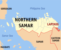 Map of Northern Samar with Lapinig highlighted | |
| |
.svg.png) Lapinig Location within the Philippines | |
| Coordinates: 12°18′54″N 125°18′07″E | |
| Country | |
| Region | Eastern Visayas (Region VIII) |
| Province | Northern Samar |
| District | 2nd District |
| Barangays | 15 (see Barangays) |
| Government | |
| • Type | Sangguniang Bayan |
| • Mayor | Ma. Luisa A. Menzon |
| • Vice Mayor | Flora S. Quilicol |
| • Congressman | Jose L. Ong Jr. |
| • Municipal Council | Councilors
|
| • Electorate | 8,603 voters (2019) |
| Area | |
| • Total | 57.30 km2 (22.12 sq mi) |
| Elevation | 4.0 m (13.1 ft) |
| Population (2015 census)[3] | |
| • Total | 13,020 |
| • Density | 230/km2 (590/sq mi) |
| • Households | 2,468 |
| Demonym(s) | Lapinignon |
| Economy | |
| • Income class | 5th municipal income class |
| • Poverty incidence | 48.54% (2015)[4] |
| • Revenue (₱) | 48,704,141.86 (2016) |
| Time zone | UTC+8 (PST) |
| ZIP code | 6411 |
| PSGC | |
| IDD : area code | +63 (0)55 |
| Climate type | tropical rainforest climate |
| Native languages | Waray Tagalog |
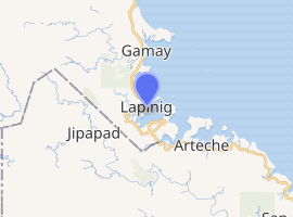
It is Northern Samar's boundary municipality with Eastern Samar on its coastal side in the Pacific. To the south, it is bounded by Arteche, to the west by Jipapad, to the northeast by the Pacific Ocean, and in the northwest by Gamay.
Barangays
Lapinig is politically subdivided into 15 barangays.
- Alang-alang
- Bagacay
- Cahagwayan
- Can Maria
- Can Omanio
- Imelda
- Lapinig del Sur (Poblacion)
- Lapinig del Norte (Poblacion)
- Lo-ok
- Mabini
- May-igot
- Palanas
- Pio Del Pilar
- Potong
- Potong Del Sur
Demographics
| Population census of Lapinig | ||
|---|---|---|
| Year | Pop. | ±% p.a. |
| 1960 | 7,610 | — |
| 1970 | 6,598 | −1.42% |
| 1975 | 7,426 | +2.40% |
| 1980 | 7,481 | +0.15% |
| 1990 | 8,232 | +0.96% |
| 1995 | 9,813 | +3.35% |
| 2000 | 10,798 | +2.07% |
| 2007 | 11,198 | +0.50% |
| 2010 | 11,744 | +1.75% |
| 2015 | 13,020 | +1.98% |
| Source: Philippine Statistics Authority[3][5][6][7] | ||
Climate
| Climate data for Lapinig, Northern Samar | |||||||||||||
|---|---|---|---|---|---|---|---|---|---|---|---|---|---|
| Month | Jan | Feb | Mar | Apr | May | Jun | Jul | Aug | Sep | Oct | Nov | Dec | Year |
| Average high °C (°F) | 27 (81) |
27 (81) |
28 (82) |
29 (84) |
30 (86) |
30 (86) |
30 (86) |
30 (86) |
29 (84) |
29 (84) |
28 (82) |
27 (81) |
29 (84) |
| Average low °C (°F) | 23 (73) |
22 (72) |
22 (72) |
23 (73) |
24 (75) |
24 (75) |
24 (75) |
24 (75) |
24 (75) |
24 (75) |
24 (75) |
23 (73) |
23 (74) |
| Average precipitation mm (inches) | 105 (4.1) |
67 (2.6) |
65 (2.6) |
53 (2.1) |
86 (3.4) |
129 (5.1) |
135 (5.3) |
113 (4.4) |
131 (5.2) |
163 (6.4) |
167 (6.6) |
162 (6.4) |
1,376 (54.2) |
| Average rainy days | 17.6 | 13.2 | 15.5 | 14.9 | 19.6 | 24.3 | 26.6 | 25.4 | 24.9 | 25.4 | 22.9 | 20.9 | 251.2 |
| Source: Meteoblue [8] | |||||||||||||
References
- "Municipality". Quezon City, Philippines: Department of the Interior and Local Government. Retrieved 31 May 2013.
- "Province: Northern Samar". PSGC Interactive. Quezon City, Philippines: Philippine Statistics Authority. Retrieved 12 November 2016.
- Census of Population (2015). "Region VIII (Eastern Visayas)". Total Population by Province, City, Municipality and Barangay. PSA. Retrieved 20 June 2016.
- "PSA releases the 2015 Municipal and City Level Poverty Estimates". Quezon City, Philippines. Retrieved 12 October 2019.
- Census of Population and Housing (2010). "Region VIII (Eastern Visayas)". Total Population by Province, City, Municipality and Barangay. NSO. Retrieved 29 June 2016.
- Censuses of Population (1903–2007). "Region VIII (Eastern Visayas)". Table 1. Population Enumerated in Various Censuses by Province/Highly Urbanized City: 1903 to 2007. NSO.
- "Province of Northern Samar". Municipality Population Data. Local Water Utilities Administration Research Division. Retrieved 17 December 2016.
- "Lapinig, Northern Samar: Average Temperatures and Rainfall". Meteoblue. Retrieved 6 January 2019.
External links
- Lapinig Profile at PhilAtlas.com
- Philippine Standard Geographic Code
- Philippine Census Information
- Local Governance Performance Management System
Places adjacent to Lapinig | |
|---|---|
Catarman (capital) | |
| Municipalities | |
This article is issued from Wikipedia. The text is licensed under Creative Commons - Attribution - Sharealike. Additional terms may apply for the media files.