Lope de Vega, Northern Samar
Lope de Vega, officially the Municipality of Lope de Vega, is a 4th class municipality in the province of Northern Samar, Philippines. According to the 2015 census, it has a population of 14,687 people.[3]
Lope de Vega | |
|---|---|
| Municipality of Lope de Vega | |
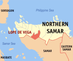 Map of Northern Samar with Lope de Vega highlighted | |
| |
.svg.png) Lope de Vega Location within the Philippines | |
| Coordinates: 12°17′54″N 124°37′26″E | |
| Country | |
| Region | Eastern Visayas (Region VIII) |
| Province | Northern Samar |
| District | 1st District |
| Named for | Lope de Vega |
| Barangays | 22 (see Barangays) |
| Government | |
| • Type | Sangguniang Bayan |
| • Mayor | Ana T. Palloc |
| • Vice Mayor | Bobby C. Saludario |
| • Congressman | Paul R. Daza |
| • Municipal Council | Councilors
|
| • Electorate | 11,128 voters (2019) |
| Area | |
| • Total | 280.00 km2 (108.11 sq mi) |
| Elevation | 30.2 m (99.1 ft) |
| Population (2015 census)[3] | |
| • Total | 14,687 |
| • Density | 52/km2 (140/sq mi) |
| • Households | 2,808 |
| Economy | |
| • Income class | 4th municipal income class |
| • Poverty incidence | 56.85% (2015)[4] |
| • Revenue (₱) | 78,528,263.29 (2016) |
| Time zone | UTC+8 (PST) |
| ZIP code | 6403 |
| PSGC | |
| IDD : area code | +63 (0)55 |
| Climate type | tropical rainforest climate |
| Native languages | Waray Tagalog |
| Website | www |
It is bordered in the north by Catarman and Mondragon in the east and the province of Samar in the south.
Lope de Vega was created under Batas Pambansa Blg. 69 on May 1, 1980, separating 22 barangays from Catarman. It is named after the Baroque Spanish playwright and poet Lope de Vega.
Barangays
Lope De Vega is politically subdivided into 22 barangays.
- Bayho
- Bonifacio
- Cagamesarag
- Cag-aguingay
- Curry
- Gebonawan
- Gen. Luna
- Getigo
- Henaronagan
- Lope De Vega (Poblacion)
- Lower Caynaga
- Maghipid
- Magsaysay
- Osmeña
- Paguite
- Roxas
- Sampaguita
- San Francisco
- San Jose
- San Miguel
- Somoroy
- Upper Caynaga
Demographics
| Population census of Lope de Vega | ||
|---|---|---|
| Year | Pop. | ±% p.a. |
| 1990 | 9,254 | — |
| 1995 | 11,947 | +4.90% |
| 2000 | 11,754 | −0.35% |
| 2007 | 12,173 | +0.48% |
| 2010 | 13,542 | +3.95% |
| 2015 | 14,687 | +1.56% |
| Source: Philippine Statistics Authority[3][5][6][7] | ||
Climate
| Climate data for Lope de Vega, Northern Samar | |||||||||||||
|---|---|---|---|---|---|---|---|---|---|---|---|---|---|
| Month | Jan | Feb | Mar | Apr | May | Jun | Jul | Aug | Sep | Oct | Nov | Dec | Year |
| Average high °C (°F) | 27 (81) |
28 (82) |
29 (84) |
30 (86) |
31 (88) |
30 (86) |
29 (84) |
29 (84) |
29 (84) |
29 (84) |
29 (84) |
28 (82) |
29 (84) |
| Average low °C (°F) | 22 (72) |
22 (72) |
22 (72) |
22 (72) |
24 (75) |
24 (75) |
24 (75) |
24 (75) |
24 (75) |
24 (75) |
23 (73) |
23 (73) |
23 (74) |
| Average precipitation mm (inches) | 84 (3.3) |
59 (2.3) |
58 (2.3) |
55 (2.2) |
93 (3.7) |
133 (5.2) |
149 (5.9) |
125 (4.9) |
155 (6.1) |
165 (6.5) |
140 (5.5) |
136 (5.4) |
1,352 (53.3) |
| Average rainy days | 18.1 | 13.6 | 15.8 | 16.1 | 21.7 | 25.5 | 26.6 | 25.1 | 24.8 | 25.8 | 22.7 | 20.1 | 255.9 |
| Source: Meteoblue [8] | |||||||||||||
Transportation
Lope de Vega is served by buses, jeepneys, and van-for-hire with service to Catarman, Calbayog City and to Tacloban City. There are ships also that travels from Calbayog City to Cebu City. The town has no airport, but is accessible via nearby Catarman National Airport and Calbayog Airport.
References
- "Municipality". Quezon City, Philippines: Department of the Interior and Local Government. Retrieved 31 May 2013.
- "Province: Northern Samar". PSGC Interactive. Quezon City, Philippines: Philippine Statistics Authority. Retrieved 12 November 2016.
- Census of Population (2015). "Region VIII (Eastern Visayas)". Total Population by Province, City, Municipality and Barangay. PSA. Retrieved 20 June 2016.
- "PSA releases the 2015 Municipal and City Level Poverty Estimates". Quezon City, Philippines. Retrieved 12 October 2019.
- Census of Population and Housing (2010). "Region VIII (Eastern Visayas)". Total Population by Province, City, Municipality and Barangay. NSO. Retrieved 29 June 2016.
- Censuses of Population (1903–2007). "Region VIII (Eastern Visayas)". Table 1. Population Enumerated in Various Censuses by Province/Highly Urbanized City: 1903 to 2007. NSO.
- "Province of Northern Samar". Municipality Population Data. Local Water Utilities Administration Research Division. Retrieved 17 December 2016.
- "Lope de Vega, Northern Samar : Average Temperatures and Rainfall". Meteoblue. Retrieved 6 January 2019.
External links
- Lope de Vega Profile at PhilAtlas.com
- Philippine Standard Geographic Code
- Philippine Census Information
- Local Governance Performance Management System
Places adjacent to Lope de Vega, Northern Samar | |
|---|---|
Catarman (capital) | |
| Municipalities | |