Lantau Peak
Lantau Peak or Fung Wong Shan (Chinese: 鳳凰山, literally "Phoenix Mountain") is the second highest peak in Hong Kong and the highest point on Lantau Island, with a height of 934 metres (3,064 ft) above sea level.[1] It is famous for the sunrise scenery viewed from the summit.[2]
| Lantau Peak | |
|---|---|
| 鳳凰山 | |
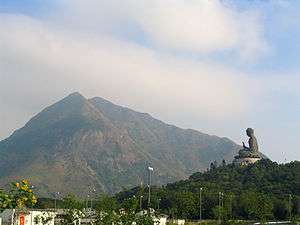 The Lantau Peak rises high above the Tian Tan Buddha. | |
| Highest point | |
| Elevation | 934 m (3,064 ft) |
| Prominence | 934 m (3,064 ft) |
| Coordinates | 22°14′59.17″N 113°55′16.69″E |
| Geography | |
 Lantau Peak Location of Lantau Peak in Hong Kong | |
| Location | Lantau Island, |
Name origin
The mountain is actually made up of a pair of peaks, one is known as "Fung Shan" (male phoenix mountain) and the other is "Wong Shan" (female phoenix mountain), together they form "Fung Wong Shan".
Geology
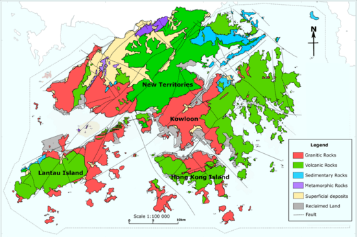
Lantau Peak is formed by Volcanic rocks, including porphyritic rhyolites,[3] like many of the tallest mountains in Hong Kong, such as Tai Mo Shan. Some shorter mountains in Hong Kong are formed by older Granitic rocks.
Climate
Lantau Peak is located in central Lantau Island, with an elevation of 934 meters above sea level (23 metres shorter than Tai Mo Shan, Hong Kong's highest peak).[1] Under the Köppen climate classification, Lantau Peak features a subtropical highland climate. Due to its elevation, strong winds and fog occur throughout the year. Winter is cold with temperatures often dipping below 0 ° C; summer is warm with temperatures reaching tops of 18-22 ° C; spring is cool and humid; autumn is cool and dry. Because there is no weather station at the top of Lantau Peak (934m), the Ngong Ping Weather Station of the Hong Kong Observatory (593m)[4] can be used as reference for the temperature at the summit.
| Climate data for Lantau Peak | |||||||||||||
|---|---|---|---|---|---|---|---|---|---|---|---|---|---|
| Month | Jan | Feb | Mar | Apr | May | Jun | Jul | Aug | Sep | Oct | Nov | Dec | Year |
| Average high °C (°F) | 8.3 (46.9) |
10.2 (50.4) |
11.9 (53.4) |
14.2 (57.6) |
16.6 (61.9) |
17.8 (64.0) |
18.5 (65.3) |
19.2 (66.6) |
18.7 (65.7) |
16.6 (61.9) |
13.5 (56.3) |
10.0 (50.0) |
14.6 (58.3) |
| Daily mean °C (°F) | 4.9 (40.8) |
7.2 (45.0) |
9.0 (48.2) |
13.1 (55.6) |
14.8 (58.6) |
16.3 (61.3) |
16.9 (62.4) |
17.1 (62.8) |
16.3 (61.3) |
13.8 (56.8) |
10.6 (51.1) |
6.8 (44.2) |
12.2 (54.0) |
| Average low °C (°F) | 2.3 (36.1) |
4.9 (40.8) |
6.8 (44.2) |
10.0 (50.0) |
13.1 (55.6) |
14.7 (58.5) |
15.3 (59.5) |
15.3 (59.5) |
14.5 (58.1) |
11.9 (53.4) |
8.4 (47.1) |
4.2 (39.6) |
10.1 (50.2) |
| Source: Climate Data for Lantau Peak — Hong Kong Observatory | |||||||||||||
Access
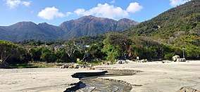
Lantau Peak is one of the most popular hiking spots in Hong Kong and can be reached by the Lantau Trail. At the foot of Lantau Peak, a tourist spot opened in 2005, called the Wisdom Path (心經簡林) can be found.[5]
To catch a view of the famous Lantau Peak sunrise, many hikers begin their climb from the Youth Hostel near Ngong Ping before dawn.
References
- "Lantau South". www.afcd.gov.hk. Retrieved 18 September 2019.
- "Lantau Peak | Hong Kong Tourism Board". www.discoverhongkong.com. Retrieved 18 September 2019.
- "Lantau Volcanic Group (undifferentiated) - Jlu". www.cedd.gov.hk. Retrieved 26 April 2020.
- "Variation of Wind Direction and Speed". www.hko.gov.hk. Retrieved 18 September 2019.
- "Tourism Commission - Completed". www.tourism.gov.hk. Retrieved 18 September 2019.
See also
| Wikimedia Commons has media related to Lantau Peak. |
| 900 meters or more | |
|---|---|
| 800 to 899 meters | |
| 700 to 799 meters | |
| 600 to 699 meters |
|
| 500 to 599 meters |
|
| 400 to 499 meters (excerpt) |
|
| 300 to 399 meters (excerpt) |
|
| 200 to 299 meters (excerpt) |
|
| 100 to 199 meters (excerpt) |
|
| 99 meters or less (excerpt) |
|
| Collectively |
|