Castle Peak, Hong Kong
Castle Peak (Chinese: 青山, sometimes transcribed Tsing Shan)[1] or Pui To Shan (杯渡山) is a 583 m high peak in the western New Territories of Hong Kong.
| Castle Peak, Hong Kong | |
|---|---|
| 青山 | |
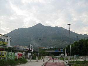 View of Castle Peak | |
| Highest point | |
| Elevation | 583 m (1,913 ft) Hong Kong Principal Datum |
| Coordinates | 22°23′18.35″N 113°57′11.63″E |
| Geography | |
 Castle Peak, Hong Kong Location of Castle Peak in Hong Kong | |
| Location | |
In contrast to its Chinese name, which means green hill, Castle Peak is notorious for its severe loss of vegetation and weathering of its granite surface.[2]
The area to the west of the hill is an industrial area with several power plants owned by CLP (Castle Peak Power Station and Black Point Power Station). It is also the old name of Tuen Mun during early British rule before starting development of Tuen Mun New Town. In early proposal of the development, the new town was named Castle Peak New Town.
Castle Peak Hinterland
Most areas north of the mountain and west of the mountain are commonly known as the Castle Peak Hinterland.[3] Much of this large rocky Hinterland is a designated firing range used by the People's Liberation Army[4] and police forces in Hong Kong, and is named the "Tsing Shan Firing Range".[5] Warnings are issued to the public before live military exercises are carried out. Sometimes the Fire Range is open to the public, but before venturing into the Hinterland, it is best to confirm the days on which the Hinterland is open to the public by searching for "fire range" in the Hong Kong Government press release website. The press releases concerning the fire range for any given month is typically released one week prior to the start of that month. Generally speaking, Sundays and Public Holidays are open days.
There are many hills that are considered sub-peaks of Castle Peak within this Hinterland. Mountains Kon Shan and Por Lo Shan are frequently visited by hikers because the area's terrain has been compared to that of the Grand Canyon in the US, but in a smaller scale.[6]
Note that while the summit of Castle Peak is not part of the Hinterland and is accessible daily, some of the routes leading up to the summit, namely from the north and west, may be closed because of military exercises on select days.
Castle Peak is unique in that it is among the few prominent mountains in Hong Kong which are not inside a Country Park.
History
The name Pui To Shan was associated with a Buddhist monk Pui To Sim Shi (杯渡禪師). In Cantonese, Pui means "cup", To means "water-crossing", Sim Shi means "Monk of Zen". Legend has it that the monk had travelled over water in a cup and finally reached the Castle Peak. He established a monastery on the hill, which became the present-day Tsing Shan Monastery.[7]
Early records have indicated that the peak was an island once named Tuen Mun Island (屯門島). Its former channel with Kau Keng Shan of an important sea route in South China. Defence structures were built on both hills.
See also
| Wikimedia Commons has media related to Castle Peak, Hong Kong. |
References
- 《2017香港大地圖》. 萬里機構出版有限公司. 2016. ISBN 9789621460318.
- "Geological Landscapes". cedd.gov.hk. Retrieved 26 October 2019.
- "MTR > Itinerary Planner". mtr.com.hk. Retrieved 26 April 2020.
- "People 's Liberation Army closes down hiking site in Tuen Mun EJINSIGHT - ejinsight.com". EJINSIGHT. Retrieved 26 April 2020.
- "Public invited to watch PLA live-fire drill for 1st time 丨 HK - China Daily Asia". data:blog.title. Retrieved 26 April 2020. External link in
|website=(help) - JC. "Hong Kong Mini Grand Canyon, Po Lo Shan - Pineapple Mountain (菠蘿山)". Retrieved 26 April 2020.
- 青山禪院 - 杯渡禪師廟
| 900 meters or more | |
|---|---|
| 800 to 899 meters | |
| 700 to 799 meters | |
| 600 to 699 meters |
|
| 500 to 599 meters |
|
| 400 to 499 meters (excerpt) |
|
| 300 to 399 meters (excerpt) |
|
| 200 to 299 meters (excerpt) |
|
| 100 to 199 meters (excerpt) |
|
| 99 meters or less (excerpt) |
|
| Collectively |
|