Laidley, Queensland
Laidley is a rural town and locality in the Lockyer Valley Region, Queensland, Australia.[2][3] In the 2016 census, Laidley had a population of 3,808 people.[1]
| Laidley Queensland | |||||||||||||||
|---|---|---|---|---|---|---|---|---|---|---|---|---|---|---|---|
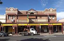
 Main Street of Laidley, 2011 | |||||||||||||||
 Laidley | |||||||||||||||
| Coordinates | 27.6313°S 152.3938°E | ||||||||||||||
| Population | 3,808 (2016 census)[1] | ||||||||||||||
| • Density | 213.9/km2 (554.1/sq mi) | ||||||||||||||
| Established | 1858 | ||||||||||||||
| Postcode(s) | 4341 | ||||||||||||||
| Area | 17.8 km2 (6.9 sq mi) | ||||||||||||||
| Time zone | AEST (UTC+10:00) | ||||||||||||||
| Location | |||||||||||||||
| LGA(s) | Lockyer Valley Region | ||||||||||||||
| County | Churchill | ||||||||||||||
| Parish | Laidley | ||||||||||||||
| State electorate(s) | Lockyer | ||||||||||||||
| Federal Division(s) | Wright | ||||||||||||||
| |||||||||||||||
Geography
Laidley is within the Lockyer Valley of South East Queensland and lies 83 kilometres (52 mi) west of Brisbane, the state capital.
The local industry has been dominated by agriculture since the end of the 19th century. Laidley has long regarded itself as "Queensland's Country Garden".[4] Fruit and vegetable production features prominently, with the majority of beetroot grown in Australia coming from the Laidley district.
History
Allan Cunningham first explored the area in 1829. Cunningham named it Laidley's Plain on 22 June 1829, after James Laidley, the Deputy Commissary General of the colony of New South Wales.[2][5]
The town developed around a wagon stop on the main road route between Ipswich and Toowoomba. A stop was needed after the climb over the small Little Liverpool Range west of Marburg.[5]
By the 1850s the area was being cleared for sheep grazing.[5] A survey for the growing village was conducted in 1858.[6]
Laidley Post Office opened on 1 February 1861.[7] Laidley Creek West Post Office was open from 1927 until 1955 (a receiving office had been open from 1899). Laidley Rail Post Office opened in 1915 and closed in 1925.[7]
The first Presbyterian service were held in Laidley in 1864 by William Lambie Nelson.[8]
In the mid-1870s the railway line from Grandchester stopped at a railway station 1.5 kilometres (0.93 mi) north of the town.[5] Between 1911 and 1955, a branch railway line ran from Laidley along the Laidley Creek to the settlement at Mulgowie.[9]
The town was the centre of the Shire of Laidley until 2008, when the shire was amalgamated into the new Lockyer Valley Region local government area.
In 2011 census, the township had a population of 3,518 people.[10]
The Laidley Library opened in 2017.[11]
Laidley Old Township Provisional School opened on 9 March 1908. On 1 January 1909 it became Laidley Central State School. The school closed on 12 December 1998 when it was replaced by Laidley District State School at a new location.[12][13][14]
St Mary's Catholic Primary School opened on 14 July 1912 by the Sisters of Mercy. The Sisters operated the school until 1988 when the first lay principal was appointed.[12]
Laidley State High School opened on 29 January 1985; this effectively replaced the secondary department that operated at Laidley North State School from 1864 to 1984.[12][13][15]
Heritage listings
Laidley has a number of heritage-listed sites, including:
- Toowoomba-Ipswich Road: Corduroy Road Remains[16]
- 91 Patrick Street: Whitehouse's Bakery[17]
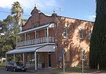
- 134 - 138 Patrick Street: Exchange Hotel[6]
- 140 - 142 Patrick Street: G Wyman Building[18]
Sport and recreation
The Laidley Golf Club is a public twelve hole course adjacent to Lake Dyer, two kilometres from the township of Laidley on Wehlow Road off Gatton-Laidley Road.[19] Established in 1951 at its present site, the original nine holes were designed by Ross Watson. A further three holes were designed by David Burrup in 2003. The competition course has thirteen different tees for the eighteen holes while the Social Course has fifteen different tees for the eighteen holes.[19] The "Laidley Classic" is held each year on the second week-end in April. The Classic commenced in 2011 with a Men's Event, it expanded to include a Ladies Event in 2012. In 2013 it was again expanded to a 2-day event for Men on Saturday and Sunday with a 1-day event for Ladies on Friday.
Education
Laidley District State School is a government primary (Early Childhood-6) school for boys and girls at 232 Patrick Street (27.6236°S 152.3953°E).[20][21] In 2017, the school had an enrolment of 375 students with 27 teachers and 20 non-teaching staff (14 full-time equivalent).[22] It includes a special education program.[20][23]
Laidley State High School is a government secondary (7-12) school for boys and girls at 98 Alfred Street (27.6362°S 152.4044°E).[20][24] In 2017, the school had an enrolment of 694 students with 65 teachers (63 full-time equivalent) and 33 non-teaching staff (23 full-time equivalent).[22] It includes a special education program.[20][23]
St Mary's School is a Catholic primary (Prep-6) school for boys and girls at John Street (27.6341°S 152.3916°E).[20][25] In 2017, the school had an enrolment of 267 students with 23 teachers (20 full-time equivalent) and 15 non-teaching staff (10 full-time equivalent).[22]
Amenities
The Lockyer Valley Regional Council operate a public library in Spicer Street.[26]
See also
References
- Australian Bureau of Statistics (27 June 2017). "Laidley (SSC)". 2016 Census QuickStats. Retrieved 20 October 2018.

- "Laidley - town in Lockyer Valley Region (entry 18796)". Queensland Place Names. Queensland Government. Retrieved 16 November 2019.
- "Laidley - locality in Lockyer Valley Region (entry 50039)". Queensland Place Names. Queensland Government. Retrieved 16 November 2019.
- Penguin Books Australia (2002). Explore Queensland. Camberwell, Victoria: Penguin Books Australia. p. 45. ISBN 0-14-300015-2.
- Queensland Environmental Protection Agency (2000). Heritage Trails of the Great South East. State of Queensland. p. 65. ISBN 0-7345-1008-X.
- "Exchange Hotel (entry 600653)". Queensland Heritage Register. Queensland Heritage Council. Retrieved 4 December 2014.
- Premier Postal History. "Post Office List". Premier Postal Auctions. Retrieved 10 May 2014.
- "Presbyterian Churches On The Downs - Downs Folk". Downs Folk. Archived from the original on 24 May 2020. Retrieved 24 May 2020.
- The Laidley Creek Branch Line Armstrong, J. Australian Railway Historical Society Bulletin April 1968 pp 91-95
- Australian Bureau of Statistics (31 October 2012). "Laidley (State Suburb)". 2011 Census QuickStats. Retrieved 4 December 2014.
- "Public Libraries Statistical Bulletin 2016-17" (PDF). Public Libraries Connect. State Library of Queensland. November 2017. p. 14. Archived (PDF) from the original on 30 January 2018. Retrieved 30 January 2018.
- Queensland Family History Society (2010), Queensland schools past and present (Version 1.01 ed.), Queensland Family History Society, ISBN 978-1-921171-26-0
- "Opening and closing dates of Queensland Schools". Queensland Government. Retrieved 18 April 2019.
- "Laidley District State School". Archived from the original on 4 February 2017. Retrieved 1 February 2017.
- "Laidley SHS". Archived from the original on 4 February 2017. Retrieved 1 February 2017.
- "Corduroy Road Remains, Laidley (entry 600657)". Queensland Heritage Register. Queensland Heritage Council. Retrieved 10 July 2013.
- "Whitehouse's Bakery (former), Laidley (entry 600656)". Queensland Heritage Register. Queensland Heritage Council. Retrieved 10 July 2013.
- "G Wyman Building (entry 600654)". Queensland Heritage Register. Queensland Heritage Council. Retrieved 10 July 2013.
- "Laidley Golf Club". Archived from the original on 26 October 2014. Retrieved 6 November 2014.
- "State and non-state school details". Queensland Government. 9 July 2018. Archived from the original on 21 November 2018. Retrieved 21 November 2018.
- "Laidley District State School". Archived from the original on 21 June 2012. Retrieved 21 November 2018.
- "ACARA School Profile 2017". Archived from the original on 22 November 2018. Retrieved 22 November 2018.
- "Laidley District SS - Special Education Program". Archived from the original on 21 June 2012. Retrieved 21 November 2018.
- "Laidley State High School". Archived from the original on 26 March 2012. Retrieved 21 November 2018.
- "St Mary's School". Archived from the original on 11 April 2013. Retrieved 21 November 2018.
- "Laidley Library". Lockyer Valley Regional Council. Archived from the original on 31 January 2018. Retrieved 31 January 2018.
External links
| Wikimedia Commons has media related to Laidley, Queensland. |
- "Laidley". Queensland Places. Centre for the Government of Queensland, University of Queensland.
- Town map of Laidley, 1978, sheet 1
- map of Laidley, 1978, sheet 2
- Laidley Golf Club