L'Assomption, Quebec
L'Assomption is an off-island suburb of Montreal, in southwestern Quebec, Canada on the L'Assomption River. It is the seat of the Regional County Municipality of L'Assomption. It is located on the outer fringes of the Montreal urban area.
L'Assomption | |
|---|---|
City | |
 | |
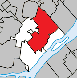 Location within L'Assomption RCM | |
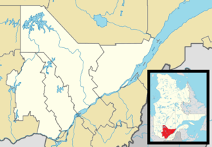 L'Assomption Location in central Quebec | |
| Coordinates: 45°50′N 73°25′W[1] | |
| Country | |
| Province | |
| Region | Lanaudière |
| RCM | L'Assomption |
| Settled | 1670s |
| Constituted | July 1, 2000 |
| Government | |
| • Mayor | Sébastien Nadeau |
| • Federal riding | Repentigny |
| • Prov. riding | L'Assomption |
| Area | |
| • Total | 100.80 km2 (38.92 sq mi) |
| • Land | 98.90 km2 (38.19 sq mi) |
| Population (2011)[3] | |
| • Total | 20,065 |
| • Density | 202.9/km2 (526/sq mi) |
| • Pop 2006–2011 | |
| • Dwellings | 8,189 |
| Time zone | UTC−5 (EST) |
| • Summer (DST) | UTC−4 (EDT) |
| Postal code(s) | J5W |
| Area code(s) | 450 and 579 |
| Highways | |
| Website | www |
Most of the economy depends on the agricultural industries of the surrounding plains. It is also the cultural centre of the region.
History
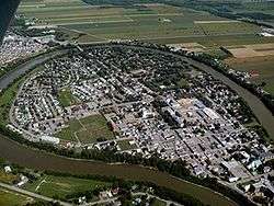
In 1647, the L'Assomption Seignory was granted to Pierre Legardeur de Repentigny, named after the river already named such since the seventeenth century. Between 1640 and 1700, a settlement formed inside a large horseshoe-shaped meander of the L'Assomption River. Amerindians had already been visiting this site since ancient times and called it Outaragasipi meaning widening river, in reference to the river's course. They would drag their canoes across the peninsula as a short-cut for the meander, and therefore the settlement was first called Le Portage.[1]
In 1717, the parish was formed, known thereafter as Saint-Pierre-du-Portage-de-l'Assomption and also as Saint-Pierre-et-Saint-Paul-du-Portage. In 1766, the village saw an influx of Acadian settlers. Between 1774 and 1888, L'Assomption was the most prosperous and important town between Montreal and Trois-Rivieres.[1]
In 1845, the L'Assomption Municipality was established, abolished in 1847, but reestablished as a parish municipality in 1855. In 1846, the village itself became a separate Village Municipality and obtained town status in 1888.[1]
In 1992, the town and parish municipality were merged again, and on July 1, 2000, the neighbouring Parish Municipality of Saint-Gérard-Majella was amalgamated with Ville de L'Assomption.[1]
In December 2010, the 1,300-worker Electrolux factory announced that it would close, relocating to Memphis, Tennessee.[4]
Demographics
Population
| Canada census – L'Assomption, Quebec community profile | |||
|---|---|---|---|
| 2011 | 2006 | ||
| Population: | 20,065 (+20.0% from 2006) | 16,738 (+7.1% from 2001) | |
| Land area: | 98.90 km2 (38.19 sq mi) | 100.78 km2 (38.91 sq mi) | |
| Population density: | 202.9/km2 (526/sq mi) | 166.1/km2 (430/sq mi) | |
| Median age: | 37.9 (M: 37.2, F: 38.7) | 39.3 (M: 38.7, F: 39.7) | |
| Total private dwellings: | 8,189 | 6,526 | |
| Median household income: | $61,590 | $58,130 | |
| References: 2011[3] 2006[5] earlier[6] | |||
| Historical Census Data – L'Assomption, Quebec[7] | |||||||||||||||||||||||||||||||||||
|---|---|---|---|---|---|---|---|---|---|---|---|---|---|---|---|---|---|---|---|---|---|---|---|---|---|---|---|---|---|---|---|---|---|---|---|
|
|
| |||||||||||||||||||||||||||||||||
(A) adjusted figures due to boundary changes | |||||||||||||||||||||||||||||||||||
Language
| Canada Census Mother Tongue – L'Assomption, Quebec[7] | ||||||||||||||||||
|---|---|---|---|---|---|---|---|---|---|---|---|---|---|---|---|---|---|---|
| Census | Total | French |
English |
French & English |
Other | |||||||||||||
| Year | Responses | Count | Trend | Pop % | Count | Trend | Pop % | Count | Trend | Pop % | Count | Trend | Pop % | |||||
2011 |
19,815 |
19,165 | 96.72% | 195 | 0.98% | 100 | 0.50% | 355 | 1.79% | |||||||||
2006 |
16,545 |
16,110 | 97.37% | 200 | 1.21% | 35 | 0.21% | 200 | 1.21% | |||||||||
2001 |
15,340 |
14,980 | 97.65% | 185 | 1.21% | 45 | 0.29% | 130 | 0.85% | |||||||||
1996 |
11,035 |
10,870 | n/a | 98.51% | 80 | n/a | 0.72% | 35 | n/a | 0.32% | 50 | n/a | 0.45% | |||||
Communities
- Domaine-Beaudoin-Papin
- Domaine-des-Fleurs
- L'Assomption
- Saint-Gérard-Majella
Education
The Sir Wilfrid Laurier School Board operates anglophone public schools, including:
- Joliette Elementary School in Saint-Charles-Borromée[8]
See also
- List of cities in Quebec
References
- "L'Assomption (Ville)" (in French). Commission de toponymie du Québec. Retrieved 2009-09-22.
- Geographic code 60028 in the official Répertoire des municipalités (in French)
- "2011 Community Profiles". 2011 Canadian Census. Statistics Canada. July 5, 2013. Retrieved 2014-05-26.
- http://www.commercialappeal.com/news/2011/sep/18/straberg-strategy-cutting-costs-electrolux-memphis/
- "2006 Community Profiles". 2006 Canadian Census. Statistics Canada. March 30, 2011. Retrieved 2014-05-26.
- "2001 Community Profiles". 2001 Canadian Census. Statistics Canada. February 17, 2012.
- Statistics Canada: 1996, 2001, 2006, 2011 census
- "JOLIETTE ELEMENTARY ZONE." Sir Wilfrid Laurier School Board. Retrieved on September 17, 2017.
Adjacent Municipal Subdivisions | ||||||||||
|---|---|---|---|---|---|---|---|---|---|---|
| ||||||||||
| Cities/towns | |
|---|---|
| Municipalities | |
| |
| Authority control |
|
|---|