Kushalanagar
Kushalanagar is a city located in the Kodagu district of Karnataka state of India.Kushalnagar is one of the rapidly developing city in the state and it acts as Gateway of Kodagu. Kushalnagar was considered as the newest taluk named Cauvery taluk of the district along with Ponnampete, but the plan is yet to be done.
Kushalanagar | |
|---|---|
City | |
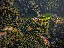 Aerial view of Coorg near Kushalnagar | |
 Kushalanagar Location in Karnataka, India  Kushalanagar Kushalanagar (India) | |
| Coordinates: 12.467°N 75.967°E | |
| Country | |
| State | Karnataka |
| District | Kodagu (Coorg) |
| Government | |
| • Body | Town Panchayat |
| Area | |
| • Total | 10 km2 (4 sq mi) |
| Elevation | 844 m (2,769 ft) |
| • Density | 3,296.5/km2 (8,538/sq mi) |
| Languages | |
| • Official | Kannada |
| Time zone | UTC+5:30 (IST) |
| PIN | 571 234 |
| Telephone code | 08276 |
| ISO 3166 code | IN-KA |
| Vehicle registration | KA-12 |
Etymology
According to popular myth, the name was given by Hyder Ali who was camped there when he received news of the birth of his son Tipu and called it as Kushyal nagar (="town of gladness")[1] But in reality, Tipu was born around 1750 while Hyder Ali entered Kodagu for the first time in the 1760s. After the British conquest of Coorg it was known as Fraserpet after Colonel James Stuart Fraser who was the Political Agent in Coorg around 1834.[2]
Geography
Kushalanagar is located at 12.47°N 75.97°E.[3] It has an average elevation of 844 metres (2726 feet).[4]
Kushalnagar prior to announce as Taluk, used to be part of Somwarpet Taluk. Being not have too much of hills, Kushalnagar has become Business centre for North Kodagu.
Demographics
As of 2011 India census,[5] Kushalanagara had a population of 26,487. Males constitute 53% of the population and females 47%. Kushalanagar has an average literacy rate of 78%, higher than the national average of 59.5%: male literacy is 82%, and female literacy is 73%. 12% of the population is under 6 years of age.
There are natively 2 category of people present who are still dominating in population in these areas, Kodagu Gowdas (aka Are Bashe Gowdas) and Kodavas (aka Coorgees)
Education
Kushalanagar has an average literacy rate of 78%. People are Found to given more preference to education every year.
It has total of 6 Private Schools, and 1 Government School (From Kindergarten to degree). Which have attracted neighbour villages to move to the Kushalnagar Town. The SAINIK SCHOOL is situated in the outrange of the city where the students are studied and trained to serve our national army.
Tourism
Kodagu has plenty of Tourist spots, the beauty of western ghats and its thick mist and cool temperature has made it as a most preferred place to visit in Karnataka. Kushalnagar has a very good transportation services from Bengaluru and Mysore, which made it gateway for tourists to enter Kodagu (another entry point is via Gonikoppa) also this is the only place one can get self driven cars in coorg. There are no railway service anywhere in Kodagu, However train project to Kushalnagar is in controversy from long time.
Kushalnagar itself has following tourists spots
- Kaveri Nisargadhama
- Golden Temple
- Harangi Backwaters
- Harangi Reservoir
- Dubare
- Chiklihole
- Aiyappa Swamy Temple
- Kanive
Transportation
Kushalnagar is well with transportation facilities. It has one government bus station where the services are provided to all the Intrastate and Interstate regions.Airports Authority of India has proposed a construction of new mini airport named Kushalnagar airport in the city, which will boost the tourism from other parts of the state. The nearest airport is at Mysore and the nearest international airport is Kannur international airport.
See also
References
- Anonymous (1855). A gazetteer of Southern India. Madras: Pharoah and Co. p. 580.
- Anon. 1908 The Imperial Gazetteer of India. Vol. 11. Oxford. page 12
- "Maps, Weather, and Airports for Kushalnagar, India". www.fallingrain.com.
- "Elevation of Kushalnagar". Archived from the original on 21 May 2019. Retrieved 15 October 2017.
- "Census of India 2001: Data from the 2001 Census, including cities, villages and towns (Provisional)". Census Commission of India. Archived from the original on 16 June 2004. Retrieved 1 November 2008.
| Wikimedia Commons has media related to Kushalanagar. |