Kuningan Regency
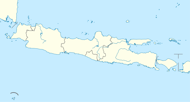
Kuningan Regency is a regency (kabupaten) of West Java province, Indonesia. It covers an area of 1,110.56 km2, and had a population of 1,035,589 at the 2010 Census; the latest official estimate (as at 2015) is 1,055,417. The town and district of Kuningan is its administrative capital. Kuningan Regency is located in the east of the province, south of Cirebon Regency and bordering Central Java Province to the east.
Kuningan Regency Kabupaten Kuningan | |
|---|---|
Regency | |
| Other transcription(s) | |
| • Sundanese | ᮊᮘᮥᮕᮒᮦᮔ᮪ ᮊᮥᮔᮤᮍᮔ᮪ |
Seal | |
| Motto(s): Aman Sehat Rindang Indah (Safe, Healthful, Shady, Beautiful) | |
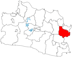 Location within West Java | |
| Coordinates: 6°58′34″S 108°29′04″E | |
| Country | Indonesia |
| Province | West Java |
| Established | September 1, 1948 |
| Government | |
| • Regent | Acep Purnama |
| • Vice Regent | Dede Sembada |
| Area | |
| • Total | 1,110.56 km2 (428.79 sq mi) |
| Elevation | 680 m (2,520 ft) |
| Population (2015) | |
| • Total | 1,055,417 |
| Time zone | UTC+7 (Indonesia Western Time) |
| Area code(s) | +62 232 |
| Website | kuningankab.go.id |

Etymology
The area of eastern slopes and valley of Mount Cereme has been known as the Kuningan Duchy since the Hindu period as part of the Galuh Kingdom circa 14th century. The name Kuningan is believed to have come from the Sundanese word kuning meaning "yellow". Alternate theory suggests the name proliferated from the Sundanese word kuningan, a local name for brass, the metal which have been produced and used for hundreds of years in this area. While according to the local tradition, the name Kuningan derived from the Prince Arya Kuningan or Adipati Kemuning, a local hero and ruler of this region circa 1498.
History
Prehistoric era
The oldest archaeological findings in the region were found in 1972, objects such as sherds, stone tools, gravestones and ceramics were unearthed in the Cipari megalithic site with evidences from the bronze and iron metallurgical culture, assumes it belonged to the Old Megalithicum age, from around 3500 BC to 1500 BC.[1]
Hindu-Buddhist period
The area around Kuningan was originally under the control of Tarumanagara Kingdom. After the split of Galuh and Sunda kingdom, Galuh came into ruling the region, the reference to which were found in the story of Parahyangan (Carita Parahyangan).
Islamic period
In 15th century, an ulama and also a ruler named Syarif Hidayatullah settled in Cirebon, with the intention of spreading Islam in this still pagan area. In the meantime, his pregnant wife Queen Ong-thien Nio from Ming China came to Kuningan and gave birth to a child named Prince of Kuningan. Prince of Kuningan establish his own realm and ascend the throne on September 1, 1498, a date regarded as the official establishment of Kuningan Regency.
Post-Independence period
A notable event in Indonesian history occurred in Kuningan when the Linggadjati Agreement was signed between the Indonesian and Dutch government on November 15, 1946, in the village of Linggajati within the regency. There is a dedicated small museum at the village, about 25 km from Cirebon, which records the events of the Linggadjati conference.
Geography
Kuningan is bordered by Cirebon to the north, Majalengka to the west, Ciamis to the south and Brebes, Central Java to the east. The regency capital is the Kuningan District. Its mean elevation is 680 metres (2,520 ft) above sea level. The regency's landscape is composed of volcanoes, steep terrain, forest, mountains rivers and fertile agricultural land. The highest mountain in the province, Ciremai (3,076 m) is located between the border this regency and Majalengka Regency. There are numerous tropical rainforests in Kuningan, which contain tree species such as Pinus (Pinus merkusii), Teureup (Artocarpus elasticus), Yellow mahogany (Dysoxylum caulostachyum), Langsat (Lansium domesticum), and Putat (Planchonia valida).
Demographics
Population
According to the 2010 Census, Kuningan's population is 1,035,589 people, consists of 520,632 male and 514,957 female. The population is 97% Muslim, 2% Catholics and 1% follower of other religions. Its ethnic composition consists of Sundanese 95%, Javanese 2%, and other groups 3%. In addition to Indonesian, the official national language, the other widely spoken language in the regency is Sundanese. In some areas near the eastern border with Central Java, Javanese and Banyumasan is also spoken.
Economy
Small scale enterprise in the regency includes the production of patchouli oil, an essential oil produced from Patchouli. But the cost and quality of patchouli oil produced in the area still needs to be improved.[2] The selling price of patchouli in the region fluctuates markedly. This reflects several factors including market access to end users and the role of national brokers in the marketing chain. Standards of processing and refining of raw materials are not of high standards. Distillation is done at the local level and quality is still low (not meeting ISO levels). Amongst other things, this is because farmers who are producing local patchouli oil do not pay attention to factors such as the treatment of raw materials, the proportion of patchouli stems used with leaves, distillation methods, types of material used, reliance on solar stills, and inappropriate cooling and circulation techniques in production.
Quality improvement efforts that need to be adopted include improving the quality of the Fe (iron) content of patchouli oil because excessive levels make the oil too dark. Purification can reduce levels of iron from as high as 340.2 ppm down to 104.5 ppm. Further, densities that too small or too large reduce the low percentage of essential oil which can recovered.
Identification of the main components of local patchouli oil indicates a value of patchouli alcohol (PA) of about 27-29%. Improved treatment of material to be distilled can raise levels of PA to about 30-32%.
Administrative divisions
The Kuningan Regency has an area of 1,110.56 km²; with an average population density of 1,003 people per km² in 2014. It is divided into 32 districts (kecamatan), subdivided in turn into 376 village (desa/kelurahan). These are listed below with their areas and their populations at the 2010 Census.[3]
|
|
Tourism
Tourist destinations
There are several tourist locations in Kuningan Regency such as: the Linggarjati Museum, Sangkanhurip Hot Springs, Cibulan and Cigugur fish pond, Darma Dam (Waduk Darma), Cipari's Ancient settlement, and Talaga Remis (Remis Lake).
The area of Palutungan, a new location tourist destination is known as the "Lembang of Kuningan" (Lembang is famous tourist destination near Bandung) is located in 1,100 meter above sea level which has fresh air, good views and an 8-meter waterfall. The waterfall is called Curug Putri (Lady Waterfall) is located in Cisantana village, Cigugur subdistrict. The travel from Kuningan to Palutungan can pass through Cigugur fish pond and Cisantana Maria retreat cave.[4]
Kuningan Botanical Garden
Kuningan Botanical Garden in Padabeunghar Village is 154.9 hectares and in September 2012, 29 hectares is on fire which killed 10,014 trees of 30 species. All of burn trees are not yet catalogued because of its pioneer status which are planted in 2007.[5]
Sports
Kuningan is the home town of the Pesik football team. Its home base is Mashud Wisnusaputra Stadium. Other potential sports in Kuningan is athletics.
References
- "Cipari - Ancient Village or Settlement in Indonesia". The Megalithic Portal.
- Patchouli oil is also produced in other areas of Indonesia, such as in Bali and East Java. See Duncan Graham 'Essential improvements for essential oil', The Jakarta Post, 29 May 2006.
- Biro Pusat Statistik, Jakarta, 2011.
- 'Lembang of Kuningan'
- "Lebih Dari Sepuluh Ribu Pohon Pionir di Kebun Raya Kuningan Mati Terbakar". September 9, 2012.