Korendijk
Korendijk listen ![]()
Korendijk | |
|---|---|
Former municipality | |
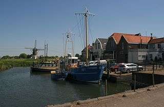 Harbour of Nieuw-Beijerland | |
 Flag  Coat of arms | |
.svg.png) Location in South Holland | |
| Coordinates: 51°48′N 4°19′E | |
| Country | Netherlands |
| Province | South Holland |
| Established | 1 January 1984 |
| Government | |
| • Body | Municipal council |
| • Mayor | Servaas Stoop (acting) (SGP) |
| Area | |
| • Total | 100.47 km2 (38.79 sq mi) |
| • Land | 77.26 km2 (29.83 sq mi) |
| • Water | 23.21 km2 (8.96 sq mi) |
| Elevation | 0 m (0 ft) |
| Time zone | UTC+1 (CET) |
| • Summer (DST) | UTC+2 (CEST) |
| Postcode | 3264–3267, 3284 |
| Area code | 0186 |
| Website | www |
With the municipal reorganization of the Hoeksche Waard on 1 January 1984, the municipality of Korendijk was formed out of the former municipalities of Goudswaard, Nieuw-Beijerland, Piershil (location of town hall), Zuid-Beijerland, and the island Tiengemeten. In addition to these villages, it also had the population centres Nieuwendijk and Zuidzijde. On 1 January 2019, it merged into the municipality of Hoeksche Waard.[4]
The municipality of Korendijk was bordered on the southside by the Haringvliet estuary, on the westside by the Spui River, and by the municipalities Oud-Beijerland and Cromstrijen to the north and east.
Topography

Dutch Topographic map of the municipality of Korendijk, June 2015
See also
References
- "College van B&W" [Board of mayor and aldermen] (in Dutch). Gemeente Korendijk. Archived from the original on 10 November 2013. Retrieved 1 August 2013.
- "Kerncijfers wijken en buurten" [Key figures for neighbourhoods]. CBS Statline (in Dutch). CBS. 2 July 2013. Retrieved 12 March 2014.
- "Postcodetool for 3265BT". Actueel Hoogtebestand Nederland (in Dutch). Het Waterschapshuis. Archived from the original on 21 September 2013. Retrieved 1 August 2013.
- "Gemeentelijke indeling op 1 januari 2019". CBS (in Dutch). Retrieved 22 December 2019.
External links
Places adjacent to Korendijk | |
|---|---|