Spijkenisse
Spijkenisse (Dutch pronunciation: [spɛi̯kəˈnɪsə] (![]()
Spijkenisse | |
|---|---|
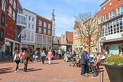 City centre of Spijkenisse | |
 Flag  Coat of arms | |
.svg.png) Location in South Holland | |
| Coordinates: 51°51′N 4°20′E | |
| Country | Netherlands |
| Province | South Holland |
| Municipality | Nissewaard |
| Area | |
| • Total | 30.27 km2 (11.69 sq mi) |
| • Land | 26.12 km2 (10.08 sq mi) |
| • Water | 4.15 km2 (1.60 sq mi) |
| Elevation | −1 m (−3 ft) |
| Population | |
| • Total | 72,500 |
| Demonym(s) | Spijkenissenaar |
| Time zone | UTC+1 (CET) |
| • Summer (DST) | UTC+2 (CEST) |
| Postcode | 3200–3209 |
| Area code | 0181 |
| Website | www |
History

Archaeological research has shown that the area around Spijkenisse has been inhabited for many thousands of years. The people then depended on fishing on the Meuse and hunting in the swamps.
The oldest reference to the name Spickenisse is from a source from 1231. This name comes from the words spieke (spit) and nesse (nose) meaning "pointy nose" in reference to a spit of land protruding along the river.[3]
Spijkenisse formed as a farming and fishing village at a creek along the Oude Maas. Initially it belonged to the Lord of Putten (whose coat of arms is now used by the city) but in 1459 the fiefdom Putten, including Spijkenisse, was transferred to Philip III, Duke of Burgundy. In 1581, after the Dutch declaration of independence, the area came under the control of the States of Holland and West Frisia.[4]
In the 16th century the village suffered several floods. In the 17th and 18th centuries it endured destructive fires which hampered its economic growth. In the 20th century, it heavily urbanised as part of the Greater Rotterdam area. Nowadays, Spijkenisse also includes the community of Hekelingen, as well as Den Hoek and Beerenplaat.
Public transportation
Spijkenisse has a connection to the city of Rotterdam by Rotterdam Metro lines C and D, through Spijkenisse Centrum, Heemraadlaan, and De Akkers stations. The metro is operated by RET.
There are also several bus services operated by EBS and 1 line of Connexxion to Ouddorp.
Districts
- De Akkers
- Centrum
- De Elementen
- De Hoek
- Gildenwijk
- Groenewoud
- Hoogwerf
- Maaswijk
- Schenkel
- Schiekamp
- Sterrenkwartier
- Vierambachten
- Vogelenzang
- Vriesland
- Waterland
Health
- Spijkenisse Medisch Centrum (former Ruwaard van Putten hospital)
Schools
Primary schools
| Roman Catholic | Protestant | Public | Calvinist |
|---|---|---|---|
| De Akkers | Het Anker | Annie MG Schmidt | De Morgenster |
| De Klinker | Het Baken | De Vuurvogel | |
| De Maasoever | De Bron | ||
| Monseigneur Bekkersschool | De Duif | De Vogelenzang | |
| De Wegwijzer | De Hoeksteen | De Krullevaar | |
| Paus Johannes | De Marimba | De Meander(tot 2012) | |
| De Rank | De Montessori | ||
| De Schakel | Jan Campert | ||
| De Piramide | |||
| De Toermalijn | |||
| De Veenvlinder |
Secondary school
| Roman Catholic | Christian | Public |
|---|---|---|
| Wereld MAVO Charles de Foucauld | PENTA college CSG Scala Molenwatering | OSG My College |
| PENTA College CSG Scala Rietvelden | OSG De Ring van Putten | |
| PENTA college CSG De Oude Maas |
Notable residents
- Jan Campert (1902 in Spijkenisse – 1943) a journalist, theater critic and writer
- Marleen de Pater-van der Meer (1950 in Hekelingen – 2015) a Dutch politician
- Jan Bechtum (born 1958 in Spijkenisse) a Dutch guitarist and composer
- Erik de Jong (born 1961 in Spijkenisse) known as Spinvis, a Dutch one-man music project
- Medy van der Laan (born 1968 in Spijkenisse) a retired Dutch politician
- Sied van Riel (born 1978) a Dutch trance music DJ and producer, lives in Spijkenisse
- Björn Franken (born 1983 in Spijkenisse) known as Vato Gonzalez, DJ and producer
- Nick van de Wall (born 1987 in Spijkenisse) known as Afrojack, DJ and producer
- Duncan Laurence (born 1994 in Spijkenisse) singer, winner of the Eurovision Song Contest 2019
- Sport
- Bram Groeneweg (1905 in Spijkenisse – 1988) a Dutch long-distance runner, competed in the marathon at the 1928 Summer Olympics
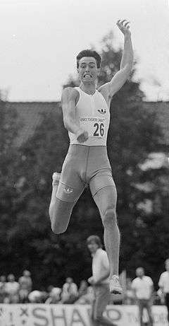
- Emiel Mellaard (born 1966 in Spijkenisse) is a retired Dutch long jump record holder
- Joeri de Groot (born 1977 in Spijkenisse) a Dutch rower, competed at the 2004 Summer Olympics
- Patrick van Luijk (born 1984 in Spijkenisse) a Dutch sprinter
- Martijn Barto (born 1984 in Spijkenisse) a Dutch professional footballer with over 200 club caps
International relations
Spijkenisse is twinned with the following cities:
|
Gallery
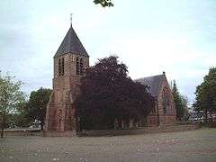 The medieval village church is the oldest building in Spijkenisse.
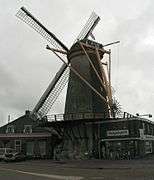 Windmill "Nooitgedacht" in Spijkenisse.
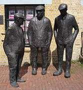 Mannetjes op de krom by Bert Kiewiet
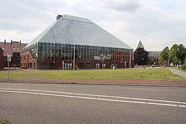 The library "Bookmountain"
 The Rokade
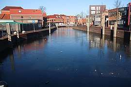 Ice in the harbour of spijkenisse
 The Maasboulevard
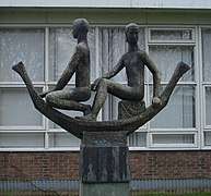 Sculpture "droomboot" (dream boat)
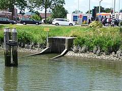 Outfall sluice
References
- "Kerncijfers wijken en buurten" [Key figures for neighbourhoods]. CBS Statline (in Dutch). CBS. 2 July 2013. Retrieved 12 March 2014.
- "Postcodetool for 3201EL". Actueel Hoogtebestand Nederland (in Dutch). Het Waterschapshuis. Retrieved 24 August 2013.
- "Gemeente Spijkenisse". Spijkenisse.nl. Retrieved 2014-02-10.
- Spijkenisse Online - geschiedenis Archived June 7, 2011, at the Wayback Machine
External links
| Wikimedia Commons has media related to Spijkenisse. |
| Wikivoyage has a travel guide for Spijkenisse. |
Places adjacent to Spijkenisse | ||||||||||
|---|---|---|---|---|---|---|---|---|---|---|
| ||||||||||