Lake Kopa
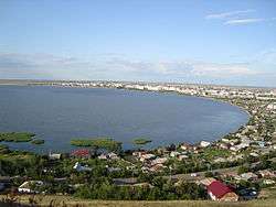
Kopa Lake (Kazakh: Қопа, Qopa) is a lake in the town of Kokshetau, located in the Akmola Region of Kazakhstan.
| Lake Kopa | |
|---|---|
 Kopa, lake | |
 Lake Kopa | |
| Location | Akmola Region, Kazakhstan |
| Coordinates | 53°18′34″N 69°20′36″E |
| Type | lake |
| Native name | Қопа (Kazakh) |
The lake is the main water source for Kokshetau.[1]
History
The area where the lake now stands was once swampland. In the late 1800s Military authorities ordered a canal be dug from the Chaglinka River such that the redirected waters turned the swamp into the Lake Kopa.[2]
In 1974 work began to clean sediment from Lake Kopa, which continued intermittently until 1993. In total, approximately 400,000 cubic metres (14,000,000 cu ft) of sand and gravel were removed from the lake.
Location and description
Located near the foot of the Kokchetav Massif, and near the north-western part of the city of Kokshetau, the lake has an area of 14 square kilometres (5.4 sq mi) and an average depth of 2.0–3.0 metres (6 ft 7 in–9 ft 10 in). Most of the total catchment area of 3,860 square kilometres (1,490 sq mi), is accounted for by the tributaries of the lake: the Chaglinka river to the southwest, and the Kylshakty river to southeast. Only a very small part, 80 square kilometres (31 sq mi), comes from the lake itself.
The south and west sides of the lake are separated from the adjacent beaches by depressed areas, and along the southern and eastern coasts are sand and pebble beaches. The northern and eastern shores of the lake are low, flat, and overgrown with vegetation, meaning that the water surface of the lake is basically open only along the western and northern stretches. The lake bottom is viscous, smooth, and covered with a layer of silt clay, loam, and sand, it averages 2 metres (6 ft 7 in), but can reach a depth of as much as 6 metres (20 ft) in the northern part.
In 1955, the volume of water in the lake was 39,200,000 cubic metres (1.38×10⁹ cu ft), with a surface area of 13.6 square kilometres (5.3 sq mi). From 1955 to 1990 the volume of the lake has decreased by 13,000,000 cubic metres (460,000,000 cu ft) and now stands at only 26,000,000 cubic metres (920,000,000 cu ft). The lake sees amplitude fluctuations of between 0.5 and 1.5 metres (1 ft 8 in and 4 ft 11 in).
The State of the lake
In recent years the water level of the lake has fallen, leading to increased salinity, and the resultant reduction in water quality has imperilled its use as a water supply.[3]
A five year restoration project budgeted at 4,950 million tenge was announced in 2009 by Anuarbek Sagitov, head of the department of nature management. Over twenty years of images of the lake taken by NASA would be analyzed to discover the morphology of the bottom of the lake.[4]
Previously populated with unionidae, lamelliformis and other molluscs, at the end of the 1970s pollution wiped out all edible molluscs.[5]
Currently, the government conducts routine laboratory tests of the water quality of Lake Copa. Laboratory monitoring is carried out at four control points on physical, chemical, and microbiological properties. According to the service Kazhydromet, the composition of the lake waters on the pollution index corresponds to "moderately polluted".
See also
Photos and videos
References
- Kazangapova, N; Kunshygar, D.Z.; Romanova, Sophia (1 January 2016). "The hydrochemical characteristic of lake Kopa". pp. 79–84.
- "Kokshetau – Magjan". magjan.kz (in Russian).
- Romanova, S.M.; Kazangapova, N.B. (2013). "Quality of Kazakhstan lakes water in contemporaneous period (for example of Kopa lake)". International Journal of Biology and Chemistry. Retrieved 31 May 2018.
- Baymuldin N. (2009-06-25). "Lake will жить" (newspaper) (359 (16745)). Archived from the original on 20 April 2014.
- "Последняя mystery Kokchetav озера". wp.itacom.kz. Archived from the original on 2012-05-17. Retrieved 2011-11-26.