Ko Sichang District
Ko Sichang (or Koh Sichang, Thai: เกาะสีชัง, pronounced [kɔ̀ʔ̚ sǐː.t͡ɕʰāŋ]) is a district (amphoe) of Chonburi Province, Thailand. It consists of the island of Ko Sichang and its adjoining islands. Ko Sichang is in the Gulf of Thailand, 12 km off the shore of Si Racha District.
Ko Sichang เกาะสีชัง | |
|---|---|
.jpg) | |
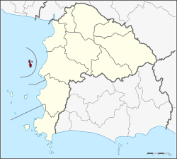 District location in Chonburi Province | |
| Coordinates: 13°09′48″N 100°48′30″E | |
| Country | Thailand |
| Province | Chonburi |
| Seat | Tha Thewawong |
| Area | |
| • Total | 17.3 km2 (6.7 sq mi) |
| Population (2005) | |
| • Total | 5,038 |
| • Density | 291/km2 (750/sq mi) |
| Time zone | UTC+7 (ICT) |
| Postal code | 20120 |
| Geocode | 2008 |
History
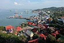
Three kings of the Chakri Dynasty, King Rama IV, Rama V, and Rama VI, occasionally visited the island for rest. King Rama V built a summer palace, Phra Chuthathut Palace (Thai: พระจุฑาธุชราชฐาน), named after his son who was born on this island, Prince Chuthathut. The royal residence was largely abandoned in 1893 after the French occupied the island during a conflict with Thailand over control of neighboring Laos. In 1900, parts of the palace was torn down and reassembled as part of Vimanmek Mansion in Bangkok.
The British diplomat John Crawfurd, visiting the islands in 1822 during his mission, described the island in his book Journal of an embassy from the Governor-General of India to the courts of Siam and Cochin-China: exhibiting a view of the actual state of those kingdoms. He reported that Francis Buchanan-Hamilton called the islands of Ko Sichang District the "Dutch Islands", and Ko Sichang itself "Amsterdam", due to frequent visits by ships of the Dutch East India Company during the 17th century.[1] American diplomat Edmund Roberts visited the island in the 1830s[2], describing the area as being occupied by "a few fisherman" who also grew yams, bananas, capsicums, gourds, and cucumbers.[2]
The island was originally a minor district (king amphoe) under the Mueang Samut Prakan District of Samut Prakan Province. On 1 January 1943, it was reassigned to the Si Racha District of Chonburi Province.[3] On 4 July 1994 the minor district was upgraded to a full district.[4]
Climate
Ko Sichang has a tropical savanna climate (Köppen climate classification Aw). Maximum temperatures remain fairly hot throughout the year, ranging from 29.6 °C (85.3 °F) in December to 32.9 °C (91.2 °F) in April. The monsoon season runs from May through October, with heavy rainfall.
| Climate data for Ko Sichang (1981–2010) | |||||||||||||
|---|---|---|---|---|---|---|---|---|---|---|---|---|---|
| Month | Jan | Feb | Mar | Apr | May | Jun | Jul | Aug | Sep | Oct | Nov | Dec | Year |
| Record high °C (°F) | 35.6 (96.1) |
35.2 (95.4) |
36.0 (96.8) |
36.6 (97.9) |
35.8 (96.4) |
34.7 (94.5) |
35.6 (96.1) |
34.8 (94.6) |
34.8 (94.6) |
34.5 (94.1) |
34.5 (94.1) |
34.6 (94.3) |
36.6 (97.9) |
| Average high °C (°F) | 30.3 (86.5) |
31.0 (87.8) |
31.9 (89.4) |
33.0 (91.4) |
32.5 (90.5) |
31.9 (89.4) |
31.5 (88.7) |
31.3 (88.3) |
30.9 (87.6) |
30.9 (87.6) |
30.6 (87.1) |
29.9 (85.8) |
31.3 (88.3) |
| Daily mean °C (°F) | 26.5 (79.7) |
27.6 (81.7) |
28.7 (83.7) |
29.8 (85.6) |
29.6 (85.3) |
29.3 (84.7) |
28.9 (84.0) |
28.7 (83.7) |
28.1 (82.6) |
27.5 (81.5) |
27.2 (81.0) |
26.2 (79.2) |
28.2 (82.8) |
| Average low °C (°F) | 22.6 (72.7) |
24.7 (76.5) |
26.0 (78.8) |
27.1 (80.8) |
26.9 (80.4) |
26.8 (80.2) |
26.1 (79.0) |
26.2 (79.2) |
25.1 (77.2) |
24.5 (76.1) |
24.0 (75.2) |
22.5 (72.5) |
25.2 (77.4) |
| Record low °C (°F) | 15.6 (60.1) |
17.0 (62.6) |
17.4 (63.3) |
22.0 (71.6) |
22.0 (71.6) |
21.0 (69.8) |
15.0 (59.0) |
20.0 (68.0) |
20.0 (68.0) |
19.1 (66.4) |
16.2 (61.2) |
14.8 (58.6) |
14.8 (58.6) |
| Average rainfall mm (inches) | 10.9 (0.43) |
15.7 (0.62) |
49.6 (1.95) |
77.3 (3.04) |
134.4 (5.29) |
125.4 (4.94) |
123.4 (4.86) |
136.8 (5.39) |
269.2 (10.60) |
207.1 (8.15) |
60.6 (2.39) |
8.5 (0.33) |
1,218.9 (47.99) |
| Average rainy days | 1.2 | 2.5 | 3.7 | 5.6 | 12.0 | 12.2 | 12.5 | 13.9 | 18.6 | 15.7 | 5.3 | 1.4 | 104.6 |
| Average relative humidity (%) | 73 | 76 | 76 | 76 | 77 | 76 | 77 | 78 | 81 | 82 | 74 | 68 | 76 |
| Mean monthly sunshine hours | 229.4 | 211.9 | 201.5 | 204.0 | 155.0 | 114.0 | 117.8 | 114.7 | 108.0 | 145.7 | 186.0 | 226.3 | 2,014.3 |
| Mean daily sunshine hours | 7.4 | 7.5 | 6.5 | 6.8 | 5.0 | 3.8 | 3.8 | 3.7 | 3.6 | 4.7 | 6.2 | 7.3 | 5.5 |
| Source 1: Thai Meteorological Department[5] | |||||||||||||
| Source 2: Office of Water Management and Hydrology, Royal Irrigation Department (sun and humidity)[6] | |||||||||||||
Administration
The district consists of a single sub-district (tambon) Tha Thewawong (ท่าเทววงษ์), which is further subdivided into seven villages (mubans). The district is completely covered by the township (thesaban tambon) Ko Sichang.
Nearby islands
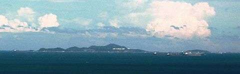
- Ko Sampan Yue
- Ko Kham Noi
- Ko Kham Yai
- Ko Prong
- Ko Ran Dok Mai
- Ko Yai Thao
- Ko Khangkhao
- Ko Thai Ta Muen
See also
References
- Crawfurd, John (1830). Journal of an embassy from the Governor-General of India to the courts of Siam and Cochin-China: exhibiting a view of the actual state of those kingdoms. London: Henry Colburn and Richard Bentley. p. 193.
- Roberts, Edmund (1837). Embassy to the Eastern Courts of Cochin-China, Siam, and Muscat. New York: Harper & Brothers. p. 232.
- ประกาศกระทรวงมหาดไทย เรื่อง ให้กิ่งอำเภอเกาะสีชัง ขึ้นกับอำเภอศรีราชา จังหวัดชลบุรี (PDF). Royal Gazette (in Thai). 60 (1 ง): 6. 1 Jan 1943.
- พระราชกฤษฎีกาตั้งอำเภอเปือยน้อย ... และอำเภอศรีวิไล พ.ศ. ๒๕๓๗ (PDF). Royal Gazette (in Thai). 111 (21 ก): 32–35. 3 Jun 1994.
- "Climatological Data for the Period 1981–2010". Thai Meteorological Department. p. 19. Retrieved 4 August 2016.
- "ปริมาณการใช้น้ำของพืชอ้างอิงโดยวิธีของ Penman Monteith (Reference Crop Evapotranspiration by Penman Monteith)" (PDF) (in Thai). Office of Water Management and Hydrology, Royal Irrigation Department. p. 94. Retrieved 4 August 2016.
External links

- Website of the district (Thai only)
- Amphoe Ko Sichang from amphoe.com (Thai only)