Kirinnya
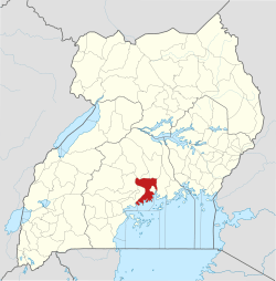
Kirinnya is a location in Kira Municipality in Wakiso District in the Central Region of Uganda.
Kirinnya | |
|---|---|
 Kirinnya Location in Uganda | |
| Coordinates: 00°19′12″N 32°40′30″E | |
| Country | |
| District | Wakiso District |
| City | Kira, Uganda |
| County | Kyaddondo |
| Constituency | Kyaddondo East |
| Government | |
| • Member of parliament | Ibrahim Semujju Nganda |
| Elevation | 3,810 ft (1,160 m) |
Location
Kirinnya is located in Kirinnya Ward in south-eastern Kira Municipality. Kirinnya is approximately 12 kilometres (7.5 mi), by road, east of downtown Kampala, Uganda's capital and largest city.[1] Kirinnya is bordered by Bweyogerere to the north, Namanve to the north-east, Namilyango to the east, Murchison Bay to the south, and Butabika to the west and north-west. The coordinates of Kirinnya are 0°19'12.0"N, 32°40'30.0"E (Latitude:0.3200; Longitude:32.6750).[2]
Overview
Kirinnya is a middle-class residential neighborhood. In between the residential dwellings, are schools, churches, soccer fields, and one supermarket.
Points of interest
- Kirinnya Housing Estate - A development by Akright Projects Limited, the largest indigenous real estate developer in Uganda.[3] It consists of about 150 bungalows in a gated planned community.[3]
- St. Luke's Catholic Church
- Kirinnya Seventh Day Adventist Church
- St. John's Church - A place of worship affiliated with the Church of Uganda.
- Maama Manjeri Day and Boarding Primary School.
- St. John's Primary School - Affiliated with St. John's Church of Uganda.
References
- "Travel Distance Between Kampala And Kirinnya With Map". Globefeed.com. Retrieved 24 January 2015.
- Google. "Location of Kirinnya At Google Maps". Google Maps. Retrieved 24 January 2015.
- AKPL. "About Akright Kirinnya Housing Estate". Akright Projects Limited (AKPL). Archived from the original on 28 January 2015. Retrieved 24 January 2015.
External links
This article is issued from Wikipedia. The text is licensed under Creative Commons - Attribution - Sharealike. Additional terms may apply for the media files.