Kimwanyi
Kimwanyi is a neighborhood in Kira Municipality, Wakiso District, in the Buganda Region of Uganda.[1] Kimwanyi also refers to Kimwanyi Parish, in Kira sub-county, Kyaddondo County, Wakiso District.[1] It is one of the six parishes (wards) of Kira Municicipality, namely; Kimwanyi, Kira, Kyaliwajjala, Kireka, Bweyogerere and Kirinnya.[2]
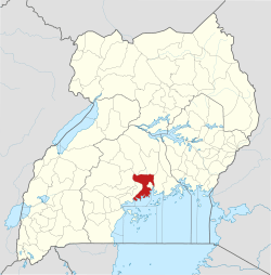
Kimwanyi | |
|---|---|
 Kimwanyi Location in Uganda | |
| Coordinates: 00°27′12″N 32°38′05″E | |
| Country | |
| District | Wakiso District |
| City | Kira, Uganda |
| County | Kyaddondo |
| Constituency | Kyaddondo East |
| Government | |
| • MP | Ibrahim Ssemujju Nganda |
| Elevation | 3,786 ft (1,154 m) |
| Population (2014 Estimate) | |
| • Total | 15,700 |
Location
Kimwanyi is in Kimwanyi Ward (Kimwanyi Parish), in northeastern Kira Municipality, Wakiso District, in Central Uganda. It is approximately 9 kilometres (6 mi), by road, north of the central business district of Kira Town.[3] This is approximately 22 kilometres (14 mi), by road, northeast of downtown Kampala, Uganda's capital and largest city.[4] The Kimwanyi neighborhood is bordered by Nakweero to the north, Kijabijo to the northeast, Kitukutwe to the east, Kiwologoma to the southeast, Bulindo to the south, Gayaza to the west, and Manyangwa to the northwest. The coordinates of Kimwanyi are 0°27'12.0"N, 32°38'05.0"E (Latitude:0.453336; Longitude:32.634733).[5] Kimwanyi sits at an average elevation of 1,154 metres (3,786 ft), above sea level.[6]
Overview
Kimwanyi is a rural neighborhood. In 2001, a law was passed incorporating the village into the newly created Kira Municipality, the second-largest urban center in Uganda, with a population of 313,761 according to the 2014 national census.[7]
The neighborhood is the location of Kimwanyi Umea Primary School, an elementary school, administered by the Uganda Muslim Community.[8] Also located there is the Namugongo Youth and Women Development Association (YWDAN), a non-profit organization.[9]
Population
In 2002, the national census estimated the population of Kira Municipality at 142,800. Kimwanyi Parish's population at the time was about 6,800 (approximately 5% of the total). In 2014, the Uganda Bureau of Statistics (UBOS), enumerated population of Kira at 313,761.[7] Given that data, it is estimated that the population of Kimwanyi Parish (Kimwanyi Ward) in 2014, was about 15,700.[7]
See also
References
- Lcmt.org (9 July 2018). "Map of Kimwanyi Parish, Kira sub-county, Wakiso District, Uganda". Lcmt.org. Retrieved 9 July 2018.
- Lcmt.org (9 July 2018). "Map of Kira Municipality (Kira Sub-county), Showing Its Six Constituent Parishes (Wards)". Lcmt.org. Retrieved 9 July 2018.
- Globefeed.com (9 July 2018). "Distance between Kira Town, Uganda and Kasaayi Primary School, Kimwanyi, Uganda". Globefeed.com. Retrieved 9 July 2018.
- Globefeed.com (9 July 2018). "Distance between Uganda Post Office, Kampala Road, Kampala, Uganda and Kasaayi Primary School, Kimwanyi, Kira Municipality, Uganda". Globefeed.com. Retrieved 9 July 2018.
- Google (9 July 2018). "Location of Kimwanyi, Kira Mnicipality, Uganda" (Map). Google Maps. Google. Retrieved 9 July 2018.
- Mapcarta (9 July 2018). "Elevation of Kimwanyi, Kira Town, Uganda". Mapcarta.com. Retrieved 9 July 2018.
- UBOS (27 August 2014). "The Population of The Regions of the Republic of Uganda And All Cities And Towns of More Than 15,000 Inhabitants". Citypopulation.de Quoting Uganda Bureau of Statistics (UBOS). Retrieved 24 December 2015.
- Nile Post Uganda (9 July 2018). "About Kimwanyi Umea Primary School". Kampala: Nile Post Uganda. Retrieved 9 July 2018.
- Global Hand Organization (24 December 2015). "Construct sanitary facilities for elderly in Uganda". Globalhand.Org. Retrieved 9 July 2018.