Kings Highway station (BMT Sea Beach Line)
Kings Highway is a local station on the BMT Sea Beach Line of the New York City Subway, located at the intersection of Kings Highway and West Seventh Street in Gravesend, Brooklyn. It is served by the N train at all times and several W trains during rush hours.
Kings Highway | |||||||||||
|---|---|---|---|---|---|---|---|---|---|---|---|
 | |||||||||||
| Station statistics | |||||||||||
| Address | Kings Highway & West Seventh Street Brooklyn, NY 11223 | ||||||||||
| Borough | Brooklyn | ||||||||||
| Locale | Gravesend | ||||||||||
| Coordinates | 40°36′11.33″N 73°58′48.83″W | ||||||||||
| Division | B (BMT) | ||||||||||
| Line | BMT Sea Beach Line | ||||||||||
| Services | N W | ||||||||||
| Transit connections | |||||||||||
| Structure | Open-cut | ||||||||||
| Platforms | 2 side platforms | ||||||||||
| Tracks | 4 (2 in regular service) | ||||||||||
| Other information | |||||||||||
| Opened | June 22, 1915[1] | ||||||||||
| Closed | January 18, 2016 (northbound reconstruction) July 31, 2017 (southbound reconstruction) | ||||||||||
| Rebuilt | May 22, 2017 (northbound reopening) October 29, 2018 (southbound reopening) | ||||||||||
| Station code | 077[2] | ||||||||||
| Accessible | not ADA-accessible; accessibility planned | ||||||||||
| Opposite-direction transfer available | Yes | ||||||||||
| Traffic | |||||||||||
| Passengers (2019) | 1,371,311[3] | ||||||||||
| Rank | 312 out of 424[3] | ||||||||||
| Station succession | |||||||||||
| Next north | Bay Parkway: N | ||||||||||
| Next south | Avenue U: N | ||||||||||
| |||||||||||
| |||||||||||
| |||||||||||


%26groups%3D_27d82e2f822340e70a2af0fd896e8340732d0e9d.svg)
Station layout
| G | Street level | Station building, entrance/exit, station agent, MetroCard machines |
| P Platform level |
Side platform | |
| Northbound local | ← ← | |
| Northbound express | No regular service | |
| Southbound express | Trackbed | |
| Southbound local | | |
| Side platform | ||
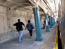
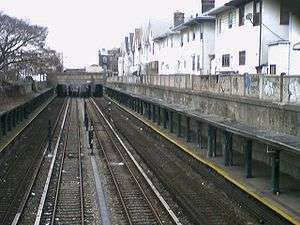
This open-cut station, which opened on June 22, 1915,[1] has four tracks and two side platforms. The two center express tracks are not normally used, but both tracks are available for rerouted trains. The platforms are carved within the Earth's crust on an open cut. The concrete walls are painted beige and the columns are teal.
This station has two entrances, both of which are beige station houses at street-level between West Seventh and West Eighth Streets above the tracks. Each one has a single staircase leading to each platform at either extreme ends. The main exit at the north end has a turnstile bank and token booth and leads to Kings Highway while the exit at the south end leads to Highlawn Avenue and is un-staffed, containing just HEET turnstiles and exit-only turnstiles.
At the southeast end of the station, switches allow trains to crossover between any of the four tracks. North of here, the Manhattan-bound express track continues with the rest of Sea Beach Line, but there are no signals until Eighth Avenue, so only one train is allowed to run along this stretch at a time. It is signaled for bi-directional service like other center tracks on three track lines throughout the system. The Coney Island-bound express track has been severed from the other three tracks between Eighth Avenue and this station and is unusable for service. South of this station, the two usable express tracks continue until they merge with the local tracks south of 86th Street station.
From January 18, 2016 to May 22, 2017, the Manhattan-bound platform at this station was closed for renovations.[4][5][6] The Coney Island-bound platform was closed for renovations from July 31, 2017,[7][8] to October 29, 2018.[9] In 2019, the MTA announced that this station would become ADA-accessible as part of the agency's 2020–2024 Capital Program.[10]
References
- "Through Tube to Coney, 48 Minutes: First Train on Fourth Avenue Route Beats West End Line Eleven Minutes". Brooklyn Daily Eagle. June 22, 1915. Retrieved June 29, 2015.
- "Station Developers' Information". Metropolitan Transportation Authority. Retrieved June 13, 2017.
- "Facts and Figures: Annual Subway Ridership 2014–2019". Metropolitan Transportation Authority. 2020. Retrieved May 26, 2020.
- "Two elevators coming to the N line during massive rehabilitation". October 4, 2013. Archived from the original on March 13, 2014. Retrieved May 24, 2014.
- "N Line Sea Beach - 2016". web.mta.info. Retrieved January 18, 2016.
- "9 Brooklyn N train stations to shut down for 14 months". am New York. January 14, 2016. Archived from the original on January 18, 2016. Retrieved January 18, 2016.
- Katinas, Paula (December 18, 2014). "Commuter headache: MTA to renovate N train stations". Brooklyn Daily Eagle. Archived from the original on October 27, 2018. Retrieved January 18, 2016.
- "New York City Subway Map" (PDF). mta.info. Metropolitan Transportation Authority. May 1, 2017. Archived from the original (PDF) on May 2, 2017. Retrieved May 2, 2017.
- DeJesus, Jaime (May 17, 2017). "Manhattan-bound service to return to N stations on Sea Beach Line". brooklynreporter.com. Retrieved May 18, 2017.
- "Manhattan-Bound Service Returns to N Stations on Sea Beach Line". www.mta.info. Metropolitan Transportation Authority. May 17, 2017. Retrieved May 26, 2017.
- "Transit & Bus Committee Meeting - November 2018" (PDF). mta.info. Metropolitan Transportation Authority. November 13, 2018. p. 164. Retrieved November 10, 2018.
- "Press Release - MTA Headquarters - MTA Announces 20 Additional Subway Stations to Receive Accessibility Improvements Under Proposed 2020-2024 Capital Plan". MTA. December 19, 2019. Retrieved December 25, 2019.
External links
| Wikimedia Commons has media related to Kings Highway (BMT Sea Beach Line). |
- nycsubway.org – BMT Sea Beach Line: Kings Highway
- Station Reporter — N Train
- The Subway Nut — Kings Highway Pictures
- Kings Highway entrance from Google Maps Street View
- Highlawn Avenue entrance from Google Maps Street View
- Uptown Platform from Google Maps Street View
| Sea Beach Line | |
|---|---|
| |