Kilkenny, New Hampshire
Kilkenny is a township located in Coos County, New Hampshire, United States. It lies entirely within the White Mountain National Forest. As of the 2010 Census, the township had a population of zero.
Kilkenny, New Hampshire | |
|---|---|
 A view of Unknown Pond with The Horn in the background, both of which are popular hiking destinations within the township. | |
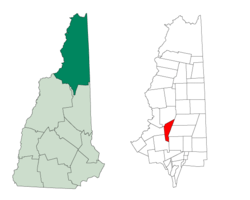 Location in Coos County, New Hampshire | |
| Coordinates: 44°29′43″N 71°23′33″W | |
| Country | United States |
| State | New Hampshire |
| County | Coos |
| Area | |
| • Total | 25.6 sq mi (66.3 km2) |
| Elevation | 4,160 ft (1,270 m) |
| Population (2010) | |
| • Total | 0 |
| Time zone | UTC-5 (Eastern) |
| • Summer (DST) | UTC-4 (Eastern) |
| Area code(s) | 603 |
In New Hampshire, locations, grants, townships (which are different from towns), and purchases are unincorporated portions of a county which are not part of any town and have limited self-government (if any, as many are uninhabited).
History
The town was granted to Jonathan Warner and others on June 4, 1774, containing 26,911 acres (108.90 km2). In 1840 it contained 19 inhabitants, and in 1856 it had 19 inhabitants and an area of 15,906 acres (64.37 km2), having a value of $20,000.[1] It was named after the town and county of Kilkenny in Ireland.
Kilkenny once included a large portion of what is now the eastern edge of Jefferson, tapering south into the area of Jefferson Notch at the foot of Mount Mitten. This included much of the area known as "Jefferson Highland" on the Portland Road (U.S. Route 2). By the 1870s, maps were showing the southern edge of Kilkenny as a line extending the northern border of Jefferson and Lancaster.[2] The 1896 topographic map, however, shows that the boundary had again been adjusted several miles south, to include Mount Waumbek and Pliny Mountain, uninhabited areas. Deeds in this area often refer to the "Kilkenny Addition".
On the 1935 topographic map, the "Upper Ammonoosuc Trail" crossed Kilkenny along Priscilla Brook and through the pass from the Keenan Brook area of Randolph, north of Pliny Mountain. This trail has since been abandoned, although a 2002 atlas of New Hampshire shows a "Priscilla Brook Trail" in the same location.
The Willard Bowl north of Mount Waumbek, drained by Garland Brook, was considered as a site for development of a ski area in 1971, when it was owned by former governor Hugh Gregg. On the 1896 topographic map, there was a B&M railroad spur up much of Garland Brook, to an elevation of 2,100 feet (640 m). By 1935, the tracks were gone.
Geography
According to the United States Census Bureau, the township has a total area of 25.6 square miles (66.3 km2), of which 0.04% is water.[3]
Kilkenny is home to Mount Waumbek of the Pliny Range and Mount Cabot of the Pilot Range, each over 4,000 feet (1,200 m) high (see Four-thousand footers), as well as several other peaks over 3,000 feet (910 m). The summit of Mount Cabot is the highest point in Kilkenny, at 4,160 feet (1,270 m) above sea level.
Kilkenny is bordered to the south and west by Jefferson, to the west by Lancaster, to the north by Stark, and to the east by Berlin and Milan. The West Branch of the Upper Ammonoosuc River originates on the eastern slope of the Pilot Range.
Demographics
| Historical population | |||
|---|---|---|---|
| Census | Pop. | %± | |
| 1800 | 18 | — | |
| 1810 | 28 | 55.6% | |
| 1820 | 24 | −14.3% | |
| 1830 | 27 | 12.5% | |
| 1900 | 47 | — | |
| 1920 | 2 | — | |
| 1960 | 0 | — | |
| 1970 | 0 | — | |
| 1980 | 0 | — | |
| 1990 | 0 | — | |
| 2000 | 0 | — | |
| 2010 | 0 | — | |
| Est. 2015 | 0 | [4] | |
| U.S. Decennial Census[5] | |||
As of the 2010 census,[6] there were no people living in the township.
Sources
- Town of Jefferson. Jefferson, New Hampshire, Before 1996 (1995). Littleton: Sherwin Dodge. p. 103.
References
- 1874 New Hampshire Gazetteer
- 1872 Railroad and Post Office Map of New Hampshire, and 1892 map of Jefferson
- "Geographic Identifiers: 2010 Demographic Profile Data (G001) - Kilkenny township, New Hampshire". United States Census Bureau. Retrieved November 9, 2011.
- "Annual Estimates of the Resident Population for Incorporated Places: April 1, 2010 to July 1, 2015". Archived from the original on June 2, 2016. Retrieved July 2, 2016.
- "Census of Population and Housing". Census.gov. Retrieved June 4, 2016.
- "U.S. Census website". United States Census Bureau. Retrieved 2008-01-31.
External links
Places adjacent to Kilkenny, New Hampshire | |
|---|---|
Municipalities and communities of Coös County, New Hampshire, United States | ||
|---|---|---|
| City |  Map of New Hampshire highlighting Coos County | |
| Towns | ||
| Townships |
| |
| CDPs | ||
| Other communities | ||