Dixville, New Hampshire
Dixville is a township in Coos County, New Hampshire, United States. The population was 12 as of the 2010 census.[1] In New Hampshire, locations, grants, townships (which are different from towns), and purchases are unincorporated portions of a county which are not part of any town and have limited self-government (if any, as many are uninhabited).
Dixville, New Hampshire | |
|---|---|
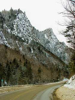 Dixville Notch in 2012 | |
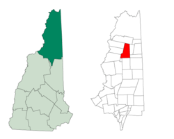 Location in Coos County, New Hampshire | |
| Coordinates: 44°55′00″N 71°16′58″W | |
| Country | United States |
| State | New Hampshire |
| County | Coos |
| Area | |
| • Total | 49 sq mi (126.9 km2) |
| • Land | 48.8 sq mi (126.4 km2) |
| • Water | 0.2 sq mi (0.5 km2) 0.36% |
| Elevation | 1,887 ft (575 m) |
| Population (2010) | |
| • Total | 12 |
| • Estimate (2018) | 11 |
| • Density | 0.24/sq mi (0.095/km2) |
| Time zone | UTC-5 (Eastern) |
| • Summer (DST) | UTC-4 (Eastern) |
| ZIP codes | 03576 |
| Area code(s) | 603 |
Dixville is the location of Dixville Notch State Park and The Balsams Grand Resort Hotel. It is part of the Berlin, NH–VT micropolitan statistical area. The village of Dixville Notch lies within Dixville.
Dixville will fall within the path of totality during the solar eclipse of April 8, 2024.[2]
History
Dixville was granted by the legislature to Timothy Dix Jr. in 1805 and contained about 29,340 acres (118.7 km2); the price was $4,500. It was organized for voting purposes in 1960, and the village of Dixville Notch is commonly known as the first place to cast votes in U.S. elections. The original grant included the eastern portion (north of Wentworth's Location) now known separately as Dix's Grant.[3]
Geography
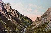
According to the United States Census Bureau, the township has a total area of 49.0 square miles (126.9 km2), of which 48.8 square miles (126.4 km2) is land and 0.2 square miles (0.5 km2), or 0.36%, is water.[4] The elevation of Dixville Notch is 1,887 feet (575 m) above sea level, in Dixville Notch State Park. (The term "notch" is the local equivalent of "pass" or "gap", and refers to a low place between mountains or mountain ranges.) Nearby Dixville Peak, at 3,482 feet (1,061 m), is the highest point in the township.
The township is served by New Hampshire Route 26.
Demographics
| Historical population | |||
|---|---|---|---|
| Census | Pop. | %± | |
| 1810 | 12 | — | |
| 1820 | 2 | −83.3% | |
| 1830 | 2 | 0.0% | |
| 1840 | 4 | 100.0% | |
| 1870 | 8 | — | |
| 1880 | 32 | 300.0% | |
| 1890 | 11 | −65.6% | |
| 1900 | 15 | 36.4% | |
| 1910 | 12 | −20.0% | |
| 1920 | 24 | 100.0% | |
| 1930 | 25 | 4.2% | |
| 1940 | 13 | −48.0% | |
| 1950 | 13 | 0.0% | |
| 1960 | 18 | 38.5% | |
| 1970 | 18 | 0.0% | |
| 1980 | 36 | 100.0% | |
| 1990 | 50 | 38.9% | |
| 2000 | 75 | 50.0% | |
| 2010 | 12 | −84.0% | |
| Est. 2017 | 11 | [5] | −8.3% |
| U.S. Decennial Census[6] | |||
As of the 2000 census,[7] there were 75 people, 10 households, and 10 families residing in the township. The population density was 1.5 people per square mile (0.6/km2). There were 36 housing units at an average density of 0.7 per square mile (0.3/km2). The racial makeup of the township was 98.67% White, with there being only one person of any other race, a Hispanic.
There were 10 households, all composed of married couples living together, and 40.0% of which had children under the age of 18 living with them. No households were made up of individuals. The average household and family size was 2.80.
In the township the population was spread out, with 9.3% under the age of 18, 1.3% from 18 to 24, 16.0% from 25 to 44, 8.0% from 45 to 64, and 65.3% who were 65 years of age or older. The median age was 76 years. For every 100 females, there were 74.4 males. For every 100 females age 18 and over, there were 61.9 males.
References
- United States Census Bureau, American FactFinder, 2010 Census figures. Retrieved March 23, 2011.
- "April 8, 2024". Great American Eclipse. Retrieved 2019-10-14.
- Coolidge, Austin J.; John B. Mansfield (1859). A History and Description of New England. Boston, Massachusetts: A.J. Coolidge. pp. 466–467.
coolidge mansfield history description new england 1859.
- "Geographic Identifiers: 2010 Demographic Profile Data (G001) - Dixville township, New Hampshire". United States Census Bureau. Retrieved November 9, 2011.
- "Annual Estimates of the Resident Population: April 1, 2010 to July 1, 2017 (PEPANNRES): Minor Civil Divisions – New Hampshire". Archived from the original on February 13, 2020. Retrieved November 14, 2018.
- "Census of Population and Housing". Census.gov. Retrieved June 4, 2016.
- "U.S. Census website". United States Census Bureau. Retrieved 2008-01-31.
See also
- New Hampshire primary
Places adjacent to Dixville, New Hampshire | |
|---|---|
Municipalities and communities of Coös County, New Hampshire, United States | ||
|---|---|---|
| City |  Map of New Hampshire highlighting Coos County | |
| Towns | ||
| Townships |
| |
| CDPs | ||
| Other communities | ||