Kilcoy, Queensland
Kilcoy is a town and locality in the Somerset Region local government area in South East Queensland, Australia.[2][3]
| Kilcoy Queensland | |||||||||||||||
|---|---|---|---|---|---|---|---|---|---|---|---|---|---|---|---|
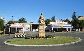 Main Street, Kilcoy | |||||||||||||||
 Kilcoy Location in Queensland | |||||||||||||||
| Coordinates | 26°56′35″S 152°33′50″E | ||||||||||||||
| Population | 1,898 (2016 census)[1] | ||||||||||||||
| Postcode(s) | 4515 | ||||||||||||||
| Location |
| ||||||||||||||
| LGA(s) | Somerset Region | ||||||||||||||
| State electorate(s) | Nanango | ||||||||||||||
| Federal Division(s) | Blair | ||||||||||||||
| |||||||||||||||
Geography
The township is on the D'Aguilar Highway, 94 kilometres (58 mi) north west of the state capital, Brisbane, and just to the north of Lake Somerset.
The topography directly north of the town is dominated by the mountains of the Conondale Range and covered by forests, some of which are protected in state forests and the Conondale National Park. Kilcoy is located in the Somerset Region.
The town's industry mainly revolves around beef, with 1/3 of the primary school's population made of immigrants who came for work in the Kilcoy Pastoral centre.
Climate
The Somerset region experiences a humid subtropical climate (Köppen climate classification Cfa) with hot and humid summers and mild to warm winters with cool overnight temperatures.
Median monthly rainfall at the Post Office weather Station in Kilcoy since records began in 1890 is 76.36 millimetres (3.006 in). The highest recorded annual rainfall was 1,422.4 millimetres (56.00 in) in 1893, the year of the 1893 Brisbane flood also known as the Black February floods.
Records of rainfall for the year of the 2010–11 Queensland floods in South East Queensland and for the period February 2010 to January 2011 are incomplete.
Rainfall in January 2013, another year of floods was 364.4 millimetres (14.35 in).[4]
History
Aboriginal history
The Aboriginal people of the Brisbane River Valley and Kilcoy region are the Jinibara People, traditionally a nation of five clans: the Dungidau centred in the Kilcoy region and the junction of the Stanley and Brisbane Rivers; the Dala or Dallumbara clan inhabiting the Conondale Range west to the Brisbane River; the Gurumngar around the southern end of the D’Aguilar Range; the Nalbo along the Maleny-Mapleton escarpment and the Dungibara on the Upper Brisbane River.[5][6]
Duungidjawu (also known as Kabi Kabi, Cabbee, Carbi, Gabi Gabi) is an Australian Aboriginal language spoken on Duungidjawu country. The Duungidjawu language region includes the landscape within the local government boundaries of Somerset Region and Moreton Bay Region, particularly the towns of Caboolture, Kilcoy, Woodford and Moore.[7]
Kilcoy was the heartland of the Jinibara People and the name comes from a patch of lawyer cane (jini) on Mount Kilcoy;[8] 'bara' means' people' or 'folk'; thus Jinibara are the 'People of the Lawyer cane'. Kilcoy was known as Bumgur, meaning the 'blue cod'.[9]
The Kilcoy region is a rich Aboriginal cultural landscape. Mount Archer was known as Buruja, and also the name of a wetland near Villeneuve that was one of the main camps of the Dungidau clan. Bora rings existed at 'Wellcourt' on Somerset Dam and at Sandy Creek east of Kilcoy, Oaky Creek and Waraba Creek.[10]
The junction of the Brisbane and Stanley Rivers was known as Gunundjin, meaning a 'hollow place', and a sacred place, called Gairnbee Rock, recalled a dreaming story of a girl who went swimming there and was turned by her father, a gundir (clever man) by magic into a rock to save her from a dangerous evil spirit.[11] The Stanley River was also called Gairnbee, meaning the water gum.[12] The Brisbane River was known as Mairwar or Mairrwarrh, meaning 'platypus' in Dungidau.
European settlement
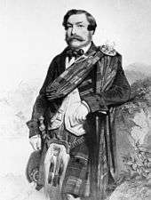
The locality was originally called Hopetown after early settler Captain Louis Hope. In 1841, brothers Evan[13] and Colin Mackenzie, from the town of Kilcoy in Scotland, took up land west of Durundur (in the Stanley River valley) and began grazing sheep soon after land was opened to free settlement.[14] They renamed it after their home town.[15] They sold the property to Charles A. Atherton in 1849. Atherton in turn sold it to Captain Hope and John Ramsay in 1854. The partnership broke up ten years later, and Hope became sole owner and built the Kilcoy Station homestead of bricks, made on the property, and red cedar. He stayed on in Kilcoy until 1900.[14] Station managers for Captain Hope were Bryant about 1860, Captain Talbot, 1864 and William Butler from 1871 until the sale, where he purchased the homestead block.[14] Hopetoun Post Office opened on 1 December 1892 (a Kilcoy receiving office had been open from 1889) and was renamed Kilcoy in 1907.[16]
Aboriginal massacre
In 1842 on the outskirts of Kilcoy Station owned by MacKenzie, 30–60 aborigines of the Gubbi Gubbi tribe, two Djindubari and some men from the Dalla tribe[17] died from eating flour that settlers had laced with strychnine or arsenic.[18][19]
Up until the early 1990s Mackenzie himself was a prime suspect but recent research suggests that he himself was probably not responsible for the massacre, since he was in Sydney at the time. The Mackenzies were admonished for this mass killing by Attorney-General John Hubert Plunkett (1802–1869), who threatened prosecution if an official complaint was lodged. Though MacKenzie's involvement was never verified, this incident was mentioned in a select committee in 1861 and repeated by W. Coote in 1867. The English overseer disappeared upon Mackenzie's return. Mackenzie organised the conspiracy of silence to protect the Englishman.
Establishment of township
Towards the end of the 1800s large properties and Government leases began to be divided up for closer settlement. Blocks capable of supporting a family were eagerly sought after, fenced and cleared. The main source of income for these settlers was dairying. In 1877, 2,240 acres (910 ha) were resumed from the Kilcoy pastoral run and offered for selection on 19 April 1877.[20]
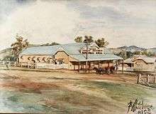
The site of the 'Town of Kilcoy' was surveyed by W. E. Hill by April 1888, and the first land sale was on 6 November that year.[14] The township quickly developed at the junction of Sheep Station and Kilcoy Creeks to service these settlers and their families.[14] On 1 December 1892, a post office was opened at Kilcoy, and named Hopetoun post office, after Louis Hope (the uncle of the first Governor General of Australia, Lord Hopetoun, who was a visitor to Kilcoy Station).[21] The township was referred to unofficially as Hopetoun. In 1908 the post office name was changed to Kilcoy, to avoid incorrect mail distribution to other towns of the same name in Victoria and Western Australia.[14]
By the 1890s the only original lease country left was in the Mt Kilcoy and Sandy Creek districts, part of Durundur Station. This country was not opened for settlement until 1902.[22]
Early schools
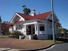
Kilcoy's first Provisional School was opened in 1884 at Sheep Station Creek, some five to six miles north of Kilcoy Homestead, the name changing to Sheep Station Creek Provisional School in 1892 when the Kilcoy School opened its doors in Hope Street in Kilcoy.[22][23] At that time there were still no subdivisions north of William Street as that was part of Kilcoy Station which was sold up in 1907.[24] The first Post Office was built in rented premises in Royston Street in 1892, the official Post Office in Kennedy Street still being some 21 years into the future.[21] Hopetoun Post Office opened on 1 December 1892 (a receiving office had been open from 1889) and was renamed Kilcoy in 1907.[16]
Timber industry

Timber milling operations were established as early as 1877, with Frank Nicholson building at Villeneuve, followed by James Green (1888), Hancock Brothers (1897), George Seeney and William and Stan Kropp in the same vicinity.[14] The turn of the century saw a huge increase in activity as Hancock & Gore timber mill began operation.[24]
Establishment of Kilcoy Shire Council
In 1912 the Shire of Kilcoy was formed, and the area became independent from the Caboolture Shire.[21][25]
Railway
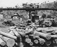
The establishment of the railway line in 1913 created a surge in the timber industry with more mills opening near Kilcoy (Bert Woodrow – c. 1916; Thurecht Brothers – c. 1918, George Payne – c. 1919) and at Louisavale (1912), Monsildale (1912) and Yednia (early 1900s). The rural areas within a relatively small radius of Kilcoy township catering for the settlers laboring in the industries of dairy, cattle and timber were flourishing with cultural activity and those early years around the turn of the century witnessed small schools and in some cases thriving villages spring up in West Vale (1887–1910), Villeneuve (1902–1960), Hazeldean (Stanley River, 1898–1973), Gregors Creek (1896–1963), Woolmar (1894–1941), Louisavale (1915–1940), Monsildale (1913–1922 and 1941–1961), Jimna (1923–2006), Yednia (1911–1946), Sheep Station Creek (1884–1942), Somerset at upper Mount Kilcoy (1915–1943), Mount Kilcoy (1909) and Sandy Creek (Winya, 1918–1960).[22]
Social development

Kilcoy became a prosperous town providing all the services required to maintain all needs of the district. With distance travel still not largely contemplated, nor in most cases desired, social, sporting and community-based clubs and organizations were established.
Somerset Dam

Somerset Dam was constructed between 1935 and 1959 with suspension of construction during the Second World War. The dam is situated on the Stanley River approximately 220 kilometres (140 mi) upstream from the mouth of the Brisbane River.
Construction of the Somerset Dam created jobs and in 1953, the Kilcoy Pastoral Company established an abattoir in the town.[26]
Native title
One of the most famous Aboriginal people in Queensland's history, Gaiarbau, (known as Willie MacKenzie), was born at Kilcoy in the 1870s. He died in a Salvation Army Home in Brisbane and was buried on 24 June 1968 in Mt Gravatt Cemetery.[27]
In the 1950s he recorded a series of tapes with Dr L.P. Winterbotham of the University of Queensland, that today provides one of the most detailed understandings of Aboriginal culture in southeast Queensland.[11]
This evidence of connection to the region assisted the Jinibara people in being granted Native Title by the Federal Court of Australia in 2012.
Decline
In the 1960s, road transport ensured the demise of the railway line (1964) and the old Kilcoy yard was converted many years later into a park known as Yowie Park.[22] Deregulation of the dairy industry has caused a lot of these small farms to become unviable. The total population for the wider area serviced by the town at the 2011 Australian Census was 4,840.[28]
A sand mining operation was proposed for the town in 2011,[29] but the application was withdrawn on 31 October 2012 following strong opposition by the local residents.
Heritage listings
Kilcoy has a number of heritage-listed sites, including Kilcoy Homestead on Kilcoy-Murgon Road.[30]
Culture
Most of Kilcoy's residents are employed servicing the surrounding pastoral area. (According to the 2011 census, Kilcoy had a population of 1,714.)[31]
Amenities
The Somerset Regional Council operates a public library at 15 Kennedy Street.[32] The current library facility opened in 2011.[33]
The Kilcoy branch of the Queensland Country Women's Association meets at the QCWA Hall at 33 Rose Street.[34]
Religion
There is an Anglican church in Kilcoy, St Mary's.[35]
The local Roman Catholic Church has a strong ecumenical focus and maintains a close relationship with the Anglican church.[36]
There are four other Protestant churches in the town: the Kilcoy Wesleyan Methodist Church,[37] the Kilcoy United Pentecostal Church,[38] the Kilcoy Uniting Church[39] and the Kilcoy Seventh Day Adventist Church.[40]
Notable residents
- Merri Rose – politician (Labor Party)
See also
References
- Australian Bureau of Statistics (27 June 2017). "Kilcoy (State Suburb)". 2016 Census QuickStats. Retrieved 29 January 2018.

- "Kilcoy - town (entry 18096)". Queensland Place Names. Queensland Government. Retrieved 2 April 2016.
- "Kilcoy - locality (entry 47780)". Queensland Place Names. Queensland Government. Retrieved 2 April 2016.
- Monthly rainfall: Kilcoy Post Office. Bureau of Meteorology. Retrieved 20 July 2015.
- Langevad, G. (ed.) (1983). Some Original Views around Kilcoy. Book I. The Aboriginal Perspectives; Book II: Queensland Ethnohistorical Transcripts Vol. 1, Brisbane: Gerry Langevad.
- Winterbotham, L. P., 1957. The Gaiarbau Story: Some native customs and beliefs of the Jinibara tribe as well as those of some of their neighbours in south-east Queensland, Brisbane: Archaeology Branch, Department of Aboriginal and Islanders Advancement.
-

- Steele, J. G., 1984. Aboriginal Pathways in Southeast Queensland and the Richmond River, St Lucia: University of Queensland Press.
- Gaiarbau cited in Winterbotham 1957
- Turnstone Archaeology, (2009). Southeast Queensland Archaeological and Cultural Site Location Data base, Sandstone Point: Turnstone Archaeology.
- Winterbotham, 1957
- Steele 1984
- Gibbney, H. J. (1974). "Mackenzie, Sir Evan (1816–1883)". Australian Dictionary of Biography. 5. Melbourne University Press. ISSN 1833-7538. Retrieved 1 April 2016 – via National Centre of Biography, Australian National University.
- Pioneers of the Kilcoy District Volume 1 Published 2002 by KDHS
- "NOMENCLATURE OF QUEENSLAND.— 164". The Courier-Mail. 8 April 1936. p. 14.
- Premier Postal History. "Post Office List". Premier Postal Auctions. Retrieved 10 May 2014.
- Meston, Archibald (20 October 1923). Old Moreton Bay tribes; their languages. Brisbane Courier. p. 18. Archived from the original on 16 March 2018.CS1 maint: ref=harv (link)
- Evans, Raymond (2007). A History of Queensland. Cambridge University Press. p. 54. ISBN 978-0-521-87692-6.
- "Leichhardt and the Aboriginal War | Leichhardt: A Scientist in a Strange Land". www.leichhardt.qm.qld.gov.au. Retrieved 1 July 2015.
- "Proclamations under the New Land Acts". The Brisbane Courier. Queensland, Australia. 2 March 1877. p. 3. Retrieved 19 February 2020 – via Trove.
- Pioneers of the Kilcoy District volume 2. 1900 to 1920. Published 2002 by KDHS
- Kilcoy District Historical Society records
- "Opening and closing dates of Queensland Schools". Queensland Government. Retrieved 18 April 2019.
- Pioneers of the Kilcoy District Volume 2 Published 2002 by KDHS
- "Pioneers of the Kilcoy District volume 1. 1900 to 1920. Published 2002 by KDHS
- "Pioneers of the Kilcoy District volume 3. 1920 to 1950, Published Kilcoy District Historical Society 2007
- Langevad 1983.
- Australian Bureau of Statistics (31 October 2012). "Kilcoy(Statistical Area Level 2)". 2011 Census QuickStats. Retrieved 20 July 2015.
- John Hammond (29 November 2011). Sandmining concern. Sunshine Coast Daily. Retrieved 5 July 2015.
- "Kilcoy Homestead (entry 600638)". Queensland Heritage Register. Queensland Heritage Council. Retrieved 12 July 2013.
- Australian Bureau of Statistics (31 October 2012). "Kilcoy (Urban Centre/Locality)". 2011 Census QuickStats. Retrieved 5 July 2015.
- "Kilcoy Library". Public Libraries Connect. 3 February 2016. Archived from the original on 19 January 2018. Retrieved 19 January 2018.
- "Public Libraries Statistical Bulletin 2016–17" (PDF). Public Libraries Connect. State Library of Queensland. November 2017. p. 15. Archived (PDF) from the original on 30 January 2018. Retrieved 30 January 2018.
- "Branch Locations". Queensland Country Women's Association. Retrieved 26 December 2018.
- "St. Mary's Anglican Church". Kilcoy Chamber of Commerce & Community. Archived from the original on 17 March 2018. Retrieved 25 October 2018.
- "Stanley River Catholic Church". Archived from the original on 27 July 2018. Retrieved 20 March 2018.
- "Kilcoy Wesleyan Methodist Church". Archived from the original on 7 August 2018. Retrieved 24 October 2018.
- "The Pentecostals of Kilcoy". Archived from the original on 7 August 2018. Retrieved 7 August 2018.
- "Kilcoy Uniting Church". Archived from the original on 12 March 2018. Retrieved 7 August 2018.
- "Kilcoy Adventist Church". Archived from the original on 7 August 2018. Retrieved 24 October 2018.
Further reading
- Lergessner, James G (2007), Death Pudding: The Kilcoy Massacre, James G. Lergessner, ISBN 978-0-646-47751-0
External links
| Wikimedia Commons has media related to Kilcoy, Queensland. |