Kanagawa-ku, Yokohama
Kanagawa-ku (神奈川区) is one of the 18 wards of the city of Yokohama in Kanagawa Prefecture, Japan. As of 2010, the ward had an estimated population of 230,401 and a density of 9,650 persons per km2. The total area was 23.88 km2.
Kanagawa 神奈川区 | |
|---|---|
| Kanagawa Ward | |
Flag | |
| |
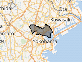
 Location of Kanagawa in Kanagawa | |
 Kanagawa | |
| Coordinates: 35°28′37″N 139°37′46″E | |
| Country | Japan |
| Region | Kantō |
| Prefecture | Kanagawa |
| City | Yokohama |
| Area | |
| • Total | 23.88 km2 (9.22 sq mi) |
| Population (February 2010) | |
| • Total | 230,401 |
| • Density | 9,650/km2 (25,000/sq mi) |
| Time zone | UTC+9 (Japan Standard Time) |
| - Tree | Magnolia kobus |
| - Flower | Tulip |
| Address | 3-8 Hirodaiota-chō, Kanagawa-ku Yokohama-shi, Kanagawa-ken 221-0824 |
| Website | Kanagawa Ward Office |
Geography
Kanagawa is located in eastern Kanagawa Prefecture, and northeast of the geographic center of the city of Yokohama.
Surrounding municipalities
History
Under the Nara period Ritsuryō system, the area that is now Kanagawa Ward became part of Tachibana District in Musashi Province. During the Edo period, the area was tenryō territory controlled directly by the Tokugawa shogunate, but administered through various hatamoto. The area prospered in the Edo period as Kanagawa-juku, a post station on the Tōkaidō connecting Edo with Kyoto. During the Bakumatsu period, Kanagawa was the location of the signing of the Convention of Kanagawa, which ended Japan’s national isolation policy and led to the normalization of diplomatic relations between the United States and Japan. The subsequent Treaty of Amity and Commerce (United States–Japan) led to the establishment of a treaty port for foreign commerce and settlement, which was initially stipulated to be Kanagawa. However, for security reasons, the actual settlement was established at neighboring Yokohama (present day Naka Ward). The Namamugi Incident, which led to the 1863 Anglo-Satsuma War, occurred in Kanagawa.
After the Meiji Restoration, the area was transferred to the new Kanagawa Prefecture in 1868. Kanagawa was connected to Yokohama and Tokyo by train in 1872, and was proclaimed a town on April 1, 1889. On April 1, 1901, it was absorbed into neighboring Yokohama. Kanagawa suffered severe damage from the 1923 Great Kantō earthquake. On October 1, 1927, it became Kanagawa Ward within the city of Yokohama. The area again destroyed during World War II, first being bombed during the Doolittle Raid of 1942, and finally being completely devastated during the massive Yokohama air raid of May 29, 1945. Kanagawa Ward soon rebuilt after the end of the war, although large portions of its territory remained under the control of the United States military until the 1970s.
Economy
Kanagawa Ward is a regional commercial center and bedroom community for central Yokohama and Tokyo. The coastal area is part of the Keihin Industrial Zone, and is the most industrialized region within Yokohama. Major factories are operated by Nissan, JVC, Nippon Petroleum Refining Co., Ltd., Nippon Flour Mills, Showa Denko, Asahi Glass Co. Mazda has a research and development center in Kanagawa-ku.[1]
Transportation
Railroads
- East Japan Railway Company –Yokohama Line
- East Japan Railway Company - Keihin-Tōhoku Line
- Keihin Electric Express Railway - Keikyū Main Line
- Keikyū Shinkoyasu - Koyasu - Kanagawa-Shinmachi - Naka-Kido - Kanagawa
- Tokyu Corporation - Tōkyū Tōyoko Line
- Yokohama City Transportation Bureau – Blue Line
Highways
- Daisan Keihin
- Shuto Expressway
- Route 1
- Japan National Route 15
Prefecture roads
- Kanagawa Prefecture Road 2
- Kanagawa Prefecture Road 21
- Kanagawa Prefecture Road 13
- Kanagawa Prefecture Road 111
Education
Colleges and universities:
Primary and secondary schools
Public senior high schools:
- Yokohama Suiran High School
- Kanagawa Sohgoh High School
- Kanagawa Technical High School
- Shirosato High School
Public junior high schools:
|
|
Public primary school:
|
|
|
|
|
International schools:
- Kanagawa Korean Jr./ Sr. High School – North Korean school[2][3]
- Yokohama Korean Primary School (横浜朝鮮初級学校) - Also a North Korean school[3] – Kindergarten and primary school[4] Private Schools:
Private Schools:
Asano High School
Local attractions
- Hama Wing
- Mitsuzawa Stadium
Noted people from Kanagawa Ward
- Hiroshi Abe, actor
- Tetsurō Degawa, comedian
- Tomomi Itano, ex-AKB48
- Keiko Kishi, actress
- Kaori Takahashi, actress
- Junichi Tazawa, professional baseball player
- Tetsuya Yamaguchi, professional baseball player
References
- Kato, Yuzo. Yokohama Past and Present. Yokohama City University (1990).
- "Offices Archived 2009-10-07 at the Wayback Machine". Mazda. Retrieved on October 29, 2009.
- "information Archived 2016-03-04 at the Wayback Machine" [sic]. Kanagawa Korean Jr./ Sr. High School. Retrieved on October 13, 2015.
- "The Education System and Schools Archived 2013-07-27 at the Wayback Machine" (Archive). Government of Kanagawa Prefecture. Retrieved on October 13, 2015.
- "International schools Archived 2015-08-20 at the Wayback Machine". City of Yokohama. Retrieved on October 13, 2015.
External links
- Kanagawa Ward Office
- Kanagawa Ward Office (in Japanese)
- City of Yokohama statistics

| Wikimedia Commons has media related to Kanagawa-ku, Yokohama. |
Yokohama (capital) | ||
| Wards of Yokohama | ||
| Wards of Kawasaki | ||
| Wards of Sagamihara | ||
| Core city |
| |
| Special cities | ||
| Cities | ||
| Districts | ||
| Authority control |
|
|---|