Juchitán de Zaragoza
Juchitán de Zaragoza (Spanish pronunciation: [xutʃiˈtan de saɾaˈɣosa]; Spanish name; Isthmus Zapotec: Xabizende [ʒàbìˈzěndè]) is an indigenous town in the southeast of the Mexican state of Oaxaca. It is part of the Juchitán District in the west of the Istmo de Tehuantepec region. With a 2005 census population of 74,714 inhabitants, it is the fourth-largest city in the state (just barely behind Salina Cruz). The majority of the indigenous inhabitants are Zapotecs and Huaves. The town also serves as the municipal seat for the surrounding municipality, with which it shares a name. The municipality has an area of 414.64 km² (160.1 sq mi) and a population of 85,869, the state's third-largest in population.
Juchitán de Zaragoza | |
|---|---|
 | |
Juchitán de Zaragoza | |
| Coordinates: 16°26′N 95°01′W | |
| Country | |
| State | Oaxaca |
| Municipality | Juchitán de Zaragoza |
| Founded | 1486 Cosijopí (Zapotec king) |
| Government | |
| • Mayor | Mariano Santana Lopez Santiago |
| Area | |
| • Municipality | 415 km2 (160.1 sq mi) |
| Elevation | 30 m (100 ft) |
| Population (2005) | |
| • Total | 74,174 |
| • Demonym | Juchiteco(a) |
| Time zone | UTC-6 (Central (US Central)) |
| • Summer (DST) | UTC-5 (Central) |
| Postal code | 70000 |
| Area code(s) | 971 |
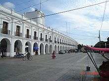
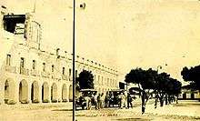
It is located 26 km northeast of the city of Tehuantepec. Its Palacio Municipal dates back to the middle of the 19th century and perhaps is the widest "palace" in Mexico with 31 arches in its front portal. Its main church is the Parroquia de San Vicente Ferrer (Parish of San Vicente Ferrer) which dates from the 17th century. To the west of the Palacio is a large market where local products can be seen and a local variant of the Zapotec language can be heard.[1]
Juchitán was the first Mexican town to elect a left wing pro-socialist municipal government in the 20th century, when Leopoldo de Gyves won the elections for mayor in 1980 against the Partido Revolucionario Institucional (PRI). The region's progressive politics and strong work ethic have cultivated a tradition of powerful women and an unusual tolerance for alternative gender roles. An article in Elle magazine called Juchitán "The Last Matriarchy". Many Juchitecas were angry about the article, saying it distorted what life is really like in Juchitán. Groups of women demanded that a local storekeeper stop selling the magazine issue.
History
The people of Juchitán have led some local revolts over time: In 1834, "Che Gorio Melendre", a native of Juchitán, directed a revolt against the government of Oaxaca, demanding the control of salt mines on the coast located at the southwest of Juchitán and for local autonomy of the county. The revolt was interrupted by the Mexican–American War in 1847. Irregular troops commanded by Melendre joined the resistance against the invasion. After the invasion by the United States], the governor of Oaxaca, Benito Juárez responded to the local demands of Che Gorio Melendre on May 19, 1850 by sending troops to burn the city of Juchitán and to assassinate their leader Melendre.
On September 5, 1866, during the French intervention in Mexico, the indigenous people of Juchitán, Unión Hidalgo, San Blas Atempa, and Ixtaltepec defeated the Royal French Army stationed in Tehuantepec. Most of the army of Porfirio Díaz, later President of Mexico, were natives of Juchitán. José Fructuoso Gómez, nicknamed Che Gómez directed a 1910 revolt in support of the Mexican Revolution, allied with Zapata and Villa. In the 1970s, a group of left wing students, workers and farmers organized with the intent of taking control of the local county through elections, instead of by force. In February 2001, Juchitán municipality received the caravan of Zapatista Army of National Liberation (EZLN).
The violent history of Juchitán involves the strategic geopolitical location of the area, which is located on the Isthmus of Tehuantepec, the thin part of Mexico between the Pacific Ocean and the Gulf of Mexico. The zone has been coveted by many countries since the McLane–Ocampo Treaty, which was signed in December 1859. Under the treaty, President Benito Juárez received a loan in exchange for the use of the isthmus of Tehuantepec by the United States. In the 1970s an attempt to resurrect the treaty, called the Alfa–Omega project, was aborted. In 2000, the project was finally approved as the Plan Puebla Panama.
Gamesa and Iberdrola are currently making important investments in Juchitán, to create a big wind power eolic park -called Proyecto La Venta II- able to produce at least 88 megawatts of energy. The project will make Juchitán the center of the alternative energies in Mexico becoming an example to the rest of Latin America as the eolic park would be the largest in all the region. This project has been criticized because of the lack of information given by Gamesa, Iberdrola and the Mexican Government about its possible ecological, political and cultural consequences on a region where its culture is based on the property of the land used by the Proyecto La Venta II.
In 2006, it was renamed as "Heroica Ciudad de Juchitán de Zaragoza" (Heroic City of Juchitán de Zaragoza) by the State Congress for its inhabitants' defense against the French invasion.
Culture
Citizens of Juchitán have also made contributions in the arts, such as painting, poetry, music, folk dance, and sculpture.
In May, residents celebrate the Fiesta de las Velas (Festival of the Candles) in honor of its patron saint San Vicente Ferrer, with a large procession.[1] Anya Peterson Royce. 2016 Prestigio y afiliación en una comunidad urbana: Juchitán, Oaxaca. Colección Xhono Gui’Chi’. Juchitán: Fundación Excellentiam. [as Anya Peterson R.; third edition of Royce 1975. ]
The Isthmus Zapotec, an indigenous people who comprise about 70 percent of the population of Juchitan, a city in the south of Mexico, practice a melding of Catholic and indigenous spiritual traditions. In a slide illustrated lecture, anthropologist Anya Peterson Royce shows how the Zapotec use flowers, processions and prayer in rituals that protect and guide spirits on their journey of dying. She also describes the Day of the Dead and Holy Week rituals and the role of the community healer.[2] Anya Peterson Royce. 2011 Becoming an Ancestor: The Isthmus Zapotec Way of Death. Albany, NY: SUNY University Press.
Climate
| Month | Jan | Feb | Mar | Apr | May | Jun | Jul | Aug | Sep | Oct | Nov | Dec | Year |
|---|---|---|---|---|---|---|---|---|---|---|---|---|---|
| Record high °C (°F) | 40.5 (104.9) |
41.5 (106.7) |
40.0 (104.0) |
46.0 (114.8) |
45.0 (113.0) |
41.0 (105.8) |
42.0 (107.6) |
42.0 (107.6) |
42.0 (107.6) |
42.0 (107.6) |
43.0 (109.4) |
40.5 (104.9) |
46.0 (114.8) |
| Average high °C (°F) | 29.8 (85.6) |
31.0 (87.8) |
32.4 (90.3) |
34.0 (93.2) |
34.7 (94.5) |
32.9 (91.2) |
32.6 (90.7) |
33.0 (91.4) |
32.2 (90.0) |
31.4 (88.5) |
30.9 (87.6) |
30.0 (86.0) |
32.1 (89.8) |
| Daily mean °C (°F) | 24.9 (76.8) |
25.5 (77.9) |
26.9 (80.4) |
28.6 (83.5) |
29.4 (84.9) |
28.2 (82.8) |
27.9 (82.2) |
28.1 (82.6) |
27.5 (81.5) |
26.9 (80.4) |
26.4 (79.5) |
25.4 (77.7) |
27.1 (80.8) |
| Average low °C (°F) | 19.9 (67.8) |
20.0 (68.0) |
21.4 (70.5) |
23.1 (73.6) |
24.0 (75.2) |
23.4 (74.1) |
23.2 (73.8) |
23.3 (73.9) |
22.9 (73.2) |
22.5 (72.5) |
21.8 (71.2) |
20.7 (69.3) |
22.2 (72.0) |
| Record low °C (°F) | 12.0 (53.6) |
10.0 (50.0) |
11.5 (52.7) |
11.0 (51.8) |
15.0 (59.0) |
15.0 (59.0) |
11.5 (52.7) |
14.5 (58.1) |
12.0 (53.6) |
16.0 (60.8) |
13.0 (55.4) |
10.6 (51.1) |
10.0 (50.0) |
| Average precipitation mm (inches) | 7.2 (0.28) |
3.6 (0.14) |
5.8 (0.23) |
5.8 (0.23) |
58.9 (2.32) |
228.1 (8.98) |
159.7 (6.29) |
169.6 (6.68) |
239.0 (9.41) |
75.0 (2.95) |
20.1 (0.79) |
5.6 (0.22) |
978.4 (38.52) |
| Average precipitation days (≥ 0.1 mm) | 1.0 | 0.5 | 0.6 | 0.6 | 4.1 | 11.8 | 8.5 | 8.8 | 11.2 | 4.7 | 1.2 | 0.5 | 53.5 |
| Source: Servicio Meteorológico National[3] | |||||||||||||
The municipality
As municipal seat, Juchitán has governing jurisdiction over the following communities:
15 de Agosto, 5 de Septiembre, Álvaro Obregón, Cerro Cristo, Charis, Chicapa de Castro, Colonia 19 de Marzo (Colonia San José), Colonia de la Amistad, Colonia Jesús González Cortaza, Colonia José Yola, Colonia Mariano Montero, Colonia San Vicente, Colonia Santa Rosita, Dos Arbolitos, Dos Hermanos, El Caballero Burro, El Chamizal (Toledo Cueto), El Chaparral, El Porvenir, El Tamarindo, Emiliano Zapata, Esquipulas 1, Esquipulas 2, Estero Guiee, Gaspar Torres Urbieta, Huanacastal, La Esperanza, La Estancia (Santa Cecilia), La Guadalupana, La Liebre (Paraje la Liebre), La Negrita, La Providencia, La Venta, La Ventosa 1, La Ventosa 2, Los Aguacates, Los Cocos Los Ordaz II, Los Vicentes Minerva, Onésimas (Argelino Solórzano), Parada San Vicente, Pepe y Lolita, Piedra Larga, Playa San Vicente, Primera Curva, Rancho Adelma, Rancho Babel López Sánchez, Rancho Chuvalessa, Rancho de los Vásquez (Colonia Palomar), Rancho Domitilo Marquez, Rancho Don Cutberto, Rancho el Ángel, Rancho Esquipulas, Rancho Francisco Rancho Guadalupe, Rancho Juanita, Rancho Lucita, Rancho Martín Vicente, Rancho Nemesio Valdivieso López, Rancho San Antonio, Rancho San Luis, Rancho Torres, Río Viejo (Mojonera), Salinas Santa Cruz, San Antonio, San Isidro, San José, Santa Clara, Santa Fe 1, Santa Fe 2, Santa Lucía, Santa María del Mar, and Santa Rita
2017 Chiapas earthquake
Shortly before midnight on 7 September, the 2017 Chiapas earthquake struck off the coast of Chiapas, registered at either 8.1.[4] or 8.2.[5] The historic earthquake was said to have been the strongest in Mexico in a century.[5]
Juchitán de Zaragoza, on the Oaxacan coast, was one of the cities most damaged by the earthquake.[6] Entire streets were destroyed,[7] its 1860 municipal palace suffered notable destruction, with a large part of the building completely collapsed.[8] In the aftermath of the quake, a resident retrieved the national flag of Mexico and placed it on top of the rubble - the image quickly went viral and became a symbol of patriotism and national unity in the disasters-stricken nation.[9]
References
- Quintanar Hinojosa, Beatriz (August 2007). "Istmus de Tehuantepec". Guía México Desconocido: Oaxaca. 137: 92.
- Anya Peterson Royce, "Isthmus Zapotec on death, healing and pilgrimage", Catholics & Cultures updated July 20, 2016
- "NORMALES CLIMATOLÓGICAS 1951-2010" (in Spanish). National Meteorological Service of Mexico. Archived from the original on March 3, 2016. Retrieved December 10, 2012.
- "8.1-magnitude earthquake off coast of Chiapas, Mexico". Mexico News Daily. 2017-09-08. Retrieved 2017-09-08.
- MALKIN, SEMPLE, AHMED, ELISABETH, KIRK, AHMED (8 September 2017). "Mexico Earthquake, Strongest in a Century, Kills Dozens". New York Times. Retrieved 8 September 2017.CS1 maint: multiple names: authors list (link)
- Embargo, Redacción / Sin. "El sismo se ensañó con Juchitán, Oaxaca: 30 muertos, y cientos de personas pierden sus hogares". SinEmbargo MX (in Spanish). Retrieved 2017-09-08.
- "Juchitán pide ayuda ante la tragedia por sismo (Videos) - Proceso". Proceso (in Spanish). 2017-09-08. Retrieved 2017-09-08.
- "Palacio Municipal de Juchitán, antes y después del terremoto". El Informador (in Spanish). Retrieved 2017-09-08.
- Redacción (2017-09-08). "Bandera sobre ruinas de Juchitán, símbolo de unión tras temblor en México". Huffington Post (in Spanish). Retrieved 2017-09-08.
External links
| Wikimedia Commons has media related to Juchitán de Zaragoza. |
- Historia de Tehuantepec, Historia de Salina Cruz, Noticias del Istmo
- Juchitán de Zaragoza municipal site
- EZLN arrives in Juchitan (26 February 2001
- Juchitán and the Authentic Searchers for Danger The ultimate Oaxaca travel guide
- Consejo Nacional de Energía Information about eolic energy available in Oaxaca
- Pueblos indígenas de México Zapotecos of the Isthmus monography
|