2017 Chiapas earthquake
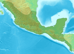
The 2017 Chiapas earthquake struck at 23:49 CDT on 7 September (local time; 04:49 on the 8th UTC) in the Gulf of Tehuantepec off the southern coast of Mexico, near state of Chiapas, approximately 87 kilometres (54 mi) southwest of Pijijiapan (alternately, 101 kilometres (63 mi) south-southwest of Tres Picos),[4] with a Mercalli intensity of IX (Violent).[5] The magnitude was estimated to be Mw8.2.[1]
.jpg) | |
 | |
| UTC time | 2017-09-08 04:49:19 |
|---|---|
| ISC event | 611600536 |
| USGS-ANSS | ComCat |
| Local date | 7 September 2017 |
| Local time | 23:49:21 CDT |
| Magnitude | 8.2 Mw[1] |
| Depth | 50.1 km (31.1 mi) |
| Epicenter | 15.068°N 93.715°W |
| Type | Dip-slip (normal) |
| Areas affected | Mexico, Guatemala[2] |
| Max. intensity | IX (Violent) |
| Tsunami | Yes |
| Aftershocks | 3,831[3] |
| Casualties | 98 dead, 300+ injured |
The earthquake caused all of Mexico City to tremble, prompting people to evacuate after the early warning system was triggered.[5] It also generated a tsunami with waves 1.75 metres (5 ft 9 in) above tide level;[6] and tsunami alerts were issued for surrounding areas.[7] Mexico's president called it the strongest earthquake recorded in the country, in a century.[8] It was also the second strongest recorded in the country's history, behind the magnitude 8.6 earthquake in 1787,[9] and the largest recorded globally in 2017.[10]
Tectonic setting
The Gulf of Tehuantepec lies above the convergent boundary where the Cocos Plate is being subducted below the North American Plate at a rate of 6.4 cm/yr (2.5 in/yr).[11][12]
Background
On 6 September, several earthquake alarms in Mexico City were mistakenly activated and this lead to the evacuation of buildings. The incident prompted a review of the system.[13]
Earthquake

According to the National Seismological Service (SSN) of Mexico, the epicenter was located in the Gulf of Tehuantepec, about 137 kilometres (85 mi) southeast of Tonalá, Chiapas.[14] The United States Geological Survey (USGS) reported that the epicenter was about 87 kilometres (54 mi) southwest of Pijijiapan, Chiapas.[1] The hypocenter was about 45 kilometres (28 mi) underground, deeper than usual for a relatively new subduction zone.[15] The SSN reported a measurement of M 8.2,[14] while the USGS also reported a M 8.2 earthquake after correcting an earlier estimate of M 8.0.[1] The earthquake was a result of normal faulting within the Cocos Plate with a displacement of up to 10 metres (33 ft).[1][16] The entire thickness of the lithosphere of the Cocos Plate ruptured during the earthquake.[15]
The earthquake is the most powerful to be measured in Mexico since the 1985 Mexico City earthquake,[17][18] and is comparable to the 1932 Jalisco earthquakes.[19] Mexican President Enrique Peña Nieto called the earthquake the "largest in at least a century" and claimed that it was felt by 50 million people.[8][20]
Geophysicists at the National Autonomous University of Mexico speculated that the earthquake relieved stored pressure in the "Tehuantepec gap", making future earthquakes in the region less likely.[21]
Tsunami
A tsunami with waves of 1 m (3.3 ft) and higher was generated by the earthquake and was recorded at Salina Cruz;[22] A tsunami wave of 1.75 m (5.7 ft) was reported in Chiapas.[6] The Pacific Tsunami Warning Center issued a warning for the entire Pacific coast of Central America, also extending south to Ecuador.[8][23]
Aftershocks
In the hour following the earthquake, at least 12 aftershocks were recorded by the USGS.[24] As of 00:30 September 14 (UTC Time), the National Seismological Service (SSN) has recorded at least 1,806 aftershocks, of up to a magnitude of 6.1.[3]
 Graph of aftershocks by magnitude
 Map of aftershocks as of 13 September
Red marks earthquakes over Mw 8.0 and orange over Mw 5.0.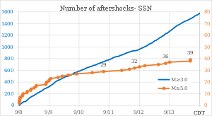 Number of aftershocks
| # | CDT time | Epicenter | Nearby landmarks | Depth | Mag. |
|---|---|---|---|---|---|
| Main | 7 September 2017 23:49:21 | 15.068°N 93.715°W | 87 km (54 mi) southwest of Pijijiapan | 69.7 km (43.3 mi) | 8.1 |
| 1 | 8 September 2017 0:01:38 | 15.867°N 94.088°W | 29 km (18 mi) southwest of Paredon | 35 km (21.7 mi) | 5.7 |
| 2 | 8 September 2017 0:17:42 | 15.547°N 94.489°W | 75 km (47 mi) south-southeast of San Francisco del Mar | 41.3 km (25.7 mi) | 5.4 |
| 3 | 8 September 2017 0:24:40 | 15.534°N 94.378°W | 77 km (48 mi) southwest of Paredon | 50.5 km (31.4 mi) | 5.2 |
| 4 | 8 September 2017 0:33:38 | 15.345°N 94.272°W | 87 km (54 mi) south-southwest of Paredon | 35.0 km (21.7 mi) | 5.2 |
| 5 | 8 September 2017 0:57:00 | 15.09°N 94.52°W | 137 km (85 mi) southwest of Tonalá | 21.0 km (13.0 mi) | 5.1 |
| 6 | 8 September 2017 1:08:47 | 15.45°N 94.78°W | 92 km (57 mi) southeast of Salina Cruz | 10.0 km (6.2 mi) | 5.0 |
| 7 | 8 September 2017 2:38:38 | 15.52°N 94.83°W | 83 km (52 mi) southeast of Salina Cruz | 50.0 km (31.1 mi) | 5.3 |
| 8 | 8 September 2017 2:59:57 | 15.58°N 94.91°W | 73 km (45 mi) southeast of Salina Cruz | 50.0 km (31.1 mi) | 5.2 |
| 9 | 8 September 2017 3:34:34 | 15.17°N 94.33°W | 130 km (81 mi) southwest of Tonalá | 16.0 km (9.9 mi) | 5.9 |
| 10 | 8 September 2017 6:25:56 | 15.90°N 95.11°W | 32 km (20 mi) southeast of Salina Cruz | 59.0 km (36.7 mi) | 5.0 |
| 11 | 8 September 2017 6:43:07 | 15.83°N 95.04°W | 42 km (26 mi) southeast of Salina Cruz | 59.0 km (36.7 mi) | 5.2 |
| 12 | 8 September 2017 9:24:59 | 15.78°N 94.93°W | 94 km (58 mi) southwest of Arriaga | 16.0 km (9.9 mi) | 5.3 |
| 13 | 8 September 2017 9:45:00 | 15.73°N 94.90°W | 60 km (37 mi) southeast of Salina Cruz | 97.0 km (60.3 mi) | 5.5 |
| 14 | 8 September 2017 12:02:55 | 15.77°N 94.94°W | 54 km (34 mi) southeast of Salina Cruz | 71.0 km (44.1 mi) | 5.0 |
| 15 | 8 September 2017 13:24:14 | 16.05°N 95.33°W | 20 km (12 mi) southwest of Salina Cruz | 75.0 km (46.6 mi) | 5.1 |
| 16 | 8 September 2017 13:57:23 | 16.17°N 95.24°W | 6 km (3.7 mi) southwest of Salina Cruz | 65.0 km (40.4 mi) | 5.2 |
| 17 | 8 September 2017 21:32:07 | 15.08°N 94.33°W | 127 km (79 mi) southwest of Tonalá | 20.0 km (12.4 mi) | 5.4 |
| 18 | 8 September 2017 22:08:14 | 15.71°N 94.54°W | 87 km (54 mi) southeast of Salina Cruz | 16.0 km (9.9 mi) | 5.3 |
| 19 | 8 September 2017 23:54:48 | 14.73°N 94.25°W | 154 km (96 mi) southwest of Pijijiapan | 20.0 km (12.4 mi) | 5.6 |
| 20 | 9 September 2017 0:22:16 | 15.52°N 94.85°W | 82 km (51 mi) southeast of Salina Cruz | 16.0 km (9.9 mi) | 5.2 |
| 21 | 9 September 2017 1:24:20 | 15.65°N 95.04°W | 61 km (38 mi) southeast of Salina Cruz | 17.0 km (10.6 mi) | 5.0 |
| 22 | 9 September 2017 7:17:40 | 15.79°N 94.93°W | 52 km (32 mi) southeast of Salina Cruz | 55.0 km (34.2 mi) | 5.4 |
| 23 | 9 September 2017 10:30:09 | 15.71°N 95.06°W | 54 km (34 mi) southeast of Salina Cruz | 26.0 km (16.2 mi) | 5.0 |
| 24 | 9 September 2017 15:26:16 | 15.65°N 94.91°W | 66 km (41 mi) southeast of Salina Cruz | 32.0 km (19.9 mi) | 5.0 |
| 25 | 9 September 2017 22:07:21 | 15.30°N 94.70°W | 111 km (69 mi) southeast of Salina Cruz | 15.0 km (9.3 mi) | 5.8 |
| 26 | 10 September 2017 10:28:50 | 15.21°N 94.57°W | 127 km (79 mi) southeast of Salina Cruz | 20.0 km (12.4 mi) | 5.0 |
| 27 | 11 September 2017 9:55:58 | 15.25°N 94.55°W | 124 km (77 mi) southeast of Salina Cruz | 16.0 km (9.9 mi) | 5.2 |
| 28 | 11 September 2017 16:09:13 | 15.05°N 94.24°W | 140 km (87 mi) southwest of Tonalá | 20.0 km (12.4 mi) | 5.2 |
| 29 | 11 September 2017 20:12:31 | 15.02°N 94.96°W | 126 km (78 mi) southwest of Tonalá | 34.0 km (21.1 mi) | 5.6 |
| 30 | 12 September 2017 0:08:45 | 15.01°N 93.98°W | 111 km (69 mi) southwest of Pijijiapan | 13.0 km (8.1 mi) | 5.3 |
| 31 | 12 September 2017 4:20:01 | 15.53°N 95.06°W | 73 km (45 mi) south of Salina Cruz | 16.0 km (9.9 mi) | 5.0 |
| 32 | 12 September 2017 15:07:30 | 15.37°N 94.80°W | 99 km (62 mi) southeast of Salina Cruz | 16.0 km (9.9 mi) | 5.0 |
Damage and aftermath

Within Chiapas, an estimated 1.5 million people were affected by the earthquake, with 41,000 homes damaged.[26][27] Jose Calzada,[28] Minister of Agriculture,[28] reported that at least 98 people had died in the earthquake,[28] including 78 in Oaxaca, 16 in Chiapas and 4 in Tabasco.[28] The Secretariat of the Interior declared a state of emergency for 122 municipalities in Chiapas,[29] and the Mexican Army was deployed to aid in disaster relief.[30] Schools were closed on 8 September in 11 states for safety inspections.[31] Damage in Veracruz was reported, meanwhile the state is expecting the arrival of Hurricane Katia on 9 September.[31] Hurricane Max made landfall in Guerrero state on 14 September, near the earthquake-stricken region.[32]
Buildings in Juchitán de Zaragoza, Oaxaca, closest to the epicenter, were "reduced to rubble" according to reports from the town's mayor.[33]
The earthquake also caused buildings to shake and sway in Mexico City, while also knocking out electricity for 1.8 million people.[26][31] There were reports of glass shattered at Mexico City International Airport.[34] An under construction highway bridge near Mexico City's new international airport collapsed due to the shaking.[35]
The epicenter was near Mexico's border with Guatemala, where the quake was felt in Guatemala City, and infrastructure damage was reported by CONRED in the nation's south-west.[2] President Jimmy Morales stated that one Guatemalan was killed.[36]
 President Enrique Peña Nieto inspecting damage to a home in Juchitán, Oaxaca
 Collection Center for the victims of the earthquake, Mexico City City Hall.
Response
On 11 September, Mexico recalled its aid to the United States, offered in the aftermath of Hurricane Harvey, to focus on earthquake recovery.[37]
United States President Donald Trump called Mexican President Enrique Peña Nieto on 14 September, a week after the earthquake, to express his condolences. Trump's delayed call, which he blamed on cellular signal problems, was criticized by some media outlets in both countries.[38]
References
- ANSS: Chiapas 2017.
- Cumes, William (7 September 2017). "Temblor de 7.7 grados sacude Guatemala". Prensa Libre (in Spanish).
- @SSNMexico (21 September 2017). "Hasta las 5:30 am del 21-sep: 34 réplicas (M4.0 la mayor) del sismo del 19-sep M7.1 y 3831 réplicas (M6.1 la mayor) del sismo del 7-sep M8.2" (Tweet) – via Twitter.
- ANSS. "M 8.1 – 87 km SW of Pijijiapan, Mexico". Comprehensive Catalog. U.S. Geological Survey. Retrieved 7 September 2017 ; subsequently redirected to ANSS. "M 8.2 – 101km SSW of Tres Picos, Mexico". Comprehensive Catalog. U.S. Geological Survey .
- "Earthquake of magnitude 8.1 strikes off Mexico's Pacific coast". BBC News. 8 September 2017. Retrieved 8 September 2017.
- Pacific Tsunami Warning Center (8 September 2017). "Tsunami Message Number 17". Ewa Beach, Hawaii: National Weather Service. Retrieved 8 September 2017.
- "Tsunami Message Number 5 (0653 UTC Fri Sep 8 2017)". National Weather Service (United States). 8 September 2017. Archived from the original on 8 September 2017. Retrieved 8 September 2017.
- Graham, Chris; Johnson, Jamie; Strange, Hannah; Badcock, James (8 September 2017). "Mexico hit by 'strongest earthquake in a century' as magnitude 8.2 tremor triggers tsunami waves – latest news". The Telegraph.
- Richard Hartley, Parkinson (8 September 2017). "Most powerful earthquake in 230 years hits Mexico sparking tsunami". Metro. Retrieved 8 September 2017.
- "World – M7+ in 2017". earthquake.usgs.gov. Retrieved 8 September 2017.
- Singh, S.K.; M. Ordaz; L. Alcantara; N. Shapiro; V. Kostoglodov; J. F. Pacheco; S. Alcocer; C. Gutierrez; R. Quaas; T. Mikumo; E. Ovando; J. Aguirre; D. Almora; J. G. Anderson; M. Ayala; C. Javier; G. Castro; R. Duran; G. Espitia; J. Estrada; E. Guevara; J. Lermo; B. Lopez; O. Lopez; M. Macias; E. Mena; M. Ortega; C. Perez; J. Perez; M. Romo; M. Ramirez; C. Reyes; R. Ruiz; H. Sandoval; M. Torres; E. Vazquez; R. Vazquez; J. M. Velasco & J. Ylizaturri (2000). "The Oaxaca earthquake of 30 September 1999 (MW = 7.5)" (PDF). Seismological Research Letters. 71 (1): 67–78. doi:10.1785/gssrl.71.1.67. Retrieved 8 September 2017.
- Taylor, Adam (8 September 2017). "Mexico's cataclysmic history of earthquakes". The Washington Post. Retrieved 8 September 2017.
- "Se activa, por error, alerta sísmica en CDMX; descartan sismo" [Seismic alert in CDMX is activated by mistake; disregard earthquake]. El Universal (in Spanish). 6 September 2017. Retrieved 7 September 2017.
- "Reporte de Sismo: Sismo del día 07 de Septiembre de 2017, Chiapas (M 8.2)" [Earthquake Report: Earthquake of 7 September 2017, Chiapas (M 8.2)] (PDF) (in Spanish). National Seismological Service. 8 September 2017. Archived from the original (PDF) on 8 September 2017. Retrieved 8 September 2017.
- Melgar D.; Ruiz-Angulo A.; Garcia E.S.; Manea M.; Manea V.C.; Xu X.; Ramirez-Herrera M.T.; Zaval-Hidalgo J.; Geng J. (2018). "Deep embrittlement and complete rupture of the lithosphere during the Mw8.2 Tehuantepec earthquake". Nature Geoscience. 11 (12): 955–960. doi:10.1038/s41561-018-0229-y.
- Osborne, Hannah (8 September 2017). "Biggest earthquake to hit Mexico in over a century moved fault by 32 feet". Newsweek. Retrieved 8 September 2017.
- Linthicum, Kate; Lin II, Rong-Gong (8 September 2017). "Mexican authorities report an 8.4 earthquake off southern coast, raising tsunami fears". The Los Angeles Times. Retrieved 8 September 2017.
- Schladebeck, Jessica (8 September 2017). "Mexico hit by 8.4 earthquake, tsunami warnings issued". New York Daily News. Retrieved 8 September 2017.
- Lafuente, Javier (8 September 2017). "Un fuerte terremoto sacude el sur de México" [A strong earthquake shakes southern Mexico]. El País (in Spanish). Madrid. Retrieved 8 September 2017.
- Partlow, Joshua (8 September 2017). "At least 58 killed in massive earthquake off Mexico coast". The Washington Post. Retrieved 8 September 2017.
- Wade, Lizzie (15 September 2017). "Unusual Mexico earthquake may have relieved stress in seismic gap". Science Magazine. 357 (6356): 1084. doi:10.1126/science.357.6356.1084. ISSN 1095-9203. OCLC 1644869. PMID 28912223. Retrieved 19 September 2017.
- "Mexico earthquake: mass evacuations after strongest tremor in a century". The Guardian. 8 September 2017. Retrieved 8 September 2017.
- "At least six die in huge Mexico quake, small tsunami triggered – Video". Retrieved 8 September 2017.
- Malkin, Elisabeth; Ramzy, Austin (8 September 2017). "Strong Earthquake Hits Off Mexico's Coast". The New York Times. Retrieved 8 September 2017.
- "Search Results". USDS.
- "Death toll rises to 60 in powerful Mexico earthquake". Associated Press. 9 September 2017. Retrieved 9 September 2017.
- "Thousands of homes wrecked by huge Mexican quake, death toll at 90". Reuters. 10 September 2017. Retrieved 10 September 2017.
- Times, Global. "Death toll from Mexico earthquake climbs to 98 – Global Times". www.globaltimes.cn. Retrieved 16 September 2017.
- Mandujano, Isaín (8 September 2017). "La Segob declara "emergencia extraordinaria" en 122 municipios de Chiapas por sismo" [Secretariat of the Interior declares "extraordinary emergency" in 122 Chiapas municipalities after earthquake]. Proceso (in Spanish). Retrieved 8 September 2017.
- Garcia, Dennis A. (8 September 2017). "Sedena aplica Plan DN-III-E en Chiapas y Oaxaca" [Sedena applies DN-III-E plan in Chiapas and Oaxaca]. El Universal (in Spanish). Retrieved 8 September 2017.
- Sherman, Cristopher; Castillo, Eduardo (8 September 2017). "'The house moved like chewing gum': Dozens killed in Mexico earthquake as country braces for hurricane". The National Post. Toronto. Associated Press. Retrieved 8 September 2017.
- "Hurricane Max lashes earthquake-hit area of southwest Mexico". Channel NewsAsia. 15 September 2017. Retrieved 15 September 2017.
- Cortes, Jose (8 September 2017). "At least 58 die in Mexico's strongest quake in 85 years". Reuters. Retrieved 8 September 2017.
- Malkin, Elisabeth; Ramzy, Austin (8 September 2017). "Mexico Earthquake, at 8.1 Magnitude, Is Felt for Hundreds of Miles". The New York Times. Retrieved 8 September 2017.
- Navarro, Andrea (13 September 2017). "In Mexico City Mud, Pena Nieto's $13 Billion Airport Project Bogs Down". Bloomberg News. Retrieved 14 September 2017.
- Linthicum, Kate; Sanchez, Cecilia (8 September 2017). "From toppled buildings to at least 32 deaths, Mexico's most powerful quake in years prompts chaos". The Los Angeles Times. Retrieved 8 September 2017.
- Agren, David (11 September 2017). "Mexico withdraws Harvey aid offer as it focuses on earthquake recovery". The Guardian. Retrieved 11 September 2017.
- Partlow, Joshua (14 September 2017). "Was it just the cell signal? Mexicans wonder why Trump took so long to offer his earthquake condolences". The Washington Post. Retrieved 19 September 2017.
External links
- M=6.1 Mexican aftershock strongly promoted by M=8.1 Chiapas mainshock – Temblor, Inc.
- The International Seismological Centre has a bibliography and/or authoritative data for this event.
- ReliefWeb's main page for this event.