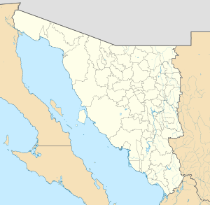
Caborca
Caborca (O'odham: Kawulk) is the municipal seat of the Caborca Municipality in the Mexican state of Sonora. The city has a population of 59,922, while the municipal population was 85,631 as of 2015.[2] Municipal boundaries are with Pima County, Arizona in the United States of America in the north, Altar in the east, Pitiquito in the southeast, Puerto Peñasco and Plutarco Elías Calles in the northwest, and the Gulf of California in the southwest. Caborca lies on Federal Highway 2, which connects the state's capital Hermosillo with the cities of Mexicali and Tijuana in the state of Baja California.
Heroica Caborca Kawulk | |
|---|---|
   | |
 Seal | |
 Heroica Caborca Heroica Caborca | |
| Coordinates: 30°43′N 112°09′W | |
| Country | |
| State | Sonora |
| Municipality | Caborca Municipality |
| Foundation | 1693 |
| Government | |
| • Type | Ayuntamiento |
| • Mayor | Librado Macías González |
| Elevation | 280 m (918 ft) |
| Population (2015)[1] | |
| • Total | 59,922 |
| • Demonym | Caborqueño |
| Time zone | UTC-7 (MST) |
| • Summer (DST) | UTC-7 (No DST observed) |
| Area code(s) | 637 |
| Website | www |
Climate
Caborca has a desert climate (Köppen climate classification BWh) with very hot summers and mild winters. The temperatures can climb above 38 °C in May and stay there until October. Because it has a very dry climate, strong winds can bring localized dust storms as well as "dust devils". Although rain is rare, when it happens it can bring a sudden deluge that causes brief localized flooding. Like the U.S. state of Arizona to the north, the area has a monsoon season in late summer that brings higher humidity and frequent dust storms or rain showers.
| Climate data for Heroica Caborca, Sonora (1951–2010, extremes (1950–2010) | |||||||||||||
|---|---|---|---|---|---|---|---|---|---|---|---|---|---|
| Month | Jan | Feb | Mar | Apr | May | Jun | Jul | Aug | Sep | Oct | Nov | Dec | Year |
| Record high °C (°F) | 31.0 (87.8) |
34.0 (93.2) |
40.0 (104.0) |
40.0 (104.0) |
45.0 (113.0) |
48.0 (118.4) |
46.5 (115.7) |
46.0 (114.8) |
44.0 (111.2) |
43.5 (110.3) |
35.0 (95.0) |
30.0 (86.0) |
48.0 (118.4) |
| Average high °C (°F) | 21.1 (70.0) |
22.4 (72.3) |
25.3 (77.5) |
29.5 (85.1) |
35.4 (95.7) |
40.0 (104.0) |
40.4 (104.7) |
39.0 (102.2) |
38.0 (100.4) |
32.3 (90.1) |
25.5 (77.9) |
21.2 (70.2) |
30.8 (87.4) |
| Daily mean °C (°F) | 13.1 (55.6) |
14.1 (57.4) |
16.6 (61.9) |
20.0 (68.0) |
24.7 (76.5) |
29.5 (85.1) |
32.0 (89.6) |
31.1 (88.0) |
29.5 (85.1) |
23.4 (74.1) |
16.9 (62.4) |
13.2 (55.8) |
22.0 (71.6) |
| Average low °C (°F) | 5.2 (41.4) |
5.9 (42.6) |
7.9 (46.2) |
10.4 (50.7) |
13.9 (57.0) |
19.1 (66.4) |
23.6 (74.5) |
23.4 (74.1) |
21.2 (70.2) |
14.5 (58.1) |
8.4 (47.1) |
5.2 (41.4) |
13.2 (55.8) |
| Record low °C (°F) | −3.5 (25.7) |
−3.5 (25.7) |
−1.5 (29.3) |
2.0 (35.6) |
6.0 (42.8) |
10.0 (50.0) |
15.0 (59.0) |
16.0 (60.8) |
13.0 (55.4) |
5.0 (41.0) |
−1.0 (30.2) |
−3.5 (25.7) |
−3.5 (25.7) |
| Average precipitation mm (inches) | 26.0 (1.02) |
12.9 (0.51) |
18.1 (0.71) |
6.7 (0.26) |
1.1 (0.04) |
1.5 (0.06) |
61.0 (2.40) |
72.2 (2.84) |
28.2 (1.11) |
18.0 (0.71) |
22.1 (0.87) |
33.4 (1.31) |
301.2 (11.86) |
| Average precipitation days (≥ 0.1 mm) | 3.2 | 2.7 | 3.1 | 0.9 | 0.4 | 0.4 | 5.0 | 5.2 | 3.0 | 1.6 | 1.5 | 3.8 | 30.8 |
| Source: Servicio Meteorológico Nacional (Mexico's Meteorogical Service) [3] | |||||||||||||
Health and educational infrastructure
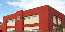
There is a hospital in the main town and several clinics spread out in surrounding communities. The educational infrastructure consists of over 150 schools, of which seven are secondary schools. There is one school of post-secondary education, a site of the University of Sonora and a campus of Conalep, a post-secondary technical institute.[4][5]
Economy
Agriculture is the most important economic activity with more than 1,000 km² of planted area. The main crops are grapes, cotton, and wheat. Despite the arid climate, wells are used for irrigated crops. The cattle herd is modest, concentrating on exporting calves to the United States.
Industry is growing with a scattering of maquiladoras. There is also some fishing on the 130 km long coastline, mainly of shrimp, while oysters are produced in the estuaries.
Tourism
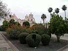
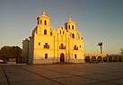
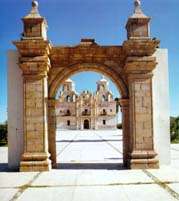
There is modest tourist potential with the beaches on the Gulf of California as well as the white mission churches, especially Nuestra Señora de la Concepción de Caborca in the municipal seat. The beach at El Desemboque is sought after by tourists desiring a less commercialized atmosphere.
Santo Tomás, a beachfront community, is also located in the Municipality of Caborca. Santo Tomás was originally established in 1960. This community features custom and semi-custom homes on beachfront, oceanview and desert view lots.[6]
Among Caborca's more popular and interesting attractions are the petroglyphs that were etched in stone by ancient inhabitants thousands of years ago.
Sister cities
History
The Hohokam inhabited the area from roughly 300 B.C. to 1400 A.D.[7]
The municipal seat was formed in the year 1688 as a mission town, by the Jesuit missionary Francisco Eusebio Kino on the point called Caborca Viejo (Old Caborca). In 1790, it was established on the site that it currently occupies, on the right (east) bank of the Asunción River. The place was inhabited by Tohono O'odham.
Father Kino was still the head when the mission town was completed in December 1692. The old site of the municipal seat is now known as Pueblo Viejo (Old Town).
In 1790, the seat was established at the place it now occupies. It was inhabited by Upper Pimas. The name of the municipality comes from "Kawulk", which means "hill with rocks and boulders".
In April 1857, during the Reform War, a force of American colonists, captained by Henry A. Crabb, was defeated and massacred by rebel forces of Ygnacio Pesquiera and Tohono O'odham warriors. Pesquiera had initially invited the Americans to settle in northern Sonora, to help the fight against the federal Mexican government, however, before the Crabb Expedition arrived in Sonora, Pesquiera's rebels defeated the federal troops and took over the state. Because of this, when the Crabb party arrived, Pesquiera's ordered his men to attack the Americans. Over the course of eight days, from April 1 to April 8, about 25 Americans and a reported 200 Mexicans and O'odham were killed in battle, at the end of which, some 55 captured Americans were executed by firing squad, including Henry Crabb.[8][9] In memory of the Crabb Massacre, the seat changed its name to Heróica Caborca in April 1948.
At the start of Mexican independence, it was the seat of a parish, under the area of Guadalupe de Altar for its civil administration. It obtained the status of Municipality at the end of the 19th century, assigned to the District of Altar (until districts were abolished by the Mexican constitution of 1917).
References
- http://cuentame.inegi.org.mx/monografias/informacion/son/territorio/div_municipal.aspx?tema=me&e=26
- "Número de habitantes. Sonora". Cuentame.inegi.org.mx. Retrieved 29 June 2018.
- "Servicio Meteorológico Nacional: Valores normales de 1971–2000 para Heroica Caborca, Sonora" (in Spanish). Servicio Meteológico Nacional. Archived from the original on 3 March 2016. Retrieved 24 November 2016.
- "Archived copy". Archived from the original on 1 December 2008. Retrieved 4 July 2007.CS1 maint: archived copy as title (link)
- "Archived copy". Archived from the original on 28 September 2007. Retrieved 4 July 2007.CS1 maint: archived copy as title (link)
- "Santo Tomas, Mexico, Beachfront Vacation Homes - Lots for Sale at Santo Tomas, Sonora, Mexico". Santotomas.com. Retrieved 29 June 2018.
- "Archived copy". Archived from the original on 28 September 2007. Retrieved 4 July 2007.CS1 maint: archived copy as title (link)
- HISTORIAN', BY THOMAS EDWIN FARISH, `ARIZONA. "CHAPTER XX. THE CRABB MASSACRE". Southwest.library.arizona.edu. Retrieved 29 June 2018.
- United States Department of State, pg. 69-72
Bibliography
- United States Department of State (1857–1861). Execution of Colonel Crabb and associates: Message from the President of the United States communicating official information and correspondence in relation to the execution of Colonel Crabb and his associates. James B. Steedman.
External links
- Enciclopedia de los Municipios de Mexico
- INEGI Mexican census
- Caborca, Ayuntamiento Digital (Official Website of Caborca, Sonora)
- Viva Caborca Website devoted to the promotion of Caborca (English)
- Mission of Caborca
- Sonora Turismo article on Caborca Spanish
- Heroica Caborca Visita Tu Sitio Web de Caborca
|