Joseph City, Arizona
Joseph City (elevation 5,000 ft) is an unincorporated community located in Navajo County, Arizona, United States. It is located on Interstate 40 about eighty miles east of Flagstaff and about thirty-five miles west of Petrified Forest National Park. In 2010, there were 1,386 inhabitants.[4]
Joseph City, Arizona | |
|---|---|
Census-designated place (CDP) | |
 | |
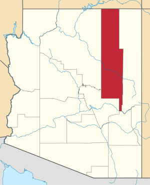
 Location in Navajo County and the state of Arizona | |
 Joseph City, Arizona Location in the United States | |
| Coordinates: 34°57′21″N 110°20′02″W | |
| Country | |
| State | |
| County | Navajo |
| Settled | 1876 |
| Area | |
| • Total | 7.41 sq mi (19.20 km2) |
| • Land | 7.40 sq mi (19.17 km2) |
| • Water | 0.01 sq mi (0.04 km2) |
| Elevation | 5,043 ft (1,537 m) |
| Population (2010) | |
| • Total | 1,386 |
| • Estimate (2016)[3] | N/A |
| Time zone | UTC−7 (MST) |
| • Summer (DST) | UTC−7 (no DST/PDT) |
| ZIP code | 86032 |
| Area code(s) | 928 |
| FIPS code | 04-36430 |
| GNIS ID(s) | 6512, 2582803 |
It is the site of the Jack Rabbit Trading Post, a famous Route 66 landmark.
History
Joseph City was settled in 1876 by colonists who were members of The Church of Jesus Christ of Latter-day Saints. This band of 73 pioneers was led by Captain William C. Allen.[5] They traveled to the Little Colorado River basin of Arizona. Joseph City was one of four Little Colorado River colonies.[6] The other colonies were Brigham City, Sunset, and Obed. Joseph City is the only remaining colony.[7]
The hardest trial for the new colonists was trying to get water for their crops. This meant that they had to try to tame the Little Colorado River. This was difficult due to the flooding season that would destroy dams along the river. The first dam was built in 1876, shortly after the colonists arrived in the area. For the next 18 years the colonists built ten more dams. The eleventh dam was built in 1894. This dam lasted for 29 years. In 1923, the eleventh dam was destroyed and the colonists were forced to build a new dam. This dam still currently stands and directs water to the inhabitants still in the city.[8]
The name of the colony changed twice since its colonization. The area settled by Captain Allen's group was called Allen's Camp, in honor of their leader. There was a name change in January 1878 to St. Joseph. This change was brought about when the Little Colorado Stake was organized. This name was suggested in order to honor Joseph Smith, founder of the Latter Day Saint movement. In 1923 there was a final name change to Joseph City. Due to mail and freight shipment confusions, the Santa Fe Railway, that also ran through Saint Joseph, Missouri, asked that St. Joseph, Arizona change its name. The residents of the town voted and the name became Joseph City.[9]
Geography
Joseph City is located at 34°57′21″N 110°20′02″W (34.955833, -110.333889).[10]
According to the United States Census Bureau, the city has a total area of 7.41 square miles (19.2 km2), of which, 7.4 square miles (19 km2) of it is land and 0.01 square miles (0.026 km2) of it is water.
Climate
Joseph City has a semi-arid climate (BSk) with cold to cool winters and hot summers. Although the mean snowfall is 0.16 metres (6.30 in), the median is zero, so the majority of winters do not have measurable snow.
| Climate data for Joseph City, Arizona | |||||||||||||
|---|---|---|---|---|---|---|---|---|---|---|---|---|---|
| Month | Jan | Feb | Mar | Apr | May | Jun | Jul | Aug | Sep | Oct | Nov | Dec | Year |
| Record high °F (°C) | 74 (23) |
99 (37) |
89 (32) |
93 (34) |
101 (38) |
108 (42) |
106 (41) |
109 (43) |
106 (41) |
96 (36) |
89 (32) |
78 (26) |
109 (43) |
| Average high °F (°C) | 50.6 (10.3) |
57.9 (14.4) |
65.1 (18.4) |
73.3 (22.9) |
81.9 (27.7) |
92.2 (33.4) |
95.4 (35.2) |
92.2 (33.4) |
86.3 (30.2) |
74.7 (23.7) |
61.6 (16.4) |
51.5 (10.8) |
73.6 (23.1) |
| Average low °F (°C) | 20.9 (−6.2) |
25.2 (−3.8) |
30.3 (−0.9) |
35.9 (2.2) |
43.3 (6.3) |
51.4 (10.8) |
59.8 (15.4) |
59.0 (15.0) |
50.9 (10.5) |
38.2 (3.4) |
27.6 (−2.4) |
20.9 (−6.2) |
38.6 (3.7) |
| Record low °F (°C) | −20 (−29) |
−19 (−28) |
2 (−17) |
10 (−12) |
13 (−11) |
30 (−1) |
41 (5) |
36 (2) |
18 (−8) |
15 (−9) |
−10 (−23) |
−21 (−29) |
−21 (−29) |
| Average precipitation inches (mm) | 0.71 (18) |
0.66 (17) |
0.72 (18) |
0.37 (9.4) |
0.38 (9.7) |
0.20 (5.1) |
1.17 (30) |
1.51 (38) |
1.18 (30) |
1.07 (27) |
0.66 (17) |
0.57 (14) |
9.2 (233.2) |
| Average snowfall inches (cm) | 1.5 (3.8) |
1.3 (3.3) |
0.7 (1.8) |
0.8 (2.0) |
0 (0) |
0 (0) |
0 (0) |
0 (0) |
0 (0) |
0 (0) |
1.1 (2.8) |
0.9 (2.3) |
6.3 (16) |
| Average precipitation days (≥ 0.01 inch) | 4.0 | 3.5 | 4.6 | 2.7 | 3.3 | 1.6 | 6.0 | 8.0 | 5.4 | 4.1 | 3.0 | 3.6 | 49.8 |
| Average snowy days (≥ 0.1 inch) | 0.8 | 0.7 | 0.6 | 0.1 | 0 | 0 | 0 | 0 | 0 | 0 | 0.6 | 0.6 | 3.4 |
| Source: [12] | |||||||||||||
Education
Joseph City is served by the Joseph City Unified School District. Two schools, Joseph City Elementary School, and Joseph City High School, serve the community. Their schools have a very high AIMS standard. The current Superintendent of Joseph City Unified School District is Bryan Fields.[13]
Images of Joseph City
Pictured are the following:
- The Historic St. Joseph City Bridge (Obed Bridge) was built in 1912 over the Little Colorado River and located on Obed Road. It was listed in the National Register of Historic Places listed on September 30, 1988, ref.: #88001633,[14]
- Ella's Frontier Store and warehouse located on Main Street between 3rd. Street and O’Connell Lane. The structure was built in 1927 out of telephone poles.[15]
- Historic Marker and ruins on Main Street which indicates where the Mormon Old Fort was once located.[16]
- The Jackrabbit Trading Post was established in 1949 and is located on Route 66.[17]

 1910 house on Main Street
 The St. Joseph Bridge, a.k.a. the Lost Pratt Pony Truss Bridge, built in 1912
 The St. Joseph Bridge
 The St. Joseph Bridge
 Ella's Frontier Trading Post
 Ella's Frontier Trading Post warehouse
 Old Fort marker
 Old Fort ruins and marker
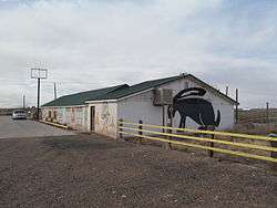 The Jack Rabbit Trading Post
See also
References
- "2016 U.S. Gazetteer Files". United States Census Bureau. Retrieved Jul 18, 2017.
- "Feature Detail Report for: Joseph City". Geographic Names Information System. United States Geological Survey.
- "Population and Housing Unit Estimates". Retrieved June 9, 2017.
- U.S. Census Bureau, Population Finder
- Tanner, George S and J Morris Richards, Colonization on the Little Colorado: The Joseph City Region (Flagstaff, Arizona: 1977) 16.
- Tanner, George S and J Morris Richards, Colonization on the Little Colorado: The Joseph City Region (Flagstaff, Arizona: 1977) xiii.
- Tanner, George S and J Morris Richards, Colonization on the Little Colorado: The Joseph City Region (Flagstaff, Arizona: 1977) 21, 32, 34.
- Tanner, George S and J Morris Richards, Colonization on the Little Colorado: The Joseph City Region (Flagstaff, Arizona: 1977) 41-50.
- Tanner, George S and J Morris Richards, Colonization on the Little Colorado: The Joseph City Region (Flagstaff, Arizona: 1977) 36.
- "US Gazetteer files: 2010, 2000, and 1990". United States Census Bureau. 2011-02-12. Retrieved 2011-04-23.
- "Census of Population and Housing". Census.gov. Retrieved June 4, 2016.
- "HOLBROOK, AZ" (PDF). National Oceanic and Atmospheric Administration. Archived from the original (PDF) on September 10, 2014. Retrieved December 5, 2011.
- "Joseph City: Administration". Archived from the original on 21 February 2014. Retrieved 10 February 2014.
- Briggehunter
- Ella's Frontier Trading Post
- Old Fort
- Route 66