Gila Bend, Arizona
Gila Bend (/ˌhiːlə ˈbɛnd/; O'odham: Hila Wi:n), founded in 1872, is a town in Maricopa County, Arizona, United States. The town is named for an approximately 90-degree bend in the Gila River, which is near the community's current location.[5] According to the 2010 census, the population of the town is 1,922.[3]
Gila Bend, Arizona | |
|---|---|
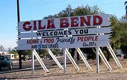 A humorous, numerically outdated sign welcomes people to Gila Bend, Arizona. | |
 Seal | |
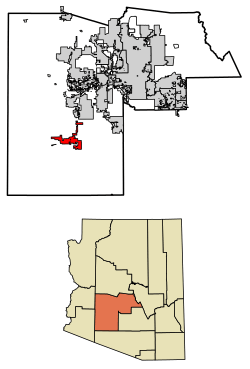 Location of Gila Bend in Maricopa County, Arizona. | |
 Gila Bend, Arizona Location in the United States | |
| Coordinates: 32°56′52″N 112°43′01″W[1] | |
| Country | United States |
| State | Arizona |
| County | Maricopa |
| Founded | 1872 |
| Incorporated | 1962 |
| Government | |
| • Mayor | Tommy Lee Sikes |
| • Town Manager | Michael Celaya |
| Area | |
| • Total | 64.37 sq mi (166.71 km2) |
| • Land | 64.37 sq mi (166.71 km2) |
| • Water | 0.00 sq mi (0.00 km2) |
| Elevation | 735 ft (224 m) |
| Population | |
| • Total | 1,922 |
| • Estimate (2018)[4] | 2,094 |
| • Density | 32.53/sq mi (12.56/km2) |
| Time zone | UTC-7 (MST (no DST)) |
| ZIP code | 85337 |
| Area code(s) | 928 |
| FIPS code | 04-27050 |
| Website | http://www.gilabendaz.org/ |
Just outside the town is the San Lucy district (O'odham: Weco Cekṣanĭ) of the Tohono O'odham Nation, with a small settlement, San Lucy (O'odham: Si:l Mek) bordering the town itself.
History
Oyadaibuc
The town of Gila Bend is situated near an ancient Hohokam village. Father Eusebio Francisco Kino was the first European to visit in 1699 on his first journey of exploration to the Colorado River. The Hohokam site along fertile banks of the Gila River had been abandoned and other tribes, lived in the vicinity. 132 Pima people lived in a rancheria called Oyadaibuc or as Kino named it San Felipe y Santiago del Oyadaibuc, near the modern town, and other Pima lived in three rancherias up river to the north mixed with the Cocomaricopa or Opa. During one of his three visits to Gila Bend, Kino counted 960 Opas living in their own rancherias down river to the west of Oyadaibuc as far as a few miles beyond Agua Caliente.[6]:26–27 The Opa and Pima used the flood waters of the river to irrigate their crops. Oyadaibuc was also visited by Juan Bautista de Anza, commander of the Presidio at Tubac and founder of the city of San Francisco, and by Father Francisco Tomas Garces in 1774.[7] As late as the 1820s Maricopa were living at Gila Bend. After the 1820s, the Maricopa, under relentless pressure from the Yuma and other tribes, and population loss from epidemics, had been compelled to leave the Gila Bend and join the Pima in the Middle Gila region. By the time of the California Gold Rush the Maricopa villages, were all located east of the Sierra Estrella, on the Gila River, below the Pima Villages.[6]:111–112
Tezotal
During the Mexican–American War, the expeditions of Kearny (1846), Cooke (1847) and Graham (1847) passed through the area but found no village. Only Graham found corn stubble on the riverside with which to graze his cattle.[8]:21–22 From 1849 what became the Southern Emigrant Trail passed through the area which by 1854 had acquired the name Tezotal or Tesotal, from name of the scientific name of the desert ironwood tree, (Olneya tesota) given it in the botanical report of the Boundary Survey along the Gila River led by William H. Emory.[9]:117,132
Gila Ranch
From 1857, the place at 33°00′01.87″N 112°41′55.83″W was named Gila Ranch and was a stagecoach water and camping stop on the San Antonio-San Diego Mail Line and in 1858 as Gila Ranch Station, was a stage station on the more famous Butterfield Overland Mail route to California. Gila Bend Station was located 17 miles east of Murderer's Grave Station and 40 miles west of Maricopa Wells Station across the water-less Forty Mile Desert. In 1859, Desert Station was established with its own well on West Prong Waterman Wash, roughly midway across the Forty Mile Desert. Also two tanks were established, one midway between Desert Station and Gila Ranch and the other midway between Desert Station and Maricopa Wells stations, to water the horses. The two riverside stations carried the water to supply these tanks. In 1860 the Gila Ranch station was burnt down, but soon rebuilt.[10]:128–132 In 1861, the Butterfield line shut down but during the American Civil War Gila Ranch remained a stop for freighters to and from the riverport of Arizona City on the Colorado River, passing travelers, the troops of the Confederate Army that briefly passed through and then the California Column of the Union Army that invaded Confederate Arizona and occupied New Mexico Territory in 1862.
Gila Bend
After the Civil War, from 1866 other stage routes were established in Arizona Territory and the Gila Ranch Station again was an active stage station. A settlement, Gila Bend, grew up around it from 1865 and acquired a post office at the station on May 1, 1871.[11]:102 Stage and freight routes, especially from the mining camps and boom towns in central Arizona, converged here especially after the railroad arrived in 1879. In 1880, after wells had been drilled by the railroad near their Gila Bend station, (that was located away from the river), the population began to move to settle at a new town 4 miles south southwest of the old one near the station. Among the first to move being the postmaster at the old stage station, now postmaster of the new town.[12]
The nickname the "Crossroads of the Southwest" stems from the area having been part of an important transportation route in the settling, development and growth of the Southwest. Gila Bend was the "center of a wheel", with spokes leading in many directions.[7]
A more recent event in the area was the October 1995 sabotage of the Amtrak Sunset Limited train.[13]
On December 14, 2006, Volkswagen of America, Inc., leased 11,900 acres (48 km2) of land at a cost of $55 million for 25 years, ten miles (16 km) west of Gila Bend, on which they plan to develop a new automobile proving ground.[14]
Gila Bend enjoys a minor notability among tourists and aficionados of roadside attractions. Besides the quirky welcome sign, the town boasts several roadside sculptures[15] and the Space Age Lodge motel and restaurant (opened in 1963), named for its "Space Age" themed architecture and decor.[16][17]
In 2010 Abengoa Solar secured a $1.45 BUSD loan guarantee to build a large 280 megawatt concentrated solar power Plant in Gila Bend. It was estimated that the project would employ a peak of 1,500 workers with an operational permanent employment of approximately 85 workers.[18] The Solana Generating Station began providing power for Arizona Public Service in 2013.[19]
Geography
The town is just off Interstate 8 on Arizona State Route 85, which provides access between I-8 and Interstate 10 north of Gila Bend. In recognition of historical routes that pass through the area, the town's website refers to Gila Bend as "The Crossroads of the Southwest".[7] According to the United States Census Bureau, the town has a total area of 22.8 square miles (59 km2), all of it land.
Climate
| Climate data for Gila Bend, Arizona | |||||||||||||
|---|---|---|---|---|---|---|---|---|---|---|---|---|---|
| Month | Jan | Feb | Mar | Apr | May | Jun | Jul | Aug | Sep | Oct | Nov | Dec | Year |
| Average high °F (°C) | 69 (21) |
74 (23) |
80 (27) |
88 (31) |
97 (36) |
106 (41) |
109 (43) |
107 (42) |
103 (39) |
91 (33) |
78 (26) |
69 (21) |
89 (32) |
| Average low °F (°C) | 41 (5) |
44 (7) |
48 (9) |
54 (12) |
62 (17) |
71 (22) |
79 (26) |
79 (26) |
72 (22) |
59 (15) |
47 (8) |
41 (5) |
58 (15) |
| Average precipitation inches (mm) | 0.62 (16) |
0.87 (22) |
0.72 (18) |
0.20 (5.1) |
0.15 (3.8) |
0.04 (1.0) |
0.76 (19) |
1.20 (30) |
0.53 (13) |
0.52 (13) |
0.56 (14) |
0.84 (21) |
7.01 (175.9) |
| Source: Weather.com / NWS | |||||||||||||
Gila Bend has an arid desert climate, characterized by extremely hot summers and warm winters. The average annual rainfall is approximately 7 inches (177.8 mm).
During the winter months, daytime highs average about 65 °F to 75 °F (18 °C to 24 °C). As typical with the desert in relatively undeveloped areas, there is nothing to keep the heat continuing after the sun sets, so temperatures rapidly drop after sunset. Sometimes this swing can be larger than 30 degrees. This means that average wintertime night lows are about 40 °F to 50 °F (4 °C to 10 °C), with an occasional night lower than 40 °F (4 °C). The all time lowest recorded temperature in Gila Bend was 10 °F (−12 °C), which occurred on January 13, 1963.
Gila Bend has extremely hot summers with highest temperatures recorded for the state of Arizona, and temperatures at or exceeding 110 °F (41 °C) are the norm for the entirety of summer as well as the beginning of September. Even the month of May experiences some days above 100 °F (38 °C). With an average July high of 109 °F (43 °C), temperatures exceeding 115 °F (46 °C) are common for the area, especially for that particular month. Lows during the summer are generally in the upper 70s and low 80s. The all-time highest recorded temperature in Gila Bend is 122 °F (50 °C), which occurred on June 26, 1990 and again on July 28, 1995.
Demographics
| Historical population | |||
|---|---|---|---|
| Census | Pop. | %± | |
| 1910 | 199 | — | |
| 1920 | 745 | 274.4% | |
| 1930 | 1,275 | 71.1% | |
| 1960 | 1,813 | — | |
| 1970 | 1,795 | −1.0% | |
| 1980 | 1,585 | −11.7% | |
| 1990 | 1,747 | 10.2% | |
| 2000 | 1,980 | 13.3% | |
| 2010 | 1,922 | −2.9% | |
| Est. 2018 | 2,094 | [4] | 8.9% |
| U.S. Decennial Census[20] | |||
As of the census of 2000, there were 1,980 people, 659 households, and 492 families residing in the town. The population density was 86.7 people per square mile (33.5/km²). There were 766 housing units at an average density of 33.5 per square mile (13.0/km²). The racial makeup of the town was 51.31% White, 1.31% Black or African American, 10.25% Native American, 0.35% Asian, 32.42% from other races, and 4.34% from two or more races. 52.63% of the population were Hispanic or Latino of any race.
There were 659 households out of which 42.8% had children under the age of 18 living with them, 52.7% were married couples living together, 14.3% had a female householder with no husband present, and 25.3% were non-families. 22.2% of all households were made up of individuals and 8.6% had someone living alone who was 65 years of age or older. The average household size was 3.00 and the average family size was 3.51.
In the town, the population was spread out with 32.9% under the age of 18, 11.6% from 18 to 24, 27.0% from 25 to 44, 20.1% from 45 to 64, and 8.4% who were 65 years of age or older. The median age was 29 years. For every 100 females, there were 105.4 males. For every 100 females age 18 and over, there were 107.8 males.
The median income for a household in the town was $26,895, and the median income for a family was $30,403. Males had a median income of $25,284 versus $20,588 for females. The per capita income for the town was $10,793. About 22.2% of families and 24.8% of the population were below the poverty line, including 29.3% of those under age 18 and 23.8% of those age 65 or over.
Historic properties
This is a list of some of the remaining historic structures in Gila Bend.
- The Stout Hotel was built in 1927 and is located at 113 East Pima Street. Known as "The Jewel of the Desert" the hotel ceased its operations in the 1980s. The hotel is listed as historical by the Henry C. Trost Historic Organization. The building was listed in the National Register of Historic Places in September 24, 2018, ref. #100002980.
- Gila Bend Overpass - The overpass was built in 1933–34. It is located on the Business Route 8 over the Southern Pacific railroad line. Listed in the National Register of Historic Places in October 15, 1966, reference# 88001607.
- The Gila Bend Steam Locomotive Water Stop - was built in 1900 and is located near Murphy Street.
- Gillespie Dam Highway Bridge - Northwest of Gila Bend. The bridge was built in 1927 over the Gila River and is located on Old Highway 80 north of Gila Bend and south of Arlington between the Buckeye Hills and the Gila Bend Mountains in Maricopa County. The bridge was at the time the longest highway bridge in the state of Arizona. It was listed on the National Register of Historic Places on May 5, 1981, reference #81000136.
- Gillespie Dam - ruins of the Gillespie Dam as viewed from Gila Bend.
- Painted Rock Petroglyph Site - Along Rocky Point Road Northwest of Gila Bend. Listed in the National Register of Historic Places in November 25, 1977, reference# 77000238.
The following are not pictured:
- The Fortaleza – address restricted. It was listed in the National Register of Historic Places June 23, 1969, reference# 69000035.
- Gatlin Site - address restricted. It was listed in the National Register of Historic Places October 15, 1966, reference# 66000183.
Historic structures pictured
The following are images of the historic structures in Gila Bend and its surrounding areas.
 View of the Stout Hotel.
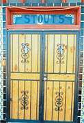 Stout Hotel main door.
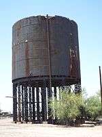 The Gila Bend Steam Locomotive Water Stop was built in 1900 and is located near Murphy Street.
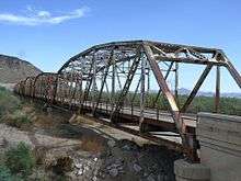 The historic Gillespie Dam Bridge
 Painted Rock Petroglyph Site.
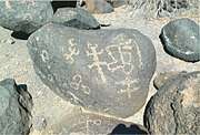 Painted Rock Petroglyph Site.
References
- U.S. Geological Survey Geographic Names Information System: Gila Bend, Arizona
- "2018 U.S. Gazetteer Files". United States Census Bureau. Retrieved July 1, 2019.
- "U.S. Census website". United States Census Bureau. Retrieved July 10, 2014.
- "Population and Housing Unit Estimates". Retrieved June 4, 2019.
- Barnes, Will. "History and Information About Gila Bend, Arizona". reprinted from Arizona's names: X marks the place. Falconer Publishing / Treasure Chest Publications. Archived from the original on May 14, 2006. Retrieved December 6, 2006.
- John P. Wilson, Peoples of the Middle Gila: A Documentary History of the Pimas and Maricopas, 1500s – 1945, Researched and Written for the Gila River Indian Community, Sacaton, Arizona, 1999.
- "Town of Gila Bend – The Crossroads of the Southwest". Town of Gila Bend web site. Town of Gila Bend. Retrieved December 6, 2006.
- PAUL H. EZELL, THE MARICOPAS, An Identification From Documentary Sources, NUMBER 6, ANTHROPOLOGICAL PAPERS OF THE UNIVERSITY OF ARIZONA, THE UNIVERSITY OF ARIZONA PRESS, TUCSON, 1963.
- William H. Emory, Report on the United States and Mexican boundary survey: made under the Direction of the Secretary of the Interior, Volume 1, United States. Dept. of the Interior, A. O. P. Nicholson, Washington, 1857]
- Sanders, Kirby, Butterfield Overland Mail Route Through New Mexico and Arizona, Kirby Sanders and Amazon Createspace, 2013.
- Theobald, John and Lillian, Arizona Territorial Post Offices and Postmasters, Arizona Historical Foundation, Phoenix, 1961.
- Will C. Barnes, Arizona Place Names; University of Arizona Press, Tucson, 1960.
- "At least one dead, 100-plus injured in Amtrak derailment". CNN.com. Cable News Network, Inc. Retrieved December 6, 2006.
- "State Land Department Announces Auction Success With Volkswagen Of America, Inc". State Land Department News & Information. Arizona State Land Department. December 15, 2006. Archived from the original on February 23, 2007. Retrieved January 24, 2007.
- "Gila Bend, Arizona". Roadside America. Retrieved December 6, 2006.
- "Best Western Space Age Lodge and Restaurant". Retrieved February 10, 2009.
- "Gila Bend". Around AZ. Retrieved December 6, 2006.
- Smith, Rebecca (December 30, 2010). "Solar Plant to Generate Power After Sundown" (Webpage). online.wsj.com. Wall Street Journal, Inc. Retrieved January 5, 2011.
- Randazzo, Ryan (June 15, 2015). "Large solar plant fails to reach its energy capacity" (Webpage). azcentral.com. Arizona Republic. Retrieved January 23, 2016.
- "Census of Population and Housing". Census.gov. Retrieved June 4, 2016.
External links
| Wikimedia Commons has media related to Gila Bend, Arizona. |
- Official website
- http://www.time.com/time/magazine/article/0,9171,907001,00.htm Death at Gila Bend
Municipalities and communities of Maricopa County, Arizona, United States | ||
|---|---|---|
| Cities | 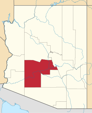 | |
| Towns | ||
| CDPs | ||
| Populated places |
| |
| Indian reservations | ||
| Ghost towns/ former populated places | ||
| Footnotes | ‡This populated place also has portions in an adjacent county or counties | |
| Authority control |
|
|---|