Miyakojima, Okinawa
Miyakojima (宮古島市, Miyakojima-shi, Miyako: Myaaku, Okinawan: Naaku) is a city jurisdiction located on several islands in Okinawa Prefecture, Japan.
Miyakojima 宮古島市 Myaaku | |
|---|---|
     | |
 Flag  Seal | |
 Outline of Miyakojima (in red) in Okinawa Prefecture | |
 Miyakojima Location of Miyakojima in Okinawa Prefecture | |
| Coordinates: 24°48′20″N 125°16′52″E | |
| Country | Japan |
| Region | Kyushu (Okinawa) |
| Prefecture | Okinawa Prefecture |
| Government | |
| • Mayor | Toshihiko Shimoji |
| Area | |
| • Total | 204.54 km2 (78.97 sq mi) |
| Population (December, 2012) | |
| • Total | 54,908 |
| • Density | 268.45/km2 (695.3/sq mi) |
| Time zone | UTC+9 (Japan Standard Time) |
| - Tree | Banyan |
| - Flower | Bougainvillea and tiger's claw |
| - Bird | Grey-faced buzzard |
| - Butterfly | Paper kite |
| - Fish | Double-lined fusilier (Pterocaesio digramma) |
| - Shell | Chiragra spider conch (Lambis chiragra) |
| Phone number | 0980-72-3751 |
| Address | 186 Hirara Nishizato, Miyakojima-shi 906-8501 |
| Website | www |
The modern city of Miyakojima was established on October 1, 2005, from the merger of the old city of Hirara, the towns of Gusukube, Irabu and Shimoji, and the village of Ueno (all from Miyako District). As a result of the merger, Miyako District only has one remaining village.
As of December 2012 the city has an estimated population of 54,908 and a population density of 268.45 per km2. The total area is 204.54 km2. The city had 24,728 households.[1] The mayor of Miyakojima is Toshihiko Shimoji (born 1945), who took office in the second mayoral election of the city in 2009.[2]
The islands administered by the city of Miyakojima include:
- Miyako-jima
- Ikemajima
- Ōgamijima
- Irabujima
- Shimojishima
- Kurimajima
Transportation
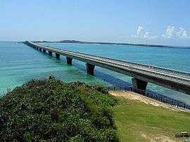
The city of Miyakojima is served by two airports. Miyako Airport (MMY), the main commercial airport, is located on Miyako Island; and Shimoji Airport, initially a private field, is now a Class 3 facility operated by the prefectural government located on Shimojishima. This nearby island is close enough to be connected by a causeway bridge to the larger Miyako Island.
Notable residents
- Arata Tomori, TV personality and doctor
- Erika Sunakawa, singer
- Hideki Irabu, baseball player
- Isamu Shimoji, singer
- Katsuyoshi Tomori, golfer
- Kazumasa Uesato, footballer
- Kenya Tomori, basketball player
- Masanobu Kikukawa, martial artist
- Mikio Shimoji, politician
- Osamu Shimabukuro, basketball player
- Tadashi Kakihana, announcer
Economy
Japan Airlines maintains a ticketing office on Miyakojima island in Miyakojima city. It is only for domestic flights.[3]
German influence
In 1873, the German ship Robertson was shipwrecked on Miyako Island.[4] The crew were saved and cared for by the local islanders. As a gift for the islanders' kindness, and as an excuse for German warships to enter Ryūkyūan waters, Kaiser Wilhelm I erected a monument on the island in 1876, known locally as the German Emperor's Tributary Monument or the Friendship Monument.[4] After Japan annexed the Ryūkyū Kingdom, Japan used this as evidence of a history of friendship between Japan and Germany.[4]
In 1987, the Ueno German Culture Village opened in Ueno village, Miyako.[5] Internet websites under the name Ueno German Cultural Village can be easily found, however Ueno Village, Miyako Island, no longer exists as a jurisdiction since, as mentioned above, all of the separate cities, towns and villages on the island were merged into Miyakojima city in 2005.
Climate
The climate of Miyakojima is on the boundary between a tropical rainforest climate (Köppen climate classification Af) and a humid subtropical climate (Köppen climate classification Cfa) with very warm summers and mild winters. Precipitation is abundant throughout the year; August is the wettest month, and January and July are the driest.
| Climate data for Miyakojima, Okinawa | |||||||||||||
|---|---|---|---|---|---|---|---|---|---|---|---|---|---|
| Month | Jan | Feb | Mar | Apr | May | Jun | Jul | Aug | Sep | Oct | Nov | Dec | Year |
| Average high °C (°F) | 20.4 (68.7) |
20.9 (69.6) |
22.7 (72.9) |
25.1 (77.2) |
27.5 (81.5) |
29.9 (85.8) |
31.6 (88.9) |
31.2 (88.2) |
30.0 (86.0) |
27.8 (82.0) |
25.0 (77.0) |
22.0 (71.6) |
26.2 (79.1) |
| Daily mean °C (°F) | 18.0 (64.4) |
18.3 (64.9) |
20.0 (68.0) |
22.4 (72.3) |
24.8 (76.6) |
27.2 (81.0) |
28.7 (83.7) |
28.5 (83.3) |
27.4 (81.3) |
25.4 (77.7) |
22.7 (72.9) |
19.7 (67.5) |
23.6 (74.5) |
| Average low °C (°F) | 16.0 (60.8) |
16.2 (61.2) |
17.7 (63.9) |
20.2 (68.4) |
22.7 (72.9) |
25.2 (77.4) |
26.6 (79.9) |
26.3 (79.3) |
25.3 (77.5) |
23.6 (74.5) |
20.8 (69.4) |
17.8 (64.0) |
21.5 (70.8) |
| Average precipitation mm (inches) | 130.8 (5.15) |
141.3 (5.56) |
137.8 (5.43) |
160.3 (6.31) |
207.7 (8.18) |
185.5 (7.30) |
130.8 (5.15) |
262.5 (10.33) |
230.0 (9.06) |
156.2 (6.15) |
146.9 (5.78) |
131.3 (5.17) |
2,021.1 (79.57) |
| Average relative humidity (%) | 72 | 75 | 77 | 80 | 82 | 84 | 80 | 80 | 79 | 75 | 73 | 70 | 77 |
| Mean monthly sunshine hours | 86.4 | 82.6 | 112.0 | 123.2 | 151.1 | 191.9 | 246.7 | 220.5 | 184.6 | 153.8 | 112.0 | 101.3 | 1,766.1 |
| Source: JMA (1981-2010) [6] | |||||||||||||
References
- 宮古島市の人口 [Population of Miyakojima City] (in Japanese). Miyakojima City, Okinawa Prefecture, Japan: Miyakojima City. 2012. Retrieved 2012-01-28.
- 市長プロフィール [Profile of Mayor] (in Japanese). Miyakojima City, Okinawa Prefecture, Japan: Miyakojima City. 2012. Retrieved Dec 18, 2012.
- "JAL Group Offices Information." Japan Airlines. Retrieved on July 22, 2011. "MIYAKO Only Domestic Ticketing Available Address 223 Nishizato Hirara Miyako City, 906-0012" Map
- Kerr, George. Okinawa: History of an Island People. Tokyo, Charles E. Tuttle Company, 1958. Page 410.
- http://www.hakuaiueno.com/ 沖縄宮古島の「うえのドイツ文化村」ホームページ
- "Miyakojima Climate Normals 1981-2010" (in Japanese). Japan Meteorological Agency. Retrieved February 16, 2014.
External links
- Miyakojima City official website (in Japanese)
| Wikimedia Commons has media related to Miyakojima, Okinawa. |
| Wikivoyage has a travel guide for Miyako (Okinawa). |
Naha (capital) | ||
| Core city | ||
| Cities |
| |
| Districts | ||
List of mergers in Okinawa Prefecture
| ||
| Authority control |
|
|---|