Isfana
Isfana (Kyrgyz: Исфана; Uzbek: Isfana / Исфана; Russian: Исфана) is a small town in the extreme western end of Batken Region in southern Kyrgyzstan. Isfana is on the southern fringe of the Fergana Valley in a region surrounded on three sides by Tajikistan.
Isfana Исфана | |
|---|---|
Town | |
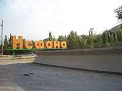 The sign in the northwestern corner of Isfana | |
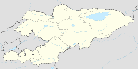 Isfana Location in Kyrgyzstan | |
| Coordinates: 39°50′14″N 69°32′0″E | |
| Country | |
| Region | Batken Region |
| District | Leilek District |
| City status | 2001 |
| Government | |
| • Mayor | Abdivali Khamraev |
| Area | |
| • Town | 2.52 km2 (0.97 sq mi) |
| Elevation | 1,320 m (4,330 ft) |
| Population (2009)[1] | |
| • Town | 27,962 |
| • Density | 11,000/km2 (29,000/sq mi) |
| • Urban | 18,244 |
| Time zone | UTC+6 (KGT) |
| Postal code | 720400[2] |
| Area code(s) | +996 3656 |
| Website | isfanacity.kg |
The word "isfana" is believed to have come from the Sogdian word "asbanikat", "asbanikent" or "aspanakent" which means "the land of horses". Isfana has been inhabited since at least the 9th century. It underwent significant changes during the Soviet period. The selsoviet (rural council) of Isfana was established in 1937. The selsoviet was transformed into a village administration in 1996. In 2001, Askar Akayev issued a presidential decree to make Isfana into a town.
Isfana is the administrative center of Leilek District. The villages Myrza-Patcha, Samat, Chimgen, Taylan, Ak-Bulak, and Golbo are also governed by the Isfana mayor's office. According to data published on the town's official website, the population of Isfana and the subordinated villages is about 28,085. The population of Isfana itself is about 18,200.
History
Toponymy
The word "isfana" is believed to have come from the Sogdian word "asbanikat", "asbanikent" or "aspanakent" which means "the land of horses".[3][4] According to historian Numon Negmatov, from the 1st to the 9th centuries Isfana was known as Asbanikat. From the 10th to the 12th centuries it was called Aspanikent.[5] Starting from the 12th or 13th century the town's name gradually changed to Asbani, Aspana, Asvona, Isvona and, finally, to Isfana.[3]
Since "isfana" is not a Kyrgyz word, Kyrgyz nationalists have lately been calling for renaming the town in honor of Iskhak Razzakov who served as the first secretary of the Communist Party of the Kyrgyz SSR.[6][7]
Early history
The history of Isfana dates back to the 9-16th centuries.[8][9] In 1957, archeologist Y. A. Zadneprovskiy found items dating back to the 14-16th centuries in the territory of the town.[8] According to Numon Negmatov, Isfana corresponds to the medieval town of Asbanikat.[8] The town was first part of Osrushana and was later conquered by the Samanids. In 1221, Isfana was sieged and conquered by the Mongol Empire. The northwestern part of Isfana through which the Mongols invaded is still known as "Moʻgʻul bosgan" which means "conquered by the Mongols".[10]
The medieval town of Isfana was in the central part of modern Isfana. It was home to a large fortress which was built in the 12th century.[3] The last remaining walls of the Isfana Fortress were demolished in the 1970s.[11]
18-19th centuries
Throughout history, Isfana was part of states that reigned the area that more or less corresponds to present-day Uzbekistan. From 1709 until 1876, Isfana was part of the Uzbek Khanate of Kokand. In mid-19th century, the Russian Empire began occupying the area of present-day Central Asia. By the late 19th century, imperial Russia had conquered all of the three states that dominated the territory roughly corresponding to present-day Uzbekistan.[12] The Khanate of Khiva was conquered in 1873 and the Emirate of Bukhara fell in 1868. The Kokand Khanate formally became part of the Russian Empire in 1876.
Russian linguist Mirsalikh Bekchurin wrote that in 1866 there were about 500 households in Isfana.[13] However, Uzbek historian Temirboy Yoqubov disputed this claim, saying that the residents of Isfana had historically paid taxes for 1,000 households.[14] Bekchurin wrote that Isfana was protected by a 200-men garrison whose members were armed "only with lances and sabers".[13]
Soviet and contemporary history
Even though Isfana was historically an Uzbek settlement, it became part of present-day Kyrgyzstan. When Russians split the Turkestan Autonomous Soviet Socialist Republic into autonomous oblasts, Isfana became part of the Kara-Kirghiz Autonomous Oblast, which was later reorganized into the Kirghiz ASSR and later into the Kirghiz SSR. After the dissolution of the USSR, the Kirghiz SSR became Kyrgyzstan. Thus, despite being a majority-Uzbek settlement, Isfana became part of Kyrgyzstan.
Some sources hold that the Soviets drew borders inconsistent with the traditional locations of ethnic populations so that people with historical claims to land would be dependent on the central power, that is Moscow, making them easier to control.[15] According to these sources, the creation of individual republics was meant to reduce the threat of pan-Turkic or pan-Islamic movements in Central Asia.[16] This strategy has been referred to as Joseph Stalin's "divide and rule" policy.[16][15] Currently, there are many traditionally Uzbek settlements in Kyrgyzstan. Many people in Central Asia believe that they should more appropriately be part of another country.[15] However, some scholars claim that since during the Soviet demarcation of Central Asia many places in Central Asia were ethnically mixed, it was impossible to clearly define ethnic and territorial boundaries.[17]
Isfana underwent significant changes during the Soviet period. Under the Soviet rule, Isfana was transformed from an underdeveloped Muslim settlement into a typical Soviet village. The selsoviet (rural council) of Isfana was established in 1937. During World War II, 571 residents of the village were sent to the front line, 385 of whom died fighting.[18]
The Isfana selsoviet was transformed into a village administration in 1996. In 2001, Askar Akayev issued a presidential decree to make Isfana into a town.
Geography
Isfana is in the western part of Batken Region at an altitude of 1,320 meters above sea level. The town is surrounded by mountains on three sides. The mountains are within a few kilometers from the city. The highest of these are the mountains of the Turkestan Range, which is a northern extension of the Pamir-Alay system of mountain ranges.
Area
The area of Isfana is 2.52 square kilometers (0.97 square miles).[9] The total area of Isfana and the villages that are subordinated to the town is 5.88 square kilometers (2.27 square miles).
| Settlement | Area (km2) |
|---|---|
| Isfana | 2.52 |
| Myrza-Patcha | 0.26 |
| Samat | 1.16 |
| Chimgen | 0.87 |
| Taylan | 0.49 |
| Ak-Bulak | 0.3 |
| Golbo | 0.28 |
Climate
Isfana has a cold semi-arid climate (Köppen climate classification BSk) with sharp continental influences. The city has hot summers and cold winters. The spring and fall see significant rainfall, while the summers are hot and dry. There are many dryland wheat and barley fields in the Isfana area that depend on winter snow and spring rain to produce good crops.
Summers are long in Isfana, usually lasting from May to September. Isfana can be extremely hot during the summer months. The town also sees very little precipitation during the summer, particularly from June through September.
| Climate data for Isfana | |||||||||||||
|---|---|---|---|---|---|---|---|---|---|---|---|---|---|
| Month | Jan | Feb | Mar | Apr | May | Jun | Jul | Aug | Sep | Oct | Nov | Dec | Year |
| Average high °C | 4 | 5 | 9 | 17 | 22 | 27 | 29 | 27 | 25 | 17 | 11 | 7 | 17 |
| Average low °C | −4 | −3 | 2 | 8 | 11 | 15 | 17 | 16 | 11 | 6 | 2 | −2 | 7 |
| Average precipitation mm | 24 | 27 | 51 | 45 | 30 | 9 | 3 | 0 | 6 | 18 | 21 | 27 | 261 |
| Average high °F | 39 | 41 | 48 | 63 | 72 | 81 | 84 | 81 | 77 | 63 | 52 | 45 | 62 |
| Average low °F | 25 | 27 | 36 | 46 | 52 | 59 | 63 | 61 | 52 | 43 | 36 | 28 | 44 |
| Average precipitation inches | 0.9 | 1.1 | 2.0 | 1.8 | 1.2 | 0.4 | 0.1 | 0 | 0.2 | 0.7 | 0.8 | 1.1 | 10.3 |
| Source: [19] | |||||||||||||
Demographics
The total population of Isfana and the subordinated villages is estimated to be 28,085 people.[20] The population of the town of Isfana itself is about 18,200.[2] According to the 2009 Population and Housing Census of Kyrgyzstan, at that time the population of Isfana itself was 18,244 and the population of Isfana and the subordinated villages was 27,965.[1] The 1999 census had put the number of people living in the then village of Isfana at 15,910.[1] According to the 2009 Census, the populations of Isfana and the subordinated villages are as follows:
| Settlement | Population |
|---|---|
| Isfana | 18,244 |
| Myrza-Patcha | 770 |
| Samat | 2,076 |
| Chimgen | 3,325 |
| Taylan | 1,360 |
| Ak-Bulak | 681 |
| Golbo | 1,506 |
| Historical population | ||
|---|---|---|
| Year | Pop. | ±% |
| 1979 | 9,629 | — |
| 1989 | 13,193 | +37.0% |
| 1999 | 15,910 | +20.6% |
| 2009 | 18,244 | +14.7% |
| Source: [21][1] | ||
A large number of the residents of Isfana are migrant workers in Russia. There are no official data on the number of Isfanans who work abroad.
Representatives of many ethnic groups can be found in the town. Uzbeks are the largest ethnic group in Isfana. However, if the populations of the six subordinated villages are included, the Kyrgyz become the largest ethnic group. According to data from 2005, the ethnic make-up of Isfana and the six subordinated villages is as follows: 50.2 percent are Kyrgyz, 48.6 percent are Uzbek, 0.3 percent are Tatar, 0.3 percent are Tajik, and the rest are representatives of various other ethnic groups.[9]
Isfana has traditionally been Muslim. The residents of Isfana are Sunni Muslims. There are five mosques in the town. There are no sizeable communities of other religious groups.
Economy
During the Soviet era, there were some factories in Isfana. Also, there was a large kolkhoz. Since Kyrgyzstan became independent in 1991, almost all of the factories have closed.
Many Isfanans now go abroad to make a living, with the most popular destination being Russia. People also go to the neighboring countries of Kazakhstan, Tajikistan, and Uzbekistan. There are no reliable data on the number of labor migrants from Isfana.
People who stay in the town engage in trade and agriculture. Animal husbandry is also widespread. Those who engage in agriculture mostly grow grains, fruits, vegetables, and plants that produce oil.
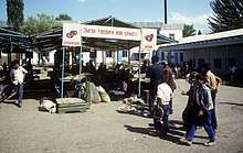
Isfana has two large bazaars. Most sellers who work in these bazaars bring their goods from markets in Osh, Kara-Suu, and Khujand. Isfana also has a livestock market which is open on Thursdays and Fridays.
The economy of Isfana, like the economy of many Kyrgyzstani towns, is primarily kiosk in nature. A large amount of local commerce occurs at the bazaars and small kiosks all over the town. A significant amount of trade is unregulated.
Government
Isfana has a mayor–council form of government. Members of the Town Kenesh (Council) elect the mayor. The Town Kenesh has 30 members. The villages of Myrza-Patcha, Samat, Chimgen, Ak-Bulak, Taylan, and Golbo are also governed by the administration of Isfana. The current mayor of Isfana is Mukhtar Anarbotoyev.[22]
| No. | Mayor | Took office | Left office |
|---|---|---|---|
| 1 | Saliha Muratova | February 2, 2001 | April 10, 2001 |
| 2 | Umarali Isabekov | April 12, 2001 | December 18, 2005 |
| 3 | Maʻrifjon Moʻminov | December 20, 2005 | February 9, 2009 |
| 4 | Ysak Pazylov | March 10, 2009 | July 16, 2010 |
| 5 | Berdimurat Jalilov | July 16, 2010 | August 27, 2011 |
| 6 | Hamza Salyamov | August 27, 2011 | January 31, 2013 |
| 7 | Tashpolot Kozubayev | January 31, 2013 | December 16, 2014 |
| 8 | Mukhtar Anarbotoyev | January 15, 2015 | August 24, 2018 |
| 9 | Abdivali Khamraev | September 18, 2018 | Incumbent |
Isfana is the administrative center of Leilek District to which it is subordinated. All of the administrative agencies of the District of Leilek are in Isfana.
Like in other Kyrgyzstani settlements where there are large groups of ethnic minorities, virtually all administrative positions in Leilek District are held by ethnic Kyrgyz.[23][24] Since Kyrgyzstan became independent, all heads of Leilek District have been ethnic Kyrgyz. Currently there are a few ethnic Uzbeks working in the Isfana Mayor's Office and Isfana Town Council.
Education
High schools

Isfana has many educational institutions. There are two gymnasium schools in Isfana: Gymnasium School No. 1 and the Uzbek Gymnasium. Both of these schools accept more academically-inclined students. There is also a boarding school for children from disadvantaged families, namely Ak Chyiyr Children's Education Center.
There are six secondary schools in Isfana. While in the majority of these schools students are taught only in Uzbek, some schools have both Uzbek and Kyrgyz classes. The largest secondary schools are Alisher Navoiy, Gagarin, and Isfana secondary schools. At Alisher Navoiy Secondary School, classes are taught in Uzbek, Kyrgyz, and Russian. While at Gagarin Secondary School the primary medium of instruction is Russian, the school has Kyrgyz classes as well. At Isfana Secondary School, students are taught only in Uzbek. Amir Temur and Toktogul secondary schools have only Uzbek classes as well. Issyk Kul Secondary School is the smallest school in Isfana and has both Kyrgyz and Uzbek classes.
English is taught as a foreign language at all of the schools in Isfana. However, the quality of English teaching tends to be poor. The students also learn Kyrgyz and Russian, the two official languages of Kyrgyzstan. Thus, in Isfana Uzbek schoolchildren learn four languages and Kyrgyz schoolchildren learn three languages.
Colleges and vocational schools
There is a branch of the International Academy of Management, Law, Finance, and Business (Russian: Международная Академия управления, права, финансов и бизнеса) in Isfana. The academy has its main campus in Bishkek. Isfana is also home to Vocational School No. 48 which trains seamstresses, carpenters, electricians, and drivers.
Culture
There are two libraries in Isfana: a general library and a children's library. Both are public libraries. The general library is in the building of the town recreation center. The general library has 42,515 items, while the children's library has 27,206 items.[9]
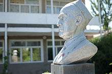
Isfana is home to three museums: the Museum of History (established in 1986), the Iskhak Razzakov Museum (established in 1990), and the Museum of Fame (established in 1990). The town has a children's music school where schoolchildren can learn to sing, dance, and play various musical instruments, such as the accordion, komuz, and piano. Until 2014, there were dayereh, dutar, and rubab classes as well. There is also an educational center for children which offers courses in painting, dancing, sculpture, knitting, computing, and foreign languages.
Isfana has only one park, namely Samat Sadykov Park. There is a soccer stadium in the middle of the park where most public events take place. The stadium can hold up to 5,000 people. The main cinema of Isfana has been closed since Kyrgyzstan gained independence from the Soviet Union in the early 1990s.
There is an Uzbek culture center[9] which has remained largely inactive following the 2010 ethnic clashes between the Kyrgyz and Uzbeks in southern Kyrgyzstan. During the ethnic violence, which lasted from June 10 until June 14, the situation was very volatile in Isfana, but no large clashes took place between members of the two ethnic groups.[25]
Transportation
Isfana is landlocked. The closest railway station is 45 km away in Proletarsk, Tajikistan. The distance between Isfana and Batken, the capital of Batken Region, is 150 km. Isfana is 16 km from the coal mining town of Sulukta.
Land
Public transportation is very poor in Isfana. Public vans (known in Russian as marshrutkas) run through the town. Private taxi cabs can be found along the main roads. Isfana has only one bus station. Buses, minibuses, and taxi cabs run to many parts of Kyrgyzstan from the station.
A very small portion of the roads in Isfana are covered with asphalt. The roads are not well maintained and require major rehabilitation. Isfana is connected with other settlements in Kyrgyzstan through highways. The road that connects Isfana with Batken and Osh was not maintained after Kyrgyzstan became independent in the early 1990s. The country has received funding from the World Bank, the European Bank for Reconstruction and Development, and the Asian Development Bank to rehabilitate the road that connects Isfana with Batken and Osh.[26] The distance from Isfana to the capital Bishkek is 960 km and driving non-stop from Isfana to the capital takes about 20 hours.
Air
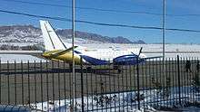
Isfana is served by Isfana Airport built during the Soviet period. Currently it only offers flights to Bishkek. Isfana Airport started its operations in the 1940s as a landing strip near the town. After Kalacha Airport serving Sulukta was closed, Isfana Airport started serving the residents of Sulukta as well. The current runway and terminal of Isfana Airport were built in 1974. In the late 1980s, Isfana Airport stopped its operation because of technical problems. It remained closed for twenty years. In 2007, after the terminal and the track were repaired, the airport was reopened.[27] It was temporarily closed in early 2014, but was re-opened later that year.
Isfana Airport is a regional class 3C airport. The runway has a weight limit of 22 tons and has no instrument landing facilities and operates only during daylight hours. Although Isfana Airport is near the border with Tajikistan, it has no customs and border control checks and serves flights only within Kyrgyzstan.
References
- "2009 Population and Housing Census" (PDF). The National Statistical Committee of the Kyrgyz Republic (in Russian). Bishkek. 2010. Archived from the original (PDF) on 10 August 2011. Retrieved 16 May 2013.
- "Isfana". SPR (in Russian). Archived from the original on 9 June 2016. Retrieved 1 May 2013.
- Yoqubov 2001, p. 9.
- "Интересные факты о городе Исфана" [Interesting facts about Isfana]. Limon (in Russian). 23 January 2015. Retrieved 18 September 2019.
- Yoqubov 2001, p. 20.
- "2015 is going to be the year of Iskhak Razzakov". Ata Jurt (in Kyrgyz) (22 (8418)). 13 December 2014. p. 2.
- "Isfana should be renamed after Iskhak Razzakov". SuLey Info (in Kyrgyz) (107–108). 13 December 2014. p. 2.
- B. Oruzbayeva, ed. (1987). "Isfana". Osh Oblast Encyclopedia (in Russian). Frunze: Kyrgyz Soviet Encyclopedia. p. 247.
- "Isfana: City Profile". The Association of Municipalities of the Kyrgyz Republic. Archived from the original on 24 October 2014. Retrieved 28 April 2013.
- Yoqubov 2001, p. 14.
- Yoqubov 2001, p. 10.
- Fierman, William (2009). "Uzbekistan". Microsoft Student. Redmond, WA: Microsoft Corporation.
- Mir-Salikh Bekchurin (1871). Notes of the Orenburg Department of the Imperial Russian Geographical Society (in Russian). Kazan. p. 228. Retrieved 31 May 2016.
- Yoqubov 2001, p. 31.
- Mayhew, Bradley; Richard Plunkett; Simon Richmond (2000). Lonely Planet Central Asia (2 ed.). Lonely Planet Publications. pp. 34, 159. ISBN 0-86442-673-9.
- William Fierman, ed. (1991). Soviet Central Asia: The Failed Transformation. Boulder: Westview Press. pp. 17. ISBN 0-8133-7907-5.
- Tishkov, Valeriy (1997). Ethnicity, Nationalism and Conflict in and After the Soviet Union: The Mind Aflame. London: Sage Publications. pp. 30–31. ISBN 978-0761951858.
- Yoqubov 2001, p. 51-57.
- "Average high/low temperature for Isfana, Kyrgyzstan". World Weather Online. Retrieved 26 April 2013.
- "About the City". Official website of Isfana (in Russian). Archived from the original on 25 April 2012. Retrieved 19 April 2012.
- "Kyrgyzstan". City Population. Retrieved 30 December 2015.
- Podolskaya, Darya (8 January 2015). "Mukhtar Anarbotoev elected mayor of Isfana". 24kg (in Russian). Retrieved 14 January 2015.
- "Kyrgyzstan: Widening Ethnic Divisions in the South" (PDF). International Crisis Group. Brussels. 29 April 2012. Archived from the original (Report) on 24 November 2013. Retrieved 15 November 2013.
- "Uzbeks of Kyrgyzstan complain of discrimination and corruption". Eurasianet (in Russian). 30 January 2006. Archived from the original on 2012-02-29. Retrieved 29 April 2013.
- Kowalchuk, Darren (29 November 2012). Froese, Ursula (ed.). "Isfana, Kyrgyzstan: Arriving Here from There". OSCE Magazine. Vienna: OSCE (4/2012): 27. Retrieved 13 May 2014.
- Sytenkova, Darya (16 September 2013). "Since becoming independent Kyrgyzstan has received over $1 billion worth of credit to rehabilitate its roads". 24 (in Russian). Archived from the original on 21 September 2013. Retrieved 20 September 2013.
- "Isfana Airport reopened after a twenty-year break in Kyrgyzstan". Centrasia (in Russian). 23 August 2007. Retrieved 20 April 2013.
- Yoqubov, Temirboy (2001). Nurullo Nishonov (ed.). The History of Isfana (Aspanakent) (in Uzbek). Isfana.CS1 maint: ref=harv (link)
External links
| Wikimedia Commons has media related to Isfana. |
- Official website (in Kyrgyz)
- A map of Isfana, MSN
- Profile of Isfana, The Association of Municipalities of the Kyrgyz Republic (in Russian)
- Isfana, Spirit of Salam
- Isfana and Leilek District, SPR (in Russian)
Gallery
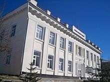
 Leilek District Administration Building
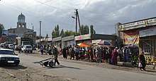
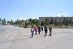
 One of the main streets of Isfana
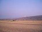 Grain fields in the eastern part of Isfana
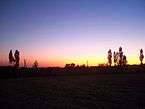 Eastern part of Isfana at dusk
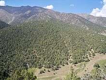
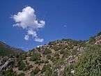 Mountains of the Turkestan Range on the south of Isfana
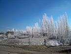 Winter in Isfana