Pamir-Alay
The Pamir-Alay (also Pamiro-Alai, Russian: Памиро-Алай) is a mountain system in Tajikistan, Kyrgyzstan and Uzbekistan, encompassing various mountain ranges extending west from the Tian Shan Mountains, and located north of the main range of Pamir. It stretches between the valleys of the rivers Syr Darya (Fergana Valley) to its north and Vakhsh to its south.[1] Its highest summit is Pik Skalisty (Russian: пик Скалистый, "rocky peak"), 5621 m, in the Turkestan Range.[2]
| Pamir-Alay Памиро-Алай | |
|---|---|
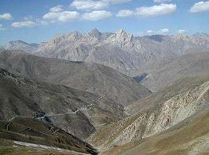 View of the Zarafshan Range near the Anzob Pass | |
| Highest point | |
| Peak | Pik Skalisty |
| Elevation | 5,621 m (18,442 ft) |
| Coordinates | 39°30′N 71°0′E |
| Dimensions | |
| Length | 900 km (560 mi) E/W |
| Width | 400 km (250 mi) N/S |
| Geography | |
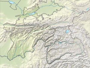 Location in Tajikistan | |
| Country | Tajikistan |
| Parent range | Pamir Mountains |
Main subranges
The Pamir-Alay is subdivided into the following mountain ranges:
- Turkestan Range (5,621 m)
- Alay Mountains (5,544 m)
- Zarafshan Range including Fann Mountains (5,489 m)
- Gissar Range (4,643 m)
- Köýtendag Range (3,139 m)
References
- M. Shahgedanova, The physical geography of northern Eurasia, Oxford University Press, 2003, ISBN 978-0-19-823384-8, chapter 16
- Soviet Union military map 1:500.000 J-42-Б
External links

This article is issued from Wikipedia. The text is licensed under Creative Commons - Attribution - Sharealike. Additional terms may apply for the media files.