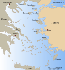
Irakleia (Cyclades)
Irakleia or Heraklia (Greek: Ηρακλειά; Ancient Greek: Ἡράκλεια)[2] is an island and a former community in the Cyclades, Greece. Since the 2011 local government reform it is part of the municipality Naxos and Lesser Cyclades, of which it is a municipal unit.[3] Its population was officially 141 inhabitants at the 2011 census, and its land area 17.795 square kilometres (6.9 sq mi).[4] It is a small island between the islands of Naxos and Ios. Close to Schoinoussa, Koufonisi, Donoussa, and Keros, together they form the Lesser Cyclades. The port is called Agios Georgios, while the "capital"/chora on the top of the island is called Panagia (Madonna). The biggest caves in the Cyclades are located on Irakleia. Irakleia can be reached by ferries from Athens, Naxos and Paros.
Irakleia Ηρακλειά | |
|---|---|
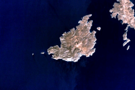 Satellite image of Irakleia. Island at the edge of the image on the right (east) is Schoinoussa, islets on the left (west) are Avelonisia | |
 Irakleia Location within the regional unit 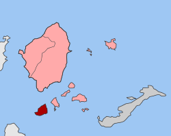 | |
| Coordinates: 36°50′N 25°27′E | |
| Country | Greece |
| Administrative region | South Aegean |
| Regional unit | Naxos |
| Municipality | Naxos and Lesser Cyclades |
| • Municipal unit | 17.795 km2 (6.871 sq mi) |
| Population (2011)[1] | |
| • Municipal unit | 141 |
| • Municipal unit density | 7.9/km2 (21/sq mi) |
| Time zone | UTC+2 (EET) |
| • Summer (DST) | UTC+3 (EEST) |
| Postal code | 843 00 |
| Area code(s) | 22870 |
| Vehicle registration | EM |
| Website | www.iraklia.gr |
Description
Iraklia is the largest island of the Lesser Cyclades. It is located in the east part of the archipelago, which is south of Naxos. The island has two settlements, Panagia in the middle of the island and Agios Georgios, where the port is located. Irakleia has been inhabited from early antiquity. On the island there are many mysterious rock paintings dated about 5,000 years before.[5] The paintings, named Bousoules (Μπούσουλες), may have been used as orientation marks. The ruins of a fortress dating from the 4th-2nd century B.C. are located at Livadi on the island.[6] In modern times, Iraklia was the property of the Hozoviotissa Monastery on the nearby island of Amorgos.[7]
Historical population
| Year | Population |
|---|---|
| 2001 | 151 |
| 2011 | 141 |
References
- "Απογραφή Πληθυσμού - Κατοικιών 2011. ΜΟΝΙΜΟΣ Πληθυσμός" (in Greek). Hellenic Statistical Authority.
- Lund University. Digital Atlas of the Roman Empire.
- Kallikratis law Greece Ministry of Interior (in Greek)
- "Population & housing census 2001 (incl. area and average elevation)" (PDF) (in Greek). National Statistical Service of Greece. Archived from the original (PDF) on 2015-09-21.
- "Σπείρες 5000 ετών από την Ηρακλειά Κυκλάδων". tovima.gr. Retrieved 4 July 2015.
- "Ηρακλειά". egeonet.gr. Archived from the original on 2 July 2013. Retrieved 4 July 2015.
- "Που απλώνεται η ακίνητη περιουσία της Ι.Μ. Χοζοβιώτισσας". cycladesvoice.gr. Retrieved 4 July 2015.
External links
- Official website (in English and Greek)
| Authority control |
|
|---|