Lesser Cyclades
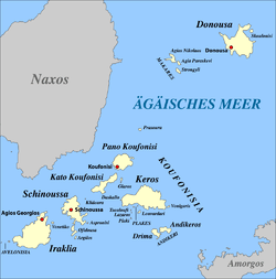
The Lesser Cyclades or Small Cyclades (Greek: Μικρές Κυκλάδες) is an island complex in Aegean Sea, inside the archipelago of the Cyclades. It is located to the south-east of Naxos and comprises 32 islands and rocks.[1] The main islands are Ano Koufonisi, Kato Koufonisi, Irakleia, Schoinoussa, Donousa and Keros. The largest of them is Irakleia with an area of 18 km2 and the most populated is Ano Koufonisi with a population of 399, according to the 2011 census. Only four of them are inhabited, Ano Koufonisi, Irakleia, Donousa and Schoinoussa. The islet of Kato Antikeri has also two inhabitants. Administratively, the islands belong to the Naxos and Lesser Cyclades municipality apart from the islets of Ano and Kato Antikeri that belong to Amorgos municipality.
 Small Cyclades | |
| Geography | |
|---|---|
| Coordinates | 36.86°N 25.71°E |
| Total islands | 32 |
| Administration | |
Greece | |
| Region | South Aegean |
| Regional unit | Naxos |
| Demographics | |
| Population | 965 (2011) |
History
During the last Ice Age most of the islands of the Cyclades were united into a big landmass. After the sea level rose in ca. 9,000 B.C. the Aegean flooded the landmass to form the many small islands and acquire its modern form.[2] The Lesser Cyclades have been inhabited since the Stone Age. The islands flourished during the early Bronze Age, when the Cycladic culture appeared. The island of Keros was one of the major sites of Cycladic culture and has given its name to Early Cycladic II period of Cycladic culture, known as Keros-Syros culture.[3] The islands continued to be populated thereafter. On the islands, mainly Schoinoussa and Irakleia there are ruins from classical antiquity and the Roman period. In medieval and modern times the islands suffered from piracy. Therefore, sometimes the islands were depopulated and were colonised again by shepherds from Amorgos. Since the 11th century most of the islands of the Lesser Cyclades were given as property to the Hozoviotissa Monastery in Amorgos.[4] The monastery even today retains large areas in the islands as ts property.[5] The islands today have been developed as popular tourist destination. They are famous for their serene and tranquil life.
Main islands
| Island | Area (Km2) | Population (2011) |
|---|---|---|
| Irakleia | ||
| Keros | ||
| Donousa | ||
| Schoinoussa | ||
| Ano Koufonisi | ||
| Kato Koufonisi | ||
| Ano Antikeri | ||
| Kato Antikeri |
References
- "Μικροί παράδεισοι στην καρδιά των Κυκλάδων". imerisia.gr. Retrieved 4 July 2015.
- "Geomorphology". ime.gr. Retrieved 4 July 2015.
- "The Bronze Age". fhw.gr. Retrieved 4 July 2015.
- "History Culture". smallcyclades.com. Retrieved 4 July 2015.
- "Που απλώνεται η ακίνητη περιουσία της Ι.Μ. Χοζοβιώτισσας". cycladesvoice.gr. Retrieved 4 July 2015.