Interstate 69E
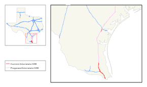
Interstate 69E (I-69E) is a north-south freeway running through South Texas. Once complete the freeway will begin in Brownsville and head northward before terminating near Victoria as both I-69W and I-69E intersect into Interstate 69 toward Houston. For its entire length, I-69E shares its alignment with US 77.
| |
|---|---|
 | |
| Route information | |
| Auxiliary route of I-69 | |
| Maintained by TxDOT | |
| Existed | December 5, 2011 (as I-69)–present |
| East Rio Grande Valley segment | |
| Length | 51.294 mi[1][2] (82.550 km) |
| South end | |
| Major junctions | |
| North end | |
| Corpus Christi area segment | |
| Length | 7.672 mi (12.347 km) |
| South end | |
| North end | |
| Location | |
| Counties | Cameron, Willacy; Nueces |
| Highway system | |
.svg.png)
History
A stated goal of Texas Department of Transportation's (TxDOT) I-69 initiative is that "existing suitable freeway sections of the proposed system be designated as I-69 as soon as possible."[3] A bill was introduced and passed by the House of Representatives that allows interstate quality sections of US 59, US 77, and US 281 to be signed as I-69 regardless of whether or not they connected to other interstate highways.
Texas Department of Transportation submitted an application to the Federal Highway Administration (FHWA) and the American Association of State Highway and Transportation Officials (AASHTO) to designate 75 miles of US 59 in the Houston area and 8 miles of US 77 near Corpus Christi as I-69, as these sections are already built to interstate standards and connect to other interstate highways. In August 2011, TxDOT received approval from FHWA for a six-mile segment of US 77 between I-37 and SH 44 near Corpus Christi, and was approved by the AASHTO in October 2011.[4] Officials held a ceremony on December 5, 2011 to unveil I-69 signs on the Robstown-Corpus Christi section.[5]
The Federal Highway Administration approved the designation for the East Rio Grande Valley Segment on May 24, 2013,[6] and the Texas Transportation Commission followed suit on May 30, 2013.[7] This action finalized the designations of not only I-69E, but also of the sections of I-69C from Pharr north to the end of the US 281 freeway facility near Edinburg, and also Interstate 2 (I-2), which is a 46.8-mile (75.3 km) freeway that runs from Penitas to Harlingen and connects with I-69C and I-69E.[6] These approvals added over 100 miles (160 km) to the Interstate Highway System in the Rio Grande Valley.[8] The signage was installed in summer 2013.[9]
As of June 2013, the cluster consisting of the recently designated portions of I-69E, I-69C, and I-2 in the Rio Grande Valley is not connected to the national Interstate network. This situation is slated to be remedied by scheduled projects to complete I-69E along US 77 between Raymondville and Robstown, and to complete the southern end of the previously signed portion of the I-69 corridor connecting with I-37 west of Corpus Christi. Environmental Protection Agency approval for the upgrade of the US 77 alignment to Interstate standards, including bypasses of the towns along the 91-mile (146 km) routing, was obtained through a Finding of No Significant Impact statement issued on July 13, 2012;[10] funding for the various projects to effect the upgrades is slated to become available after 2015.[11] During its 2019 Annual Meeting in October 2019, AASHTO approved an extension of the I-69E designation along US-77 from FM 892 to FM 2826 in Nueces County. The 3.3 mile extension completes I-69E from I-37 in Calallen to the north end of the Driscoll Bypass that is currently under construction.
Exit list
| County | Location | mi[2] | km | Exit[12] | Destinations | Notes | |
|---|---|---|---|---|---|---|---|
| Cameron | Brownsville | 0.000 | 0.000 | To Veterans International Bridge | Bridge over the Río Grande to Mexico; south end of US 77/US 83 concurrency | ||
| Brownsville Veterans Port of Entry | |||||||
| 0.210 | 0.338 | University Boulevard / East Avenue | Traffic controlled level intersection | ||||
| Southern end of the freeway | |||||||
| 0.321 | 0.517 | 0 | Polk Street | Southbound exit only | |||
| 0.607– 1.491 | 0.977– 2.400 | 1A | |||||
| 1.727– 1.780 | 2.779– 2.865 | 1B | 12th Street / 14th Street | Southbound exit and northbound entrance | |||
| 2.322 | 3.737 | 1C | 6th Street | Southbound exit and northbound entrance | |||
| 1.989– 3.328 | 3.201– 5.356 | 2 | |||||
| 2.594– 4.440 | 4.175– 7.145 | 3 | Price Road / Old Alice Road | ||||
| 3.597– 5.702 | 5.789– 9.176 | 4 | To Brownsville Baptist Medical Center | ||||
| 4.450– 6.472 | 7.162– 10.416 | 5 | Pablo Kisel Boulevard / Morrison Road | ||||
| 5.854– 7.022 | 9.421– 11.301 | 6 | To Valley Regional Medical Center | ||||
| 7.193– 7.913 | 11.576– 12.735 | 7 | Stillman Road / Old Alice Road | ||||
| 8.233– 8.988 | 13.250– 14.465 | 8 | Merryman Road | ||||
| 9.083– 9.843 | 14.618– 15.841 | 9 | |||||
| 9.962– 11.032 | 16.032– 17.754 | 10A | |||||
| 10.725– 10.857 | 17.260– 17.473 | 10B | Southbound exit and northbound entrance | ||||
| 11.177– 12.304 | 17.988– 19.801 | 11 | |||||
| 12.502– 13.356 | 20.120– 21.494 | 12 | Carmen Avenue | ||||
| 13.525– 14.273 | 21.766– 22.970 | 13 | Roberta Road | ||||
| 14.629– 15.395 | 23.543– 24.776 | 14 | |||||
| 15.761– 17.254 | 25.365– 27.768 | 16 | Frontage Road | ||||
| 16.400– 17.254 | 26.393– 27.768 | Parking Area | |||||
| | 16.400– 17.151 | 26.393– 27.602 | 17 | Northbound exit and southbound entrance | |||
| San Benito | 17.953– 18.748 | 28.893– 30.172 | 18 | ||||
| 18.964– 20.708 | 30.520– 33.326 | 19A | McCulloch Street | No direct southbound exit (signed at exit 19B) | |||
| 19.532– 20.512 | 31.434– 33.011 | 19B | Ratliff Street signed at exit 21 southbound | ||||
| 20.512– 21.844 | 33.011– 35.155 | 21 | |||||
| 21.973– 22.724 | 35.362– 36.571 | 22 | |||||
| Harlingen | 22.887– 23.903 | 36.833– 38.468 | 23A | To Valley Baptist Medical Center | |||
| 24.194– 24.805 | 38.936– 39.920 | 23B | New Hampshire Street | No direct northbound exit (signed at exit 23A) | |||
| 24.191– 25.732 | 38.932– 41.412 | 24 | |||||
| 25.202 | 40.559 | 25 | M Street | Northbound exit and southbound entrance | |||
| 25.756– 25.791 | 41.450– 41.507 | 26A | Lincoln Avenue | Northbound exit and southbound entrance | |||
| 26.178– 27.277 | 42.129– 43.898 | 26B | Eastern terminus of westbound Bus. US 83; north end of US 83 overlap; south end of northbound Bus. US 83 overlap; I-2 exit 176; eastern terminus of I-2 | ||||
| 26.348– 26.975 | 42.403– 43.412 | 26C | Eastern terminus of eastbound Bus. US 83; north end of northbound Bus. US 83 concurrency; Bus. US 83 not signed southbound | ||||
| 27.441– 27.636 | 44.162– 44.476 | 27 | No direct northbound exit (signed at exit 26C) | ||||
| 27.754– 28.709 | 44.666– 46.203 | 28 | |||||
| Harlingen–Combes line | 28.981– 29.826 | 46.640– 48.000 | 29A | Signed as exit 29 southbound | |||
| 29.562 | 47.575 | 29B | Northbound exit only | ||||
| Combes | 30.392– 31.187 | 48.911– 50.191 | 30 | ||||
| | 32.337– 33.165 | 52.041– 53.374 | 32 | ||||
| | 34.447– 35.224 | 55.437– 56.688 | 34 | Orphanage Road / V Road | |||
| | 36.732– 37.689 | 59.114– 60.655 | 36 | ||||
| Willacy | Sebastian | 38.033– 38.785 | 61.208– 62.418 | 38 | |||
| 39.007– 39.853 | 62.776– 64.137 | 39 | |||||
| | 41.864 | 67.374 | 42A | No direct southbound exit (signed at exit 42B) | |||
| Lyford | 42.556– 43.589 | 68.487– 70.150 | 42B | ||||
| | 44.150– 45.251 | 71.053– 72.824 | 44 | ||||
| | 45.617– 46.385 | 73.413– 74.649 | 45 | ||||
| Raymondville | 46.729– 47.584 | 75.203– 76.579 | 47 | ||||
| 47.793– 48.654 | 76.915– 78.301 | 48 | |||||
| | 49.324 | 79.379 | 49 | No direct northbound exit (signed at exit 51) | |||
| | 51.011 517.711 | 82.094 833.175 | 51 | Mileposts at northern end of the exit reflect US 77 | |||
| Gap in route, connection made via US 77 | |||||||
| Nueces | La Paloma-Lost Creek | 430.8 | 693.3 | — | |||
| Robstown | 428.606 141.578 | 689.774 227.848 | — | County Road 36 | Southbound exit and northbound entrance; mileposts at the southern end of the exit reflect US 77 | ||
| 142.693 | 229.642 | — | Southbound exit and northbound entrance | ||||
| 142.097– 143.986 | 228.683– 231.723 | — | Split into east and west exits northbound | ||||
| 144.643 | 232.780 | — | County Road 44 | Northbound exit and southbound entrance | |||
| | 146.729– 147.360 | 236.137– 237.153 | — | ||||
| Corpus Christi | 147.939 | 238.085 | — | County Road 52 | No direct northbound exit (signed at FM 624) | ||
| 148.429– 148.532 | 238.873– 239.039 | — | To Corpus Christi Medical Center-Northwest; southbound exit and northbound entrance only | ||||
| 148.663– 148.811 | 239.250– 239.488 | — | Exit 14A on I-37 north | ||||
| 149.253 | 240.199 | — | Sharpsburg Road | Northbound exit only | |||
| 149.387 | 240.415 | Continues north as I-37/US 77; exit 14 on I-37 south | |||||
1.000 mi = 1.609 km; 1.000 km = 0.621 mi
| |||||||
See also


References
- Transportation Planning and Programming Division (n.d.). "Interstate Highway No. 69-E". Highway Designation Files. Texas Department of Transportation. Retrieved September 3, 2013.
- Texas Department of Transportation (2018). "Statewide Planning Map LRS Readout (ArcGIS)". Retrieved October 4, 2019.
- "What's Next for I-69 Texas?". Texas Department of Transportation. Retrieved August 2011. Check date values in:
|accessdate=(help) - "Portion of US 77 Approved as Part of U.S. Interstate System" (Press release). Texas Department of Transportation. Archived from the original on November 2, 2011. Retrieved July 17, 2013.
- Clark, Steve (October 30, 2011). "First I-69 signs going up on U.S. 77 in December". Brownsville Herald. Retrieved July 17, 2013.
- Staff (May 30, 2013). "Interstate 69 Comes to Texarkana and the Valley" (Press release). Alliance for I-69 Texas. Retrieved July 17, 2013.
- Nino, Mark (May 31, 2013). "Texas Transportation Commission Approves Interstate 69 System". Brownsville, TX: KVEO-TV. Retrieved July 17, 2013.
- Taylor, Steve (May 30, 2013). "Over 100 Miles of Valley Highways To Be Designated Interstate". Rio Grande Guardian. McAllen, TX. Archived from the original on October 18, 2013. Retrieved July 17, 2013.
- Janes, Jared (July 15, 2013). "Valley's I-69 signage the latest stop along superhighway dream". The Monitor. Retrieved July 17, 2013.
- Staff (July 13, 2012). "Agency Gives US 77 Upgrades Final Environmental Clearance" (Press release). Alliance for I-69 Texas. Retrieved July 17, 2013.
- Clark, Steve (August 8, 2011). "Interstate Link to Valley Moves Closer to Reality, Official Says". Brownsville Herald. Retrieved July 17, 2013.
- Texas Department of Transportation, plans of proposed highway maintenance contract (1.58 GB ZIP file), December 2014