Interstate 69C
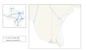
Interstate 69C (I-69C) is a north-south freeway running through South Texas. Once complete, the freeway (with connections to Mexican Federal Highway 97) will begin at Interstate 2/U.S. Highway 83 in Pharr and head northward before terminating at I-69W/US 59 in George West near I-37. For its entire length, I-69C shares its alignment with US 281.
| |
|---|---|
 | |
| Route information | |
| Auxiliary route of I-69 | |
| Maintained by TxDOT | |
| Length | 18 mi[1] (29 km) |
| Existed | May 30, 2013–present |
| Major junctions | |
| South end | |
| North end | |
| Location | |
| Counties | Hidalgo |
| Highway system | |
.svg.png)
History

The Federal Highway Administration approved the designation for the South Rio Grande Valley Segment on May 24, 2013,[2] and the Texas Transportation Commission followed suit on May 30, 2013.[3] This action finalized the designations of not only I-69C, but also of the sections of Interstate 69E (I-69E) from Brownsville north to north of Raymondville, and also Interstate 2 (I-2) which is a 46.8-mile (75.3 km) freeway connecting with I-69C and I-69E in Pharr and Harlingen.[2] These approvals added over 100 miles (160 km) to the Interstate Highway System in the Rio Grande Valley.[4] The signage was installed in summer 2013.[5]
As of April 2020, the cluster consisting of the recently designated portions of I-69C, I-69E, and I-2 in the Rio Grande Valley is not connected to the national Interstate network. This situation is slated to be remedied by scheduled projects to complete I-69E along US 77 between Raymondville and Robstown, and to complete the southern end of the previously signed portion of the I-69 corridor connecting with I-37 west of Corpus Christi. Environmental Protection Agency approval for the upgrade of the US 77 alignment to Interstate standards, including bypasses of the towns along the 91-mile (146 km) routing, was obtained through a Finding of No Significant Impact statement issued on July 13, 2012;[6] funding for the various upgrade projects is slated to become available after 2015.[7] During August 2014, exit numbering began on the south most segment in Edinburg.
Exit list
The entire route is in Hidalgo County.
| Location | mi | km | Exit[8] | Destinations | Notes | |
|---|---|---|---|---|---|---|
| Pharr | 0.00 | 0.00 | 1A-B | Signed as exits 1A (west) and 1B (east); exits 146A-B on I-2 | ||
| 0.35 | 0.56 | 1C | South end of US 281 overlap; southbound exit and northbound entrance | |||
| 0.85 | 1.37 | 1D | Sioux Road | Southbound exit and northbound entrance | ||
| 1.85 | 2.98 | 1E | ||||
| Pharr–Edinburg line | 2.99 | 4.81 | 2 | To Doctors Hospital at Renaissance | ||
| Edinburg | 4.00 | 6.44 | 3 | To Cornerstone Regional Hospital, Edinburg Regional Medical Center | ||
| 5.15 | 8.29 | 4 | Canton Road / Veterans Boulevard | |||
| 5.93 | 9.54 | 5 | Freddy Gonzalez Drive / Sprague Street | |||
| 6.95 | 11.18 | 6 | ||||
| 7.44 | 11.97 | 7 | ||||
| 8.98 | 14.45 | 8 | Russell Road / Rogers Road | |||
| 9.48 | 15.26 | 9 | ||||
| 10.09 | 16.24 | 10 | Southbound exit and northbound entrance | |||
| 11.04– 11.61 | 17.77– 18.68 | 11 | Davis Drive / Ramseyer Road | |||
| 12.98 | 20.89 | 12 | ||||
| – | Faysville | |||||
| 15.16 | 24.40 | – | ||||
| 17.56 | 28.26 | – | To South Texas International Airport at Edinburg; continues north as US 281 | |||
1.000 mi = 1.609 km; 1.000 km = 0.621 mi
| ||||||
See also


References
- Transportation Planning and Programming Division (n.d.). "Interstate Highway No. 69-C". Highway Designation Files. Texas Department of Transportation. Retrieved September 3, 2013.
- Staff (May 30, 2013). "Interstate 69 Comes to Texarkana and the Valley" (Press release). Alliance for I-69 Texas. Retrieved July 17, 2013.
- Nino, Mark (May 31, 2013). "Texas Transportation Commission Approves Interstate 69 System". Brownsville, TX: KVEO-TV. Retrieved July 17, 2013.
- Taylor, Steve (May 30, 2013). "Over 100 Miles of Valley Highways To Be Designated Interstate". Rio Grande Guardian. McAllen, TX. Archived from the original on October 18, 2013. Retrieved July 17, 2013.
- Janes, Jared (July 15, 2013). "Valley's I-69 signage the latest stop along superhighway dream". The Monitor. Retrieved July 17, 2013.
- Staff (July 13, 2012). "Agency Gives US 77 Upgrades Final Environmental Clearance" (Press release). Alliance for I-69 Texas. Retrieved July 17, 2013.
- Clark, Steve (August 8, 2011). "Interstate Link to Valley Moves Closer to Reality, Official Says". Brownsville Herald. Retrieved July 17, 2013.
- Texas Department of Transportation, plans of proposed highway maintenance contract (1.58 GB ZIP file), December 2014
External links
