Indre Fosen
Indre Fosen is a municipality in Trøndelag county, Norway. It is located in the traditional district of Fosen. The administrative centre of the municipality is the village of Årnset. Other villages in Indre Fosen include Askjem, Dalbygda, Hasselvika, Husbysjøen, Leira, Leksvik, Råkvåg, Rørvika, Seter, Stadsbygd, Verrabotn, and Vanvikan. The Norwegian County Road 755 runs through the municipality.
Indre Fosen kommune | |
|---|---|
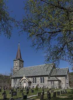 View of the Rissa Church | |
 Coat of arms 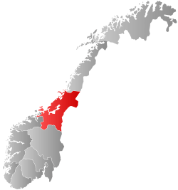 Trøndelag within Norway | |
 Indre Fosen within Trøndelag | |
| Coordinates: 63.64382°N 10.18707°E | |
| Country | Norway |
| County | Trøndelag |
| District | Fosen |
| Established | 1 Jan 2018 |
| Administrative centre | Årnset |
| Government | |
| • Mayor (2019) | Bjørnar Buhaug (Sp) |
| Area | |
| • Total | 1,095.98 km2 (423.16 sq mi) |
| • Land | 1,030.41 km2 (397.84 sq mi) |
| • Water | 65.57 km2 (25.32 sq mi) 6% |
| Area rank | 102 in Norway |
| Population (2020) | |
| • Total | 10,084 |
| • Rank | 113 in Norway |
| • Density | 9.8/km2 (25/sq mi) |
| • Change (10 years) | 1.1% |
| Demonym(s) | fosning rissværing leksværing[1] |
| Time zone | UTC+01:00 (CET) |
| • Summer (DST) | UTC+02:00 (CEST) |
| ISO 3166 code | NO-5054 |
| Official language form | Neutral[2] |
| Website | indrefosen |
The 1,096-square-kilometre (423 sq mi) municipality is the 102nd largest by area out of the 356 municipalities in Norway. Indre Fosen is the 113th most populous municipality in Norway with a population of 10,084. The municipality's population density is 9.8 inhabitants per square kilometre (25/sq mi) and its population has increased by 1.1% over the previous 10-year period.[3][4]
General information
The municipality was established on 1 January 2018, the same day that Trøndelag county was established. Indre Fosen straddles the former county border, as it was formed by the unification of the neighboring municipalities of Leksvik (formerly in Nord-Trøndelag) and Rissa (formerly in Sør-Trøndelag).[5]
On 1 January 2020, the Verrabotn area of neighboring Verran Municipality was transferred to Indre Fosen.[6]
Name
The municipality was named after the traditional district of Fosen in which it is located. The district is named after the island of Storfosna ("Big Fosen") in Ørland municipality. The Old Norse form of the name was Fólgsn which means "hiding place" or "hidden port".[7] The first word Indre means "inner" in the Norwegian language, here meaning the inner part of the district of Fosen.
Coat of arms
The coat of arms of Indre Fosen are fairly modern; they were originally granted to the old Leksvik Municipality on 28 September 1990. When the new municipality was formed, it was decided to keep the arms of Leksvik for the new municipality, so they were re-granted to Indre Fosen in 2016 to take effect on 1 January 2018.[5] The arms are blue and silver. The blue part represents the Trondheimsfjord and the silver part represents the land. There is a clover design at the end of the silver part which represents life and growth.[8]
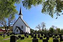
Churches
The Church of Norway has six parishes (Norwegian: sogn, which is both singular and plural) within the municipality. Together with the other municipalities on the Fosen peninsula (Bjugn, Osen, Roan, Ørland, and Åfjord), Indre Fosen is part of the Fosen prosti (deanery) in the Diocese of Nidaros.
| Parish (sokn) | Church Name | Location of the Church | Year Built |
|---|---|---|---|
| Hasselvika | Hasselvika Church | Hasselvika | 1951 |
| Leksvik | Leksvik Church | Leksvik | 1670 |
| Rissa | Fines Church | Verrabotn | 1913 |
| Rissa Church | Leira | 1888 | |
| Rein Church | Reinsgrenda | 1932 | |
| Stadsbygd | Stadsbygd Church | Stadsbygd | 1842 |
| Stranda | Stranda Church | Vanvikan | 1897 |
| Sør-Stjørna | Frengen Church | Frengen | 1972 |
| Ramsvik Church | Råkvåg | 1909 |
History
The first inhabitants are believed to have moved to this area some 3,000 years ago. They left several pieces of cutting tools which are now placed in museums. The Leksvik area does not appear in recorded history before the Viking Age when the villages of Leksvik and Hindrem became quite important in the local area. In both Leksvik and Hindrem there have been found great tombs and ruins of buildings and longboats. On Borgen, there is a hill between Hindrem and Seter that may have been a great Viking fortress, but this could also be tracks made by the glaciers during the last ice age. After the Black Death struck Norway in 1349, Leksvik fell into silence for some 300 years.
In more modern history, Leksvik and Hindrem are small and relatively isolated villages, north of Trondheimsfjord. Two churches stood here, a church in Leksvik and a stave church in Hindrem, but this broke down in 1655 and was replaced by a modern wooden church. In the 19th century, the church of Hindrem was demolished, and the new Stranda Church was built in Vanvikan. Leksvik became well known for its goats and had 5,000 of them at their peak number.
During World War II, Leksvik was settled by German troops with the main camp on the top of Våttåhaugen, a hill north of the village of Leksvik. But as a small and isolated village, nothing of great importance happened there during the war, and it was mostly peaceful although bombs fell over Trondheim, on the south side of the fjord. After electric power first came to Leksvik, Bjørn Lyng founded the first industry in Vanvikan and Leksvik. After the first road was finally finished in the early 1960s, industry grew rapidly and replaced the goats.
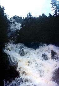
In April 1978, the Rissa area in what is now Indre Fosen was home to a quick-clay landslide which encompassed an area of 330,000 square metres (3,600,000 sq ft) and sent 6,000,000 cubic metres (7,800,000 cu yd) of clay from the Årnset area on the shore into the Botn lake, causing a miniature tsunami on the north shore in the village of Leira. This slide is particularly famous because a large portion of the slide happened to be recorded on film by two amateur photographers.
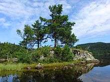
Geography
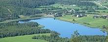
Indre Fosen was located on the southern part of the Fosen peninsula along the coast of Trondheimsfjorden and the Stjørnfjorden, surrounding the municipality on three sides by water. There are several large lakes located in Indre Fosen including Storvatnet, Meltingvatnet, and Botn. The municipalities of Åfjord, Verran, and Inderøy lie to the north and the municipalities of Bjugn and Ørland lie to the west.
The Flakk–Rørvik Ferry crosses the Trondheimsfjord connecting the village of Rørvik to the city of Trondheim to the south.
Government
All municipalities in Norway, including Indre Fosen, are responsible for primary education (kindergarten through 10th grade), outpatient health services, senior citizen services, unemployment and other social services, zoning, economic development, and municipal roads. The municipality is governed by a municipal council of elected representatives, which in turn elects a mayor.[9]
For the purposes of judicial divisions, the municipality is part of the Fosen District Court which is under the Frostating Court of Appeal.
Municipal council
The municipal council (Kommunestyre) of Indre Fosen is made up of 37 representatives. The party breakdown of the council is as follows:
| Party Name (in Norwegian) | Number of representatives | |
|---|---|---|
| Labour Party (Arbeiderpartiet) | 6 | |
| Progress Party (Fremskrittspartiet) | 2 | |
| Green Party (Miljøpartiet De Grønne) | 1 | |
| Conservative Party (Høyre) | 5 | |
| Christian Democratic Party (Kristelig Folkeparti) | 1 | |
| Pensioners' Party (Pensjonistpartiet) | 4 | |
| Centre Party (Senterpartiet) | 10 | |
| Socialist Left Party (Sosialistisk Venstreparti) | 2 | |
| Municipal List (Kommunelista) | 6 | |
| Total number of members: | 37 | |
| Party Name (in Norwegian) | Number of representatives | |
|---|---|---|
| Labour Party (Arbeiderpartiet) | 15 | |
| Progress Party (Fremskrittspartiet) | 3 | |
| Green Party (Miljøpartiet De Grønne) | 1 | |
| Conservative Party (Høyre) | 12 | |
| Christian Democratic Party (Kristelig Folkeparti) | 2 | |
| Pensioners' Party (Pensjonistpartiet) | 2 | |
| Centre Party (Senterpartiet) | 9 | |
| Socialist Left Party (Sosialistisk Venstreparti) | 2 | |
| Liberal Party (Venstre) | 2 | |
| Total number of members: | 48 | |
| Note: Rather than have new elections when the municipality and its council were originally formed in 2018, members were carried over onto the new council. The council is essentially a merger of the old municipal councils of Leksvik and Rissa, with all members of the old serving on the new council. | ||
References
- "Navn på steder og personer: Innbyggjarnamn" (in Norwegian). Språkrådet.
- "Forskrift om målvedtak i kommunar og fylkeskommunar" (in Norwegian). Lovdata.no.
- Statistisk sentralbyrå (2020). "Table: 06913: Population 1 January and population changes during the calendar year (M)" (in Norwegian).
- Statistisk sentralbyrå (2020). "09280: Area of land and fresh water (km²) (M)" (in Norwegian).
- Rosvold, Knut A., ed. (2018-02-26). "Indre Fosen". Store norske leksikon (in Norwegian). Kunnskapsforlaget. Retrieved 2018-01-06.
- "Endrer grensen mellom kommunene Verran og Indre Fosen" (in Norwegian). Kommunal- og moderniseringsdepartementet. 2018-12-10. Retrieved 2019-12-29.
- Haugen, Morten, ed. (2017-12-12). "Fosen". Store norske leksikon (in Norwegian). Kunnskapsforlaget. Retrieved 2018-03-05.
- "Civic heraldry of Norway - Norske Kommunevåpen". Heraldry of the World. Retrieved 2018-03-05.
- Hansen, Tore, ed. (2016-05-12). "kommunestyre". Store norske leksikon (in Norwegian). Kunnskapsforlaget. Retrieved 2019-03-06.
- fosen?type=ko&year=2019 "Tall for Norge: Kommunestyrevalg 2019 - Trøndelag" Check
|url=value (help). Valg Direktoratet. Retrieved 2019-10-19.
External links


 |
|  | |||||||||||||||||||||||
||
| Authority control |
|
|---|