Holtålen
Holtålen is a municipality in Trøndelag county, Norway. It is part of the Gauldalen region. The administrative centre of the municipality is located in the Ålen area of the village of Renbygda. Other villages in the municipality include Hessdalen, Aunegrenda, and Haltdalen.
Holtålen kommune | |
|---|---|
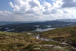 View of the Båttjønndalen valley in Holtålen | |
 Coat of arms 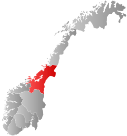 Trøndelag within Norway | |
 Holtålen within Trøndelag | |
| Coordinates: 62°52′07″N 11°16′38″E | |
| Country | Norway |
| County | Trøndelag |
| District | Gauldal |
| Established | 1 Jan 1972 |
| Administrative centre | Renbygda/Ålen |
| Government | |
| • Mayor (2019) | Arve Hitterdal (LL) |
| Area | |
| • Total | 1,209.49 km2 (466.99 sq mi) |
| • Land | 1,170.45 km2 (451.91 sq mi) |
| • Water | 39.04 km2 (15.07 sq mi) 3.2% |
| Area rank | 89 in Norway |
| Population (2020) | |
| • Total | 1,981 |
| • Rank | 282 in Norway |
| • Density | 1.7/km2 (4/sq mi) |
| • Change (10 years) | -4% |
| Demonym(s) | holtåling[1] |
| Time zone | UTC+01:00 (CET) |
| • Summer (DST) | UTC+02:00 (CEST) |
| ISO 3166 code | NO-5026 |
| Official language form | Neutral[2] |
| Website | holtalen |
The 1,209.5-square-kilometre (467.0 sq mi) municipality is the 89th largest by area out of the 356 municipalities in Norway. Holtålen is the 282nd most populous municipality in Norway with a population of 1,981. The municipality's population density is 1.7 inhabitants per square kilometre (4.4/sq mi) and its population has decreased by 4% over the previous 10-year period.[3][4]
General information
.JPG)
The municipality of Holtaalen was established on 1 January 1838 (see formannskapsdistrikt). In 1841, the western part of the municipality was separated to become the municipality of Singsaas. This left Holtaalen with 1,885 residents. Then in 1855, the southeastern part of Holtaalen was separated to become the municipality of Aalen, leaving Holtaalen with 809 residents. The spelling of the name was changed to Holtålen in 1921. In 1937, the name was changed from Holtålen to Haltdalen. On 1 January 1972, the municipality of Haltdalen was merged with the neighboring municipality of Ålen to form the new (present-day) municipality of Holtålen (resurrecting an old name for the area as the name of the new municipality). Prior to the merger, Haltdalen had 778 residents. On 21 April 1989, a small unpopulated part of the neighboring municipality of Røros was transferred to Holtålen.[5] On 1 January 2018, the municipality switched from the old Sør-Trøndelag county to the new Trøndelag county.
Name
The Old Norse forms of the name was Holtdalr and (later) Holtáll. The first element is the old name of the local river Holda. The last element was originally dalr which means "valley" or "dale", but this name was later (around 1400 AD) replaced by the word áll which means "ditch" or "gully" (ålen is the modern definite form of this word). Historically, the spelling was Holtaalen, and in the 20th century the spelling was changed to the current Holtålen.[6]
Coat of arms
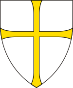
The coat of arms was granted in 1988. The arms show a willow ptarmigan (Lagopus lagopus) in silver or white on a red background. This common local bird was chosen to reflect the importance of hunting in the municipality.[7]
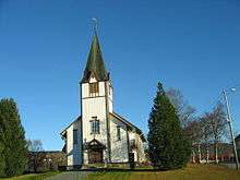
Churches
The Church of Norway has three parishes (sokn) within the municipality of Holtålen. It is part of the Gauldal prosti (deanery) in the Diocese of Nidaros.
| Parish (sokn) | Church Name | Year Built | Location of the Church |
|---|---|---|---|
| Haltdalen | Haltdalen Church | 1881 | Haltdalen |
| Haltdalen Stave Church | 1170 | Trondheim** | |
| Aunegrenda Chapel | 1952 | Aunegrenda | |
| Hessdalen | Hessdalen Church | 1940 | Hessdalen |
| Ålen | Ålen Church | 1881 | Renbygda |
| **This church was moved to a museum in Trondheim, but was originally in Haltdalen. | |||
Geography
.JPG)
The Gauldalen valley with the river Gaula originates from the mountainous area near the mining town of Røros, about 35 kilometres (22 mi) south of Renbygda, which is listed as a World Heritage Site. At the village of Renbygda the deep Gauldalen valley disappears into the mountains, not far from the lake Riasten.
The western part of Holtålen is where the Forollhogna National Park is located with the mountain Forollhogna on the border with Midtre Gauldal municipality. The lake Øyungen lies just outside the park.
The Kjøli and Killingdal copper mines are located in the southeastern part of Holtålen. The last mine in production was Killingdal until it closed down in 1986.
Hessdalen is a mountain valley joining the Gauldal valley close to the village of Renbygda. Around 1983, Hessdalen became famous for UFO observations and the Hessdalen lights. Because of this the Hessdalen AMS station was founded in the valley.
The Rørosbanen railway line runs through the municipality, stopping at the Ålen Station and Haltdalen Station.
Government
All municipalities in Norway, including Holtålen, are responsible for primary education (through 10th grade), outpatient health services, senior citizen services, unemployment and other social services, zoning, economic development, and municipal roads. The municipality is governed by a municipal council of elected representatives, which in turn elect a mayor.[8] The municipality falls under the Sør-Trøndelag District Court and the Frostating Court of Appeal.
Municipal council
The municipal council (Kommunestyre) of Holtålen is made up of 15 representatives that are elected to four-year terms. The party breakdown of the council is as follows:
| Party Name (in Norwegian) | Number of representatives | |
|---|---|---|
| Labour Party (Arbeiderpartiet) | 7 | |
| Pensioners' Party (Pensjonistpartiet) | 1 | |
| Centre Party (Senterpartiet) | 4 | |
| Future Holtålen (Framtida Holtålen) | 3 | |
| Total number of members: | 15 | |
| Party Name (in Norwegian) | Number of representatives | |
|---|---|---|
| Labour Party (Arbeiderpartiet) | 7 | |
| Conservative Party (Høyre) | 1 | |
| Socialist Left Party (Sosialistisk Venstreparti) | 1 | |
| Joint list of the Centre Party (Senterpartiet) and the Liberal Party (Venstre) | 6 | |
| Total number of members: | 15 | |
| Party Name (in Norwegian) | Number of representatives | |
|---|---|---|
| Labour Party (Arbeiderpartiet) | 8 | |
| Conservative Party (Høyre) | 4 | |
| Socialist Left Party (Sosialistisk Venstreparti) | 1 | |
| Joint list of the Centre Party (Senterpartiet), Christian Democratic Party (Kristelig Folkeparti), and Liberal Party (Venstre) | 8 | |
| Total number of members: | 21 | |
| Party Name (in Norwegian) | Number of representatives | |
|---|---|---|
| Labour Party (Arbeiderpartiet) | 11 | |
| Socialist Left Party (Sosialistisk Venstreparti) | 2 | |
| Joint list of the Conservative Party (Høyre), Christian Democratic Party (Kristelig Folkeparti), Centre Party (Senterpartiet), and Liberal Party (Venstre) | 8 | |
| Total number of members: | 21 | |
| Party Name (in Norwegian) | Number of representatives | |
|---|---|---|
| Labour Party (Arbeiderpartiet) | 12 | |
| Joint list of the Conservative Party (Høyre), Christian Democratic Party (Kristelig Folkeparti), Centre Party (Senterpartiet), and Liberal Party (Venstre) | 9 | |
| Total number of members: | 21 | |
| Party Name (in Norwegian) | Number of representatives | |
|---|---|---|
| Labour Party (Arbeiderpartiet) | 11 | |
| Socialist Left Party (Sosialistisk Venstreparti) | 3 | |
| Holtålen List (Holtålenlista) | 7 | |
| Total number of members: | 21 | |
| Party Name (in Norwegian) | Number of representatives | |
|---|---|---|
| Labour Party (Arbeiderpartiet) | 12 | |
| Conservative Party (Høyre) | 1 | |
| Centre Party (Senterpartiet) | 4 | |
| Socialist Left Party (Sosialistisk Venstreparti) | 2 | |
| Holtålen local list (Holtålen Bygdeliste) | 2 | |
| Total number of members: | 21 | |
| Party Name (in Norwegian) | Number of representatives | |
|---|---|---|
| Labour Party (Arbeiderpartiet) | 11 | |
| Socialist Left Party (Sosialistisk Venstreparti) | 4 | |
| Joint list of the Conservative Party (Høyre), Christian Democratic Party (Kristelig Folkeparti), and Centre Party (Senterpartiet) | 4 | |
| Local list for Holtålen (Bygdaliste for Holtålen) | 2 | |
| Total number of members: | 21 | |
| Party Name (in Norwegian) | Number of representatives | |
|---|---|---|
| Labour Party (Arbeiderpartiet) | 13 | |
| Socialist Left Party (Sosialistisk Venstreparti) | 3 | |
| Joint list of the Conservative Party (Høyre), Christian Democratic Party (Kristelig Folkeparti), and Centre Party (Senterpartiet) | 5 | |
| Total number of members: | 21 | |
| Party Name (in Norwegian) | Number of representatives | |
|---|---|---|
| Labour Party (Arbeiderpartiet) | 14 | |
| Conservative Party (Høyre) | 1 | |
| Socialist Left Party (Sosialistisk Venstreparti) | 3 | |
| Joint list of the Centre Party (Senterpartiet) and the Christian Democratic Party (Kristelig Folkeparti) | 3 | |
| Total number of members: | 21 | |
| Party Name (in Norwegian) | Number of representatives | |
|---|---|---|
| Labour Party (Arbeiderpartiet) | 13 | |
| Conservative Party (Høyre) | 1 | |
| Socialist Left Party (Sosialistisk Venstreparti) | 2 | |
| Joint list of the Centre Party (Senterpartiet), Christian Democratic Party (Kristelig Folkeparti), and Liberal Party (Venstre) | 5 | |
| Total number of members: | 21 | |
| Party Name (in Norwegian) | Number of representatives | |
|---|---|---|
| Labour Party (Arbeiderpartiet) | 13 | |
| Socialist Left Party (Sosialistisk Venstreparti) | 2 | |
| Joint list of the Centre Party (Senterpartiet) and the Christian Democratic Party (Kristelig Folkeparti) | 6 | |
| Total number of members: | 21 | |
| Party Name (in Norwegian) | Number of representatives | |
|---|---|---|
| Labour Party (Arbeiderpartiet) | 15 | |
| Christian Democratic Party (Kristelig Folkeparti) | 2 | |
| Joint List(s) of Non-Socialist Parties (Borgerlige Felleslister) | 3 | |
| Local List(s) (Lokale lister) | 1 | |
| Total number of members: | 21 | |
Mayor
The mayors of Holtålen (incomplete list):
- 2019–present: Arve Hitterdal (LL)
- 2015–2019: Jan Håvard Refsethås (Sp)
- 2011–2015: Heidi Greni (Sp)
- 1991–2011: Ivar Volden (Ap)
References
- "Navn på steder og personer: Innbyggjarnamn" (in Norwegian). Språkrådet.
- "Forskrift om målvedtak i kommunar og fylkeskommunar" (in Norwegian). Lovdata.no.
- Statistisk sentralbyrå (2020). "Table: 06913: Population 1 January and population changes during the calendar year (M)" (in Norwegian).
- Statistisk sentralbyrå (2020). "09280: Area of land and fresh water (km²) (M)" (in Norwegian).
- Jukvam, Dag (1999). "Historisk oversikt over endringer i kommune- og fylkesinndelingen" (PDF) (in Norwegian). Statistisk sentralbyrå.
- Rygh, Oluf (1901). Norske gaardnavne: Søndre Trondhjems amt (in Norwegian) (14 ed.). Kristiania, Norge: W. C. Fabritius & sønners bogtrikkeri. p. 220.
- "Civic heraldry of Norway – Norske Kommunevåpen". Heraldry of the World. Retrieved 20 January 2018.
- Hansen, Tore, ed. (12 May 2016). "kommunestyre". Store norske leksikon (in Norwegian). Kunnskapsforlaget. Retrieved 1 January 2019.
- "Tall for Norge: Kommunestyrevalg 2019 – Trøndelag". Valg Direktoratet. Retrieved 19 October 2019.
- "Table: 04813: Members of the local councils, by party/electoral list at the Municipal Council election (M)" (in Norwegian). Statistics Norway.
- "Tall for Norge: Kommunestyrevalg 2011 – Sør-Trøndelag". Valg Direktoratet. Retrieved 19 October 2019.
- "Kommunestyrevalget 1995" (PDF) (in Norwegian). Oslo-Kongsvinger: Statistisk sentralbyrå. 1996. Retrieved 23 June 2020.
- "Kommunestyrevalget 1991" (PDF) (in Norwegian). Oslo-Kongsvinger: Statistisk sentralbyrå. 1993. Retrieved 23 June 2020.
- "Kommunestyrevalget 1987" (PDF) (in Norwegian). Oslo-Kongsvinger: Statistisk sentralbyrå. 1988. Retrieved 23 June 2020.
- "Kommunestyrevalget 1983" (PDF) (in Norwegian). Oslo-Kongsvinger: Statistisk sentralbyrå. 1984. Retrieved 23 June 2020.
- "Kommunestyrevalget 1979" (PDF) (in Norwegian). Oslo: Statistisk sentralbyrå. 1979. Retrieved 23 June 2020.
- "Kommunevalgene 1975" (PDF) (in Norwegian). Oslo: Statistisk sentralbyrå. 1977. Retrieved 23 June 2020.
- "Kommunevalgene 1972" (PDF) (in Norwegian). Oslo: Statistisk sentralbyrå. 1973. Retrieved 23 June 2020.
External links
| Wikimedia Commons has media related to Holtålen. |

- Municipal fact sheet from Statistics Norway (in Norwegian)
 |
|  | |||||||||||||||||||||||
||