Frøya, Trøndelag
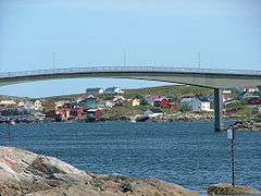
Frøya is the westernmost municipality in Trøndelag county, Norway. It is part of the Fosen region and consists of the island of Frøya, which lies north of the island of Hitra, as well several thousand other small islands surrounding the island of Frøya. The village of Sistranda is the administrative center of Frøya. Other villages include Hammarvika, Titran, Sula, and Mausund. The main island of Frøya is connected to the neighboring island of Hitra (and ultimately the mainland of Norway) by the Frøya Tunnel which goes under the Frøyfjorden.[3]
Frøya kommune | |
|---|---|
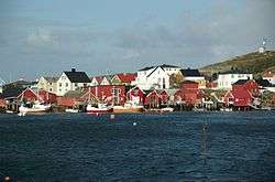 View of the village of Sula | |
 Flag  Coat of arms 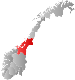 Trøndelag within Norway | |
 Frøya within Trøndelag | |
| Coordinates: 63°43′32″N 08°44′39″E | |
| Country | Norway |
| County | Trøndelag |
| District | Fosen |
| Established | 1877-1906 |
| Re-established | 1 Jan 1964 |
| Administrative centre | Sistranda |
| Government | |
| • Mayor (2019) | Kristin Furunes Strømskag (H) |
| Area | |
| • Total | 241.31 km2 (93.17 sq mi) |
| • Land | 229.92 km2 (88.77 sq mi) |
| • Water | 11.39 km2 (4.40 sq mi) 4.7% |
| Area rank | 291 in Norway |
| Population (2020) | |
| • Total | 5,151 |
| • Rank | 179 in Norway |
| • Density | 22.4/km2 (58/sq mi) |
| • Change (10 years) | 19.4% |
| Demonym(s) | Frøyværing[1] |
| Time zone | UTC+01:00 (CET) |
| • Summer (DST) | UTC+02:00 (CEST) |
| ISO 3166 code | NO-5014 |
| Official language form | Bokmål[2] |
| Website | froya |
The 241-square-kilometre (93 sq mi) municipality is the 291st largest by area out of the 356 municipalities in Norway. Frøya is the 179th most populous municipality in Norway with a population of 5,151. The municipality's population density is 22.4 inhabitants per square kilometre (58/sq mi), and its population has increased by 19.4% over the previous 10-year period.[4][5]
General information
The parish of Frøya was established as a municipality on 1 January 1877 when it was separated from the municipality of Hitra. Its initial population was 3,949. On 1 January 1906, it was split into two municipalities: Nord-Frøya in the north and Sør-Frøya in the south. During the 1960s, there were many municipal mergers across Norway due to the work of the Schei Committee. On 1 January 1964, Nord-Frøya and Sør-Frøya were merged back together again, forming a new municipality of Frøya.[6] On 1 January 2018, the municipality switched from the old Sør-Trøndelag county to the new Trøndelag county.
Name
The name of the island and municipality come from Norse mythology. Although Frøya is a variant of the name of the Norse goddess Freyja, the Old Norse form of the name of the island was Frøy or Frey (the ending -a in the modern form is actually the feminine definite article - so the meaning of Frøya is 'the Frøy'). Therefore, the name of the island probably has the same root as the name of the Norse god Freyr, brother to Freyja. The names originally were titles: "lord" or "lady". The oldest meaning of the common word was "(the one) in front; the foremost, the leading" and here in the sense "the island in front of Hitra". Until 1906 the island and municipality name was spelled Frøien (-en is the masculine definite article in Norwegian).[7]
Coat of arms
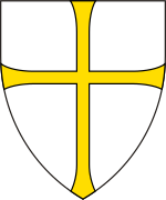
The coat of arms was granted on 13 March 1987. The arms show three silver fish hooks made of bone from the Stone Age on a blue background. The hooks symbolize the importance of fishing and trapping to the people of Frøya.[3][8]
Churches
The Church of Norway has one parish (sokn) within the municipality of Frøya. It is part of the Orkdal prosti (deanery) in the Diocese of Nidaros.
| Parish (sokn) | Church Name | Location of the Church | Year Built |
|---|---|---|---|
| Frøya | Sletta Church | Nord-Frøya (Berge) | 1990 |
| Hallaren Church | Storhallaren | 1881 | |
| Froan Chapel | Froan (Sauøya) | 1904 | |
| Måøy Chapel | Mausund (Måøya) | 1939 | |
| Sula Chapel | Sula | 1925 | |
| Titran Chapel | Titran | 1873 |
Government
All municipalities in Norway, including Frøya, are responsible for primary education (through 10th grade), outpatient health services, senior citizen services, unemployment and other social services, zoning, economic development, and municipal roads. The municipality is governed by a municipal council of elected representatives, which in turn elect a mayor.[9] The municipality falls under the Fosen District Court and the Frostating Court of Appeal.
Municipal council
The municipal council (Kommunestyre) of Frøya is made up of 23 representatives that are elected to four year terms. The party breakdown of the council is as follows:
| Party Name (in Norwegian) | Number of representatives | |
|---|---|---|
| Labour Party (Arbeiderpartiet) | 7 | |
| Progress Party (Fremskrittspartiet) | 2 | |
| Conservative Party (Høyre) | 3 | |
| Pensioners' Party (Pensjonistpartiet) | 1 | |
| Red Party (Rødt) | 2 | |
| Centre Party (Senterpartiet) | 5 | |
| Socialist Left Party (Sosialistisk Venstreparti) | 1 | |
| Liberal Party (Venstre) | 2 | |
| Total number of members: | 23 | |
| Party Name (in Norwegian) | Number of representatives | |
|---|---|---|
| Labour Party (Arbeiderpartiet) | 12 | |
| Progress Party (Fremskrittspartiet) | 3 | |
| Conservative Party (Høyre) | 2 | |
| Centre Party (Senterpartiet) | 1 | |
| Socialist Left Party (Sosialistisk Venstreparti) | 1 | |
| Liberal Party (Venstre) | 4 | |
| Total number of members: | 23 | |
| Party Name (in Norwegian) | Number of representatives | |
|---|---|---|
| Labour Party (Arbeiderpartiet) | 10 | |
| Progress Party (Fremskrittspartiet) | 5 | |
| Conservative Party (Høyre) | 2 | |
| Centre Party (Senterpartiet) | 1 | |
| Socialist Left Party (Sosialistisk Venstreparti) | 1 | |
| Liberal Party (Venstre) | 4 | |
| Total number of members: | 23 | |
| Party Name (in Norwegian) | Number of representatives | |
|---|---|---|
| Labour Party (Arbeiderpartiet) | 7 | |
| Progress Party (Fremskrittspartiet) | 5 | |
| Conservative Party (Høyre) | 2 | |
| Christian Democratic Party (Kristelig Folkeparti) | 1 | |
| Centre Party (Senterpartiet) | 1 | |
| Socialist Left Party (Sosialistisk Venstreparti) | 2 | |
| Liberal Party (Venstre) | 5 | |
| Total number of members: | 23 | |
| Party Name (in Norwegian) | Number of representatives | |
|---|---|---|
| Labour Party (Arbeiderpartiet) | 7 | |
| Progress Party (Fremskrittspartiet) | 3 | |
| Conservative Party (Høyre) | 3 | |
| Christian Democratic Party (Kristelig Folkeparti) | 2 | |
| Centre Party (Senterpartiet) | 2 | |
| Socialist Left Party (Sosialistisk Venstreparti) | 2 | |
| Liberal Party (Venstre) | 4 | |
| Total number of members: | 23 | |
| Party Name (in Norwegian) | Number of representatives | |
|---|---|---|
| Labour Party (Arbeiderpartiet) | 11 | |
| Progress Party (Fremskrittspartiet) | 1 | |
| Conservative Party (Høyre) | 4 | |
| Christian Democratic Party (Kristelig Folkeparti) | 2 | |
| Centre Party (Senterpartiet) | 2 | |
| Socialist Left Party (Sosialistisk Venstreparti) | 1 | |
| Liberal Party (Venstre) | 2 | |
| Total number of members: | 23 | |
| Party Name (in Norwegian) | Number of representatives | |
|---|---|---|
| Labour Party (Arbeiderpartiet) | 16 | |
| Progress Party (Fremskrittspartiet) | 1 | |
| Conservative Party (Høyre) | 3 | |
| Christian Democratic Party (Kristelig Folkeparti) | 2 | |
| Centre Party (Senterpartiet) | 3 | |
| Socialist Left Party (Sosialistisk Venstreparti) | 2 | |
| Liberal Party (Venstre) | 2 | |
| Total number of members: | 29 | |
| Party Name (in Norwegian) | Number of representatives | |
|---|---|---|
| Labour Party (Arbeiderpartiet) | 15 | |
| Progress Party (Fremskrittspartiet) | 1 | |
| Conservative Party (Høyre) | 3 | |
| Christian Democratic Party (Kristelig Folkeparti) | 2 | |
| Centre Party (Senterpartiet) | 3 | |
| Socialist Left Party (Sosialistisk Venstreparti) | 2 | |
| Liberal Party (Venstre) | 1 | |
| Joint list of the Pensioners' Party and the Pensioner and insured list (Pensjonistpartiet, Pensjonister og Trygdedes liste) | 2 | |
| Total number of members: | 29 | |
| Party Name (in Norwegian) | Number of representatives | |
|---|---|---|
| Labour Party (Arbeiderpartiet) | 12 | |
| Conservative Party (Høyre) | 4 | |
| Christian Democratic Party (Kristelig Folkeparti) | 4 | |
| Pensioners' Party (Pensjonistpartiet) | 2 | |
| Centre Party (Senterpartiet) | 3 | |
| Socialist Left Party (Sosialistisk Venstreparti) | 1 | |
| Liberal Party (Venstre) | 3 | |
| Total number of members: | 29 | |
| Party Name (in Norwegian) | Number of representatives | |
|---|---|---|
| Labour Party (Arbeiderpartiet) | 13 | |
| Conservative Party (Høyre) | 5 | |
| Christian Democratic Party (Kristelig Folkeparti) | 6 | |
| Centre Party (Senterpartiet) | 4 | |
| Socialist Left Party (Sosialistisk Venstreparti) | 1 | |
| Liberal Party (Venstre) | 4 | |
| Total number of members: | 33 | |
| Party Name (in Norwegian) | Number of representatives | |
|---|---|---|
| Labour Party (Arbeiderpartiet) | 10 | |
| Conservative Party (Høyre) | 5 | |
| Christian Democratic Party (Kristelig Folkeparti) | 4 | |
| Centre Party (Senterpartiet) | 5 | |
| Liberal Party (Venstre) | 4 | |
| Non-party list (Upolitisk liste) | 5 | |
| Total number of members: | 33 | |
| Party Name (in Norwegian) | Number of representatives | |
|---|---|---|
| Labour Party (Arbeiderpartiet) | 15 | |
| Conservative Party (Høyre) | 4 | |
| Christian Democratic Party (Kristelig Folkeparti) | 7 | |
| Centre Party (Senterpartiet) | 7 | |
| Socialist Left Party (Sosialistisk Venstreparti) | 1 | |
| Liberal Party (Venstre) | 3 | |
| Total number of members: | 37 | |
| Party Name (in Norwegian) | Number of representatives | |
|---|---|---|
| Labour Party (Arbeiderpartiet) | 19 | |
| Conservative Party (Høyre) | 5 | |
| Christian Democratic Party (Kristelig Folkeparti) | 5 | |
| Centre Party (Senterpartiet) | 3 | |
| Socialist People's Party (Sosialistisk Folkeparti) | 1 | |
| Liberal Party (Venstre) | 4 | |
| Total number of members: | 37 | |
| Party Name (in Norwegian) | Number of representatives | |
|---|---|---|
| Labour Party (Arbeiderpartiet) | 17 | |
| Conservative Party (Høyre) | 6 | |
| Christian Democratic Party (Kristelig Folkeparti) | 5 | |
| Socialist People's Party (Sosialistisk Folkeparti) | 1 | |
| Liberal Party (Venstre) | 6 | |
| Local List(s) (Lokale lister) | 2 | |
| Total number of members: | 37 | |
| Party Name (in Norwegian) | Number of representatives | |
|---|---|---|
| Labour Party (Arbeiderpartiet) | 18 | |
| Conservative Party (Høyre) | 7 | |
| Christian Democratic Party (Kristelig Folkeparti) | 6 | |
| Liberal Party (Venstre) | 6 | |
| Total number of members: | 37 | |
Mayor
The mayors of Frøya (incomplete list):
- 2019-present: Kristin Furunes Strømskag (H)
- 2011-2019: Berit Flåmo (Ap)
- 2007-2011: Hans Stølan (Ap)
- 2003-2007: Arvid Hammernes (V)
- 1987-2003: Jan Otto Fredagsvik (Ap)
- 1979-1987: Sigbjørn Larsen (KrF)
Geography
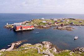
The municipality of Frøya has many small fishing communities on the large island of Frøya and many small islands in the ocean such as Mausundvær, Bogøyvær, and Sula, with Mausund being the largest of these with a population of approximately 270. Other small islands such as Froan and Halten, Trøndelag lay to the northeast of the island of Frøya. Many of these islands are home to lighthouses such as Halten Lighthouse, Finnvær Lighthouse, Vingleia Lighthouse, Sula Lighthouse, and Sletringen Lighthouse.
The main island of Frøya is fairly open and has no natural forests–mostly covered with marshes and heather. The largest villages on the island are Sistranda in the east and Titran in the west. Frøya is a member of the International Island Games Association. The highest point above sea level is the 76-metre (249 ft) tall Besselvassheia, and the second highest point is the 74-metre (243 ft) tall Bremnestua.[22]
Climate
Frøya has a distinct temperate oceanic climate (Cfb), with a year amplitude of only 11 °C (20 °F) from the coldest to the warmest month, and a small diurnal temperature variation. Mean annual precipitation is 1,200 millimetres (47 in). The wettest season is September - January, while May - June is the driest with approximately 60 millimetres (2.4 in) precipitation each month.
| Climate data for Frøya (Sør-Trøndelag) | |||||||||||||
|---|---|---|---|---|---|---|---|---|---|---|---|---|---|
| Month | Jan | Feb | Mar | Apr | May | Jun | Jul | Aug | Sep | Oct | Nov | Dec | Year |
| Average high °C (°F) | 4 (39) |
4 (39) |
4 (39) |
7 (45) |
10 (50) |
12 (54) |
15 (59) |
15 (59) |
13 (55) |
10 (50) |
7 (45) |
5 (41) |
9 (48) |
| Average low °C (°F) | 2 (36) |
1 (34) |
2 (36) |
4 (39) |
7 (45) |
10 (50) |
12 (54) |
12 (54) |
11 (52) |
7 (45) |
4 (39) |
3 (37) |
6 (43) |
| Source: Storm Weather Center[23] | |||||||||||||
Notable residents
- Norwegian American John A. Widtsoe (1872–1952) was born and lived here for the first twelve years of his life.
References
- "Navn på steder og personer: Innbyggjarnamn" (in Norwegian). Språkrådet.
- "Forskrift om målvedtak i kommunar og fylkeskommunar" (in Norwegian). Lovdata.no.
- Haugen, Morten, ed. (12 September 2017). "Frøya – kommune". Store norske leksikon (in Norwegian). Kunnskapsforlaget. Retrieved 2 October 2017.
- Statistisk sentralbyrå (2020). "Table: 06913: Population 1 January and population changes during the calendar year (M)" (in Norwegian).
- Statistisk sentralbyrå (2020). "09280: Area of land and fresh water (km²) (M)" (in Norwegian).
- Jukvam, Dag (1999). "Historisk oversikt over endringer i kommune- og fylkesinndelingen" (PDF) (in Norwegian). Statistisk sentralbyrå.
- Rygh, Oluf (1901). Norske gaardnavne: Søndre Trondhjems amt (in Norwegian) (14 ed.). Kristiania, Norge: W. C. Fabritius & sønners bogtrikkeri. p. 55.
- "Civic heraldry of Norway - Norske Kommunevåpen". Heraldry of the World. Retrieved 24 February 2018.
- Hansen, Tore, ed. (12 May 2016). "kommunestyre". Store norske leksikon (in Norwegian). Kunnskapsforlaget. Retrieved 1 January 2019.
- "Tall for Norge: Kommunestyrevalg 2019 - Trøndelag". Valg Direktoratet. Retrieved 19 October 2019.
- "Table: 04813: Members of the local councils, by party/electoral list at the Municipal Council election (M)" (in Norwegian). Statistics Norway.
- "Tall for Norge: Kommunestyrevalg 2011 - Sør-Trøndelag". Valg Direktoratet. Retrieved 19 October 2019.
- "Kommunestyrevalget 1995" (PDF) (in Norwegian). Oslo-Kongsvinger: Statistisk sentralbyrå. 1996. Retrieved 12 April 2020.
- "Kommunestyrevalget 1991" (PDF) (in Norwegian). Oslo-Kongsvinger: Statistisk sentralbyrå. 1993. Retrieved 12 April 2020.
- "Kommunestyrevalget 1987" (PDF) (in Norwegian). Oslo-Kongsvinger: Statistisk sentralbyrå. 1988. Retrieved 12 April 2020.
- "Kommunestyrevalget 1983" (PDF) (in Norwegian). Oslo-Kongsvinger: Statistisk sentralbyrå. 1984. Retrieved 12 April 2020.
- "Kommunestyrevalget 1979" (PDF) (in Norwegian). Oslo: Statistisk sentralbyrå. 1979. Retrieved 12 April 2020.
- "Kommunevalgene 1975" (PDF) (in Norwegian). Oslo: Statistisk sentralbyrå. 1977. Retrieved 12 April 2020.
- "Kommunevalgene 1972" (PDF) (in Norwegian). Oslo: Statistisk sentralbyrå. 1973. Retrieved 12 April 2020.
- "Kommunevalgene 1967" (PDF) (in Norwegian). Oslo: Statistisk sentralbyrå. 1967. Retrieved 12 April 2020.
- "Kommunevalgene 1963" (PDF) (in Norwegian). Oslo: Statistisk sentralbyrå. 1964. Retrieved 12 April 2020.
- "Frøya - The islands against the big ocean!". trondelagskysten.no. Archived from the original on 24 July 2011. Retrieved 17 November 2010.
- "Frøya average conditions-base period 10 last years". Storm Weather Center. Archived from the original on 24 July 2011. Retrieved 5 December 2009.
External links
| Wikimedia Commons has media related to Frøya. |

- Municipal fact sheet from Statistics Norway (in Norwegian)
 |
|  | |||||||||||||||||||||||
||