Indiana State Road 57
State Road 57 (SR 57) in the U.S. state of Indiana is a north–south, largely two-lane road in the southwestern portion of the state.
| ||||
|---|---|---|---|---|
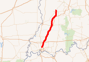
SR 57 highlighted in red | ||||
| Route information | ||||
| Maintained by INDOT | ||||
| Length | 83.19 mi[1] (133.88 km) | |||
| Existed | October 1, 1926[2]–present | |||
| Major junctions | ||||
| South end | ||||
| North end | ||||
| Location | ||||
| Counties | Daviess, Gibson, Greene, Pike, Vanderburgh | |||
| Highway system | ||||
| ||||

Route description
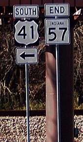
SR 57 begins at U.S. Highway 41 in Evansville and provides access to Evansville Regional Airport. It is routed concurrently with Interstate 69 to SR 68 just north of Interstate 64 then is concurrent with SR 68 for roughly 1 mile before resuming its original route. The highway serves a number of small communities and the cities of Oakland City, Petersburg and Washington. The final few miles of SR 57 are concurrent with US 231. SR 57 ends at the south junction of US 231 and SR 67, three miles (4.8 km) southwest of Worthington.
In 2009, a portion of SR 57 was relocated onto the new I-69 route and overlapped with SR 68. The original route has been removed and now exists only as a service road to the Warrick County Industrial Park.
Prior to Interstate 69, SR 57 had been a frequently congested highway with a number of dangerous intersections, such as SR 68 near Haubstadt, SR 168 in Mackey, SR 64 in Oakland City, SR 56 and SR 61 in Petersburg, US 50 in Washington and SR 58 in Elnora. The road had been widened in a number of spots to accommodate the heavy volume.
Major intersections
| County | Location | mi[1] | km | Destinations | Notes |
|---|---|---|---|---|---|
| Vanderburgh | Evansville | 0.00 | 0.00 | Southern terminus of SR 57 | |
| Scott Township | 8.63 | 13.89 | Southern end of I-69 concurrency, Former I-164 | ||
| Gibson | Johnson Township | 10.06 | 16.19 | Former Northern Terminus of I-164, Former Southern Terminus of I-69 | |
| Warrick | Greer Township | 11.66 | 18.76 | Northern end of I-69 concurrency; western end of SR 68 concurrency | |
| Eastern end of SR 68 concurrency | |||||
| Gibson | Mackey | 17.35 | 27.92 | Eastern terminus of SR 168 | |
| Oakland City | 22.71 | 36.55 | |||
| 24.89 | 40.06 | Northern terminus of SR 357 | |||
| Pike | Petersburg | 35.57 | 57.24 | Western end of SR 56 concurrency | |
| 36.09 | 58.08 | Northern terminus of concurrency of SR 56 after 0.52 mi. | |||
| 36.24 | 58.32 | Western terminus of SR 356 | |||
| Daviess | Washington | 47.67 | 76.72 | ||
| Plainville | 60.43 | 97.25 | Southern end of SR 358 concurrency | ||
| Elmore Township | 63.98 | 102.97 | Northern end of SR 358 concurrency | ||
| Elnora | 66.62 | 107.21 | Western end of SR 58 concurrency | ||
| 66.74 | 107.41 | Eastern end of SR 58 concurrency | |||
| Greene | Fairplay Township | 79.90 | 128.59 | Southern end of US 231 concurrency | |
| 83.19 | 133.88 | Northern end of US 231 concurrency; northern terminus of SR 57 | |||
1.000 mi = 1.609 km; 1.000 km = 0.621 mi
| |||||
References
- Indiana Department of Transportation (2004). Reference Post Book (PDF). Indianapolis: Indiana Department of Transportation. Archived (PDF) from the original on October 6, 2014.
- "Road Numbers to Be Changed". The Hancock-Democrat. The Indianapolis News. September 30, 1926. Retrieved June 9, 2016 – via Newspapers.com.
