Indiana State Road 356
State Road 356 in the U.S. state of Indiana consists of two segments, both in the southern portion of the state. The western segment is about 10 miles long, and the eastern segment is about 15 miles long.
| ||||
|---|---|---|---|---|
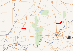
SR 356 highlighted in red | ||||
| Route information | ||||
| Maintained by INDOT | ||||
| Length | 25.270 mi[1] (40.668 km) | |||
| Existed | 1932[2]–present | |||
| Western section | ||||
| Length | 9.911 mi[1] (15.950 km) | |||
| South end | ||||
| North end | ||||
| Eastern section | ||||
| Length | 15.359 mi[1] (24.718 km) | |||
| South end | ||||
| North end | ||||
| Location | ||||
| Counties | Pike, Scott, Jefferson | |||
| Highway system | ||||
| ||||

Route description
Western section
The western segment SR 356 starts at an intersection with SR 57 in downtown Petersburg and travels eastward. The road travels through the east side of Petersburg before entering rural Pike County, traveling through farmland. SR 356 passes through Alford before crossing over Interstate 69 (I-69). After crossing I-69, SR 356 passes through Algiers before ending at a three-way junction with SR 257, northwest of Otwell.
Eastern section
The eastern section of SR 356 starts at a junction with US 31 west of Vienna and travels eastward. The road crosses the Louisville and Indiana Railroad before passing through Vienna. After Vienna SR 356 travels across farmland in Scott County before having a four-way intersection with SR 3. The highway continues east entering the town of Lexington. In downtown Lexington SR 356 has a short concurrency with SR 203 before leaving Lexington. East of Lexington SR 356 curves towards the northeast and enters Jefferson County. SR 356 ends at a three-way junction with SR 62, just south of the intersection between SR 56 and SR 62, a few miles west of Hanover, in rural Jefferson County.
History
SR 356 was commissioned in 1932 routed between Lexington and SR 62.[2] Between 1939 and 1941 the route was extended west to US 31, in Vienna. The western segment of SR 356, between SR 57 and SR 257 was also added to the state road system at this time.[3][4] Both segment of SR 356 were paved around 1966.[5][6]
Major intersections
| County | Location | mi[1] | km | Destinations | Notes | ||
|---|---|---|---|---|---|---|---|
| Pike | Petersburg | 0.000 | 0.000 | Western terminus of SR 356 | |||
| Jefferson Township | 9.911 | 15.950 | Eastern terminus of the western section of SR 356 | ||||
| Gap in route | |||||||
| Scott | Vienna | 9.912 | 15.952 | Western terminus of the eastern section of SR 356 | |||
| Scott County | 14.461 | 23.273 | |||||
| Lexington | 17.952 | 28.891 | Western end of SR 203 concurrency | ||||
| 18.113 | 29.150 | Eastern end of SR 203 concurrency | |||||
| Jefferson | Hanover Township | 25.270 | 40.668 | Eastern terminus of SR 356 | |||
1.000 mi = 1.609 km; 1.000 km = 0.621 mi
| |||||||
References
- Indiana Department of Transportation (July 2016). Reference Post Book (PDF). Indianapolis: Indiana Department of Transportation. Retrieved February 2, 2017.
- "Nearly 1,000 Miles of Roads Absorbed". The Franklin Evening Star. April 22, 1932. p. 5. Retrieved August 25, 2016 – via Newspapers.com.

- Indiana State Highway Commission (1939). State Highway System of Indiana (Map). 1:633,600. Indiana State Highway Commission. OCLC 64016573. Retrieved September 4, 2018 – via Indiana State Library and Historical Bureau.
- Indiana State Highway Commission (1941). State Highway System of Indiana (Map). 1:633,600. Indiana State Highway Commission. OCLC 64574634. Retrieved September 4, 2018 – via Indiana State Library and Historical Bureau.
- Indiana State Highway Commission (1966). Indiana State Highway System (Map) (1966–1967 ed.). 1:640,000. Indiana State Highway Commission. OCLC 65209231. Retrieved September 4, 2018 – via Indiana State Library and Historical Bureau.
- Indiana State Highway Commission (1967). Indiana State Highway System (Map) (1967–1968 ed.). 1:640,000. Indiana State Highway Commission. OCLC 65221593. Retrieved September 4, 2018 – via Indiana State Library and Historical Bureau.