Indiana State Road 358
State Road 358 in the U.S. state of Indiana is an east–west state highway in Knox and Daviess counties, covering a distance of about 12 miles.
| ||||
|---|---|---|---|---|
 | ||||
| Route information | ||||
| Maintained by INDOT | ||||
| Length | 12.146 mi[1] (19.547 km) | |||
| Major junctions | ||||
| West end | ||||
| East end | ||||
| Location | ||||
| Counties | Knox, Daviess | |||
| Highway system | ||||
| ||||

Route description
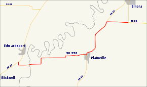
State Road 358 starts at State Road 67 near the small town of Edwardsport and runs east to Plainville. It is then concurrent with State Road 57 and runs northeast for about 3 miles (4.8 km) before striking east again for the last two miles (3 km) of its length, where it meets State Road 58 south of Elnora.
Major intersections
| County | Location | mi[1] | km | Destinations | Notes |
|---|---|---|---|---|---|
| Knox | Edwardsport | 0.000 | 0.000 | Western terminus of SR 358 | |
| Daviess | Plainville | 6.626 | 10.664 | Southern end of SR 57 concurrency | |
| Elmore Township | 10.174 | 16.373 | Northern terminus of SR 57 concurrency | ||
| 12.146 | 19.547 | Eastern terminus of SR 358 | |||
1.000 mi = 1.609 km; 1.000 km = 0.621 mi
| |||||
References
- Indiana Department of Transportation (July 2016). Reference Post Book (PDF). Indianapolis: Indiana Department of Transportation. Retrieved February 2, 2017.
External links
This article is issued from Wikipedia. The text is licensed under Creative Commons - Attribution - Sharealike. Additional terms may apply for the media files.