Indiana State Road 68
State Road 68 in the U.S. State of Indiana is a 53-mile (85 km) route in Gibson, Posey, Spencer and Warrick counties.
| ||||
|---|---|---|---|---|
 | ||||
| Route information | ||||
| Maintained by INDOT | ||||
| Length | 52.927 mi[1] (85.178 km) | |||
| Existed | 1931[2]–present | |||
| Major junctions | ||||
| West end | ||||
| East end | ||||
| Location | ||||
| Counties | Gibson, Posey, Spencer, Warrick | |||
| Highway system | ||||
| ||||

Route description
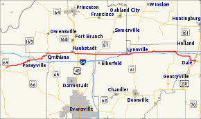
State Road 68 begins in New Harmony at State Road 69 and runs east, passing through the towns of Poseyville, Cynthiana, Haubstadt, Lynnville and Selvin. State Road 68 nearly parallels Interstate 64, but although it passes over the interstate twice, there is no direct interchange. However, as of 2008, it now has an interchange with Interstate 69, making it one of the few roads in the state to cross both the state level equivalent and the Interstate equivalent, in this case being 69. It ends at US 231 in the town of Dale.
Major intersections
| County | Location | mi[1] | km | Destinations | Notes |
|---|---|---|---|---|---|
| Posey | Harmony Township | 0.000 | 0.000 | Western terminus of SR 68 | |
| Poseyville | 6.425 | 10.340 | Western end of SR 165 concurrency | ||
| 7.399 | 11.908 | Eastern end of SR 165 concurrency | |||
| Cynthiana | 11.813 | 19.011 | Western end of SR 65 concurrency | ||
| 13.204 | 21.250 | Eastern end of SR 65 concurrency | |||
| Gibson | Haubstadt | 21.398 | 34.437 | ||
| Gibson–Warrick county line | Johnson–Greer township line | 25.765– 25.888 | 41.465– 41.663 | Western end of SR 57 concurrency | |
| Warrick | Greer Township | 26.404 | 42.493 | Eastern end of SR 57 concurrency | |
| Lynnville | 35.235 | 56.705 | |||
| Pigeon Township | 46.651 | 75.078 | Western end of SR 161 concurrency | ||
| 50.122 | 80.664 | Eastern end of SR 161 concurrnecy | |||
| Spencer | Dale | 52.927 | 85.178 | Eastern terminus of SR 68 | |
1.000 mi = 1.609 km; 1.000 km = 0.621 mi
| |||||
References
- Indiana Department of Transportation (July 2016). Reference Post Book (PDF). Indianapolis: Indiana Department of Transportation. Retrieved April 10, 2017.
- "Roads Added to State System". The Daily Reporter. Greenfield. May 15, 1931. Retrieved October 20, 2016 – via Newspapers.com.

- "Indiana Highway Ends - SR 68". Archived from the original on 2012-03-09. Retrieved 2009-06-18.
External links
This article is issued from Wikipedia. The text is licensed under Creative Commons - Attribution - Sharealike. Additional terms may apply for the media files.